ON THE ROAD AGAIN
With Ghost Town
A Tour Guide
to the Ghost Towns Along
From Bishop, California
to
Price, Utah
PART 2
CA/NV State line to Tonopah, NV
CONTINUED from PART
1…
Crossing the California/Nevada state line, US 6
arrows straight to the northeast, following the upper reaches of the
valley. It takes aim at 7132’
high Montgomery Pass, eight miles in the distance. Along this portion of the road, just 2.5
miles east of the state line, the small ghost town of…
QUEEN
QUEEN
sits
about a half mile to the north of the highway along the old Carson & Colorado Railroad
(C&CRR) railroad line. This
former C&CRR station was
established in 1882 or 1883. It is
not listed in the online station listing for the railroad, but is mentioned in
the Nevada
Place Names book. It is
said to have been named after the Indian Queen Mine, which was located at the
north end of the White Mountains, about five miles east of the station. A post office operated here from October
26, 1912 to January 15, 1914. It
probably died when the Tonopah Junction to BENTON section of the
rail line was closed and removed in 1938.
Aerial photos do not show any buildings, but there appear to be
foundation outlines or other soil disturbances. The site is readily accessible via a
dirt road, which I did not take. An unpaved, half-mile long landing strip paralleling US 6,
sits west of the access road and just north of some sort of dying agricultural
business on the northwestern side of the junction. The highway continues its
uphill run, up and over…
…the highest pass on the
entire portion of the route through western Nevada. No
other passes are higher until we reach Connors Pass on the far side of the
state east of Ely. Just north of
the summit and beyond a shallow curve where the road swings to the north, is a
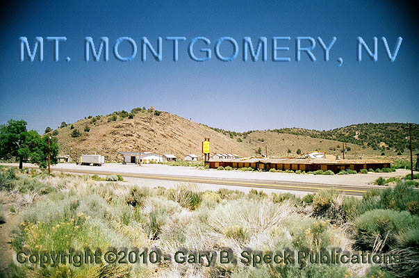
small, abandoned community sprawling across both sides of the highway.
Also known as BUENA VISTA, SUMMIT and SUNLAND, this
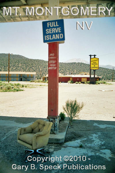
community was totally abandoned at the time I visited on July 5, 2008. Left to attract this old camera-totin’ ghost towner, were a
couple of motels across the highway from each other, a casino, a combination gas
station/repair garage, and a cluster of tourist
cabins. This little roadside
community looks like something out of the Twilight Zone TV
series. I don’t know much
about its history other than it was the site of a C&CRR
station and a post office once operated here. The post office was called BUENA VISTA, and was active from
December 14, 1905 through April 24, 1911, at which time the name was changed to
SUNLAND. It remained as Sunland
until it was discontinued a little over a year later on July 31, 1912. The post office was re-established as MT MONTGOMERY on September 22, 1916,
operating uninterrupted until September 30, 1945.
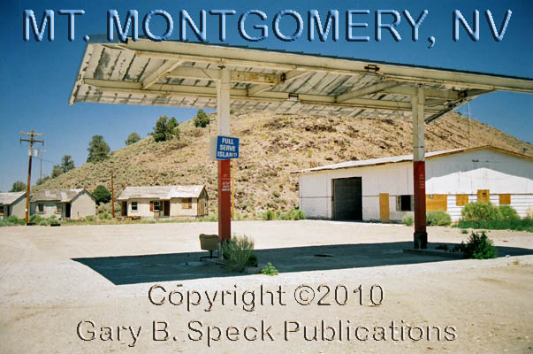
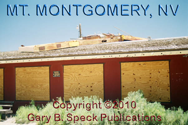
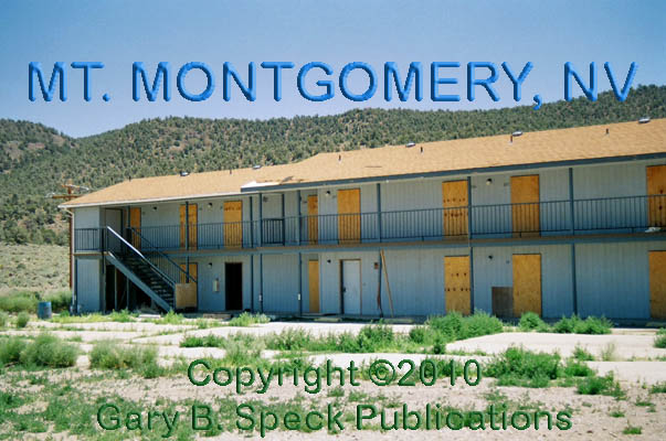
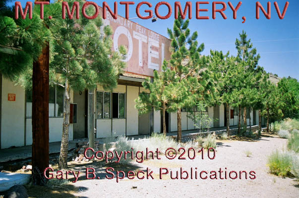
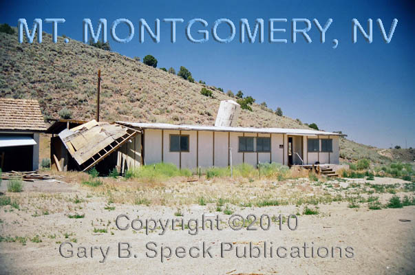
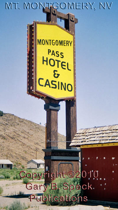
Remains include: the sprawling,
single-story, brick red Montgomery
Pass Casino with the
twisted remains of its roof-top
sign, and the adjacent Montgomery
Pass Motel, a two-story grey motel; the tall, two-legged canopy of
the gas station, the gaping open doors of the repair garage, and the crooked,
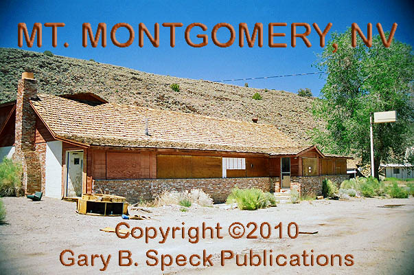
gap-toothed line of boarded-up tourist cabins/bungalows. Across the highway to the west are the Boundary
Peak Lodge and the adjacent dark brown, brick wainscoted restaurant,
both facing out onto the former grade of the C&CRR. Several modular/mobile homes
that probably housed employees round out the picture, all bringing back
memories of the glory days of roadtrippin’ when
cars couldn’t go so far between fill-ups,
and Nevada-bound tourists tried to beat the odds in off-the-wall casinos
in little, podunk, mapdot
towns.
On
the southeast side of the town site, behind the two-story motel were a number
of occupied structures, so please respect the rights of those property
owners. ALSO, please note that some
of the structures are posted “KEEP OUT”.
Abide by that request.
I
received the following E-mail from Daniel D. on July 18, 2010. “Someone burned the old casino down a few months ago. It is a total ruin with just a few walls
left. …The restaurant you
mention was in fact the first casino with some food available.”
This
is one of the reasons I try to photograph every building in each of the towns I
visit. You never know when a change
will occur. This is a sad
situation, that unfortunately will continue as long as there are people out
there that have no respect for other folk’s property. There are enough accidental and natural
“eliminations” without help from humans. Please be careful when you visit these
fragile relics of Americana, and treat them with respect. Thanks for the update Dan.
BASALT
About three miles northeast of MT MONTGOMERY is the junction of US 6/SH 360 and the barren site of BASALT.
BASALT was a C&CRR station and
prospector’s supply center. A post office operated here for a short time
- from March 20, through August 9, 1906.
The on-line GNIS aerial photos show a barren
site with numerous graded Aroads@ around
the site, south of the junction. It
also shows what appears to be - or have been - a landing strip. Nothing is visible from the highway, and
I saw nothing to indicate a town ever existed here.
Continuing east on US 6, we cross the ESMERALDA COUNTY LINE 6.2 miles east of BASALT. 18.5 miles later we reach COALDALE JUNCTION
– where US 95 rolls in from the north. The two highways then run co-joined for
the next 40+ miles until they split at the east end of TONOPAH.
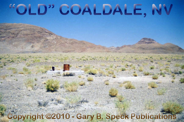
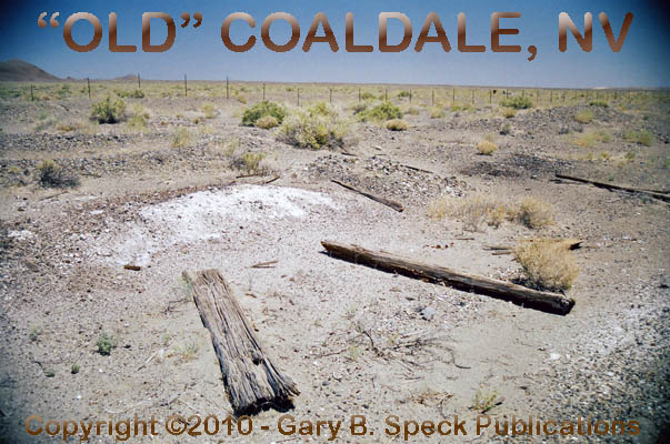
COALDALE
At Coaldale Junction, detour to the north
on US 95 for about three-quarters of a mile. This is the original, hard to locate
site of COALDALE. The now barren site is marked only by a
concrete well
casing, minor
debris, shards of broken purple glass and scattered cans that have
escaped the grinding blade of a bulldozer trying to erase or hide the memories
of OLD COALDALE.
The original town of COALDALE
was established in the 1880s by William Grötzinger,
who discovered coal in the southeastern end of the Silver Peak Range, about
2½ miles south-southeast of the site. A stage station also operated out
of the little coal camp. Not much
transpired until 1901, when TONOPAH
boomed. A forty-acre town site was
platted and the Tonopah & Goldfield Railroad (T&GRR) established
a station here. A post office
opened October 6, 1904, and remained open until July 28, 1908. The coal mines shut down around 1916. Around 1939 or 1940, US 95 replaced
State Highway (SH) 3, and a service station operated here until 1959. COALDALE never amounted to much, and
little remains to show it ever existed.
Across the highway, a small “V” shaped landing field once
existed, its site visible on the GNIS topographic map. One of the runways was 2900’ long
and the other about 2300’.
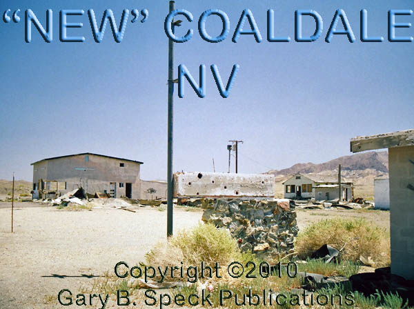
Sometime before or after COALDALE
died, the town relocated 1.2 miles to the south, to a spot about a quarter mile
south of Coaldale Junction.
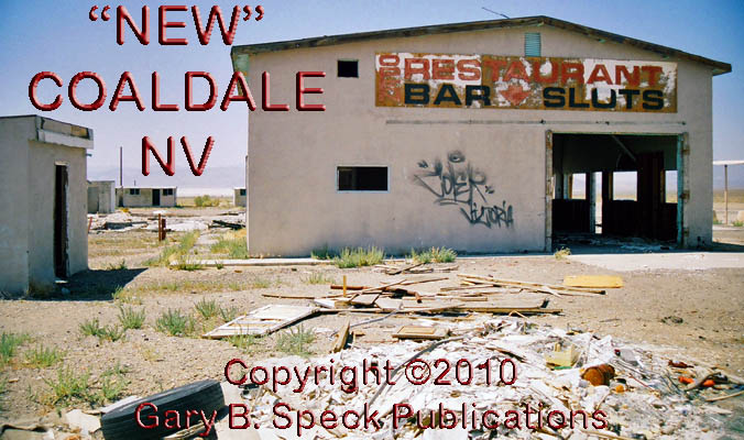
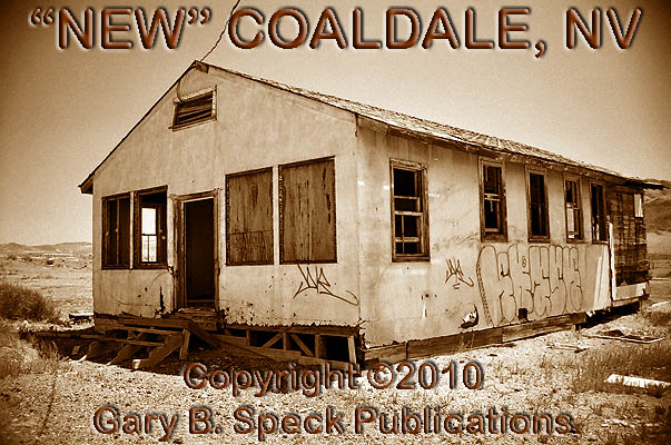
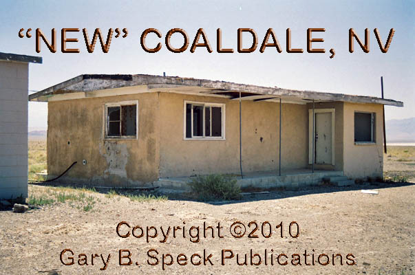
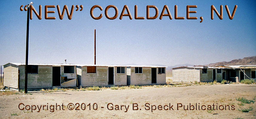
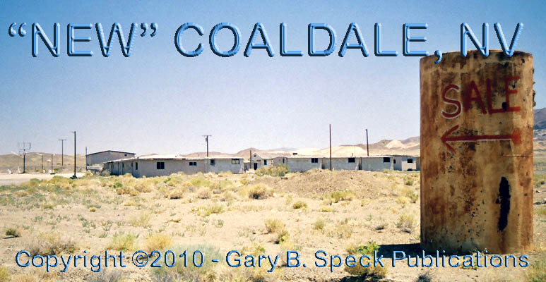
Along the south side of the highway, a handful
of pale white, empty mid
20th Century buildings that mark “NEW”
COALDALE. These buildings have
been heavily vandalized
and graffitied, and include a motel, garage, gas
station, and several unidentified buildings, one of which looks like it may
have been a school.
There are also several small houses
and cabins
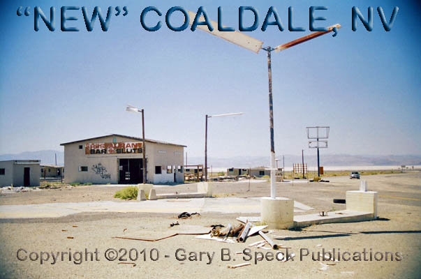
that may have been housing for employees of the community. Between the former motel
and gas
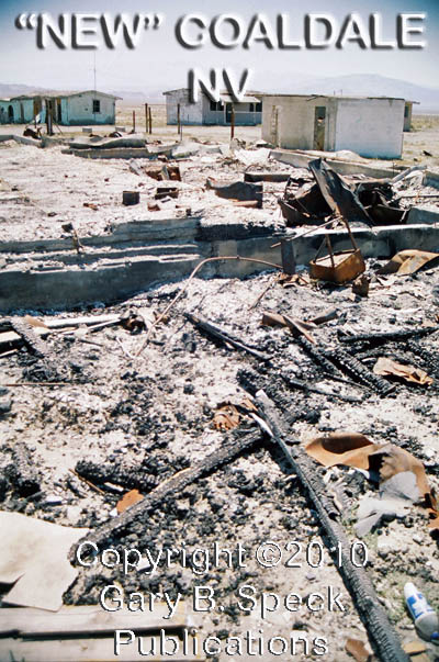
station, the burnt
rubble of a restaurant/casino has fallen into the basement. It was a
white, single-story, gable-roofed building that burned sometime between April
2002 and July 2006. A landing
strip is also located here, and shown on the GNIS map. It had a 3200’ dirt runway. The town faded and died probably in the
1990s.
BLAIR
JUNCTION
Continuing south from COALDALE
JUNCTION, US 6 reaches the barren site of BLAIR JUNCTION at mile 5.9.
This road junction is where SH
265 rolls up from the south. Eighteen miles to the south is the turn-off for
the ghost town of BLAIR, while three miles beyond is the semi-ghost of SILVER
PEAK. They were not on the
agenda for this trip, so I didn’t visit either of them. A little over a half mile south of the
junction and past a cell tower is the now barren site of the T&GRR/ Silver
Peak Railroad junction. The rail junction of BLAIR JUNCTION boomed during the 1907 era. An aerial photo shows dirt roads
(including the old railroad grade), but no buildings or foundations. The topo map
shows a dry well and dirt roads. A post office operated here November 18, 1920
– September 29, 1923. Nothing
was visible from either highway.
Continuing east towards Tonopah on US 6, the next site of interest
is McLEANS. This T&GRR station
was located 0.4 miles south of US 6-95 about a mile north of the big bend in
the highway. Its name was changed in 1925 to GILBERT JUNCTION. A
post office operated at the station April 9, 1925 - November 14, 1942. Nothing
remains here, or at …
BLACK
ROCK
…which is next in line. Black Rock is listed as a Apillar@ in the
online GNIS database, but the DeLorme Nevada
Atlas & Gazetteer shows it as a place name and an online
topographic map shows it as Black Rock/McLeans. Whether that was the rock, which is
highly visible alongside the highway, or an actual “road town” I
don’t know, but I suspect it was nothing more than the
“pillar” as this small outcropping is visible for miles and probably
served as a travel marker. No
remains of any town were visible, so this place will remain a mystery unless
one of you knows something about it.
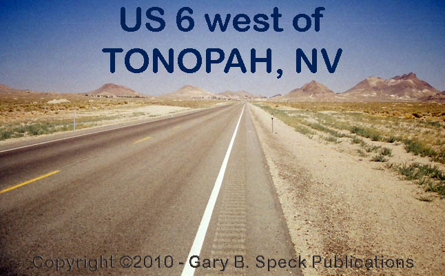
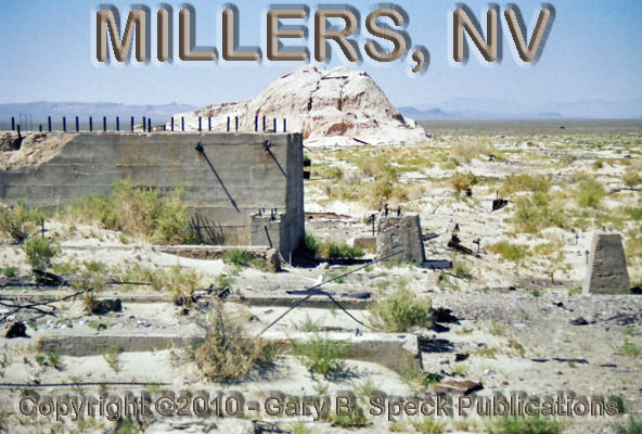
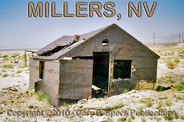
MILLERS
East of BLACK ROCK, US 6-95 makes
a bend towards the east, then southeast, taking aim on TONOPAH, visible in the saddle between the hills 15 miles in the
distance. Just as the road rolls
towards the southeast, a rest stop springs up like an oasis in the bleak, flat
desert, 20.3 miles east of BLACK ROCK. Across the street, opposite the west end
of the rest stop, a graded dirt road runs off to the south past a power
substation. About 1.5 miles south
of the highway is MILLERS, truly a stealth ghost town
that isn’t prominently featured in ghost town literature. It’s also not highly visible from
the highway, but is definitely worth a stop.
The sprawling remains of this wonderful old ghost remain hidden to
the vast majority of casual ghost town chasers who run through life with no
curiosity or a desire research out the stories and locations of these forgotten
places. The story of MILLERS begins in 1865 when Desert Wells STAGE Station was
established on the Silver Peak stage route to take advantage of a desert
watering hole. Then in 1901, and the boom at TONOPAH, it became an important water stop on the Tonopah
route. The T&GRR ran tracks
past the old stage station in 1904, establishing a railroad depot and repair
facilities here to take advantage of the water and nearness to the TONOPAH silver boom. Because of the
abundant water and the railroad facilities, several ore mills were built in
1906, and a year later the milling boom was at its peak. In 1910, the census
counted 274 people here along with a full compliment of businesses. MILLERS
began to fade in 1911 when the railroad moved its repair facilities elsewhere
and some of the TONOPAH mines established
milling facilities at or near the mines. In 1947 the railroad shut down and MILLERS closed up. A post office was in operation January
17, 1906 - September 12, 1919, and again February 16, 1921 – December 31,
1931.
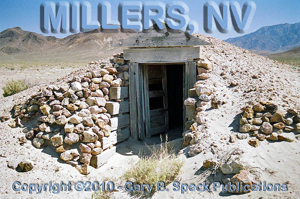
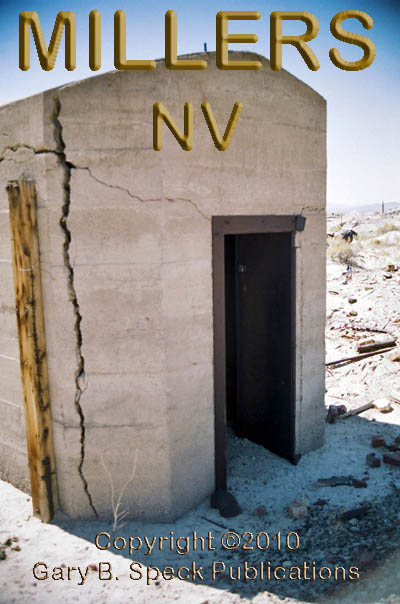
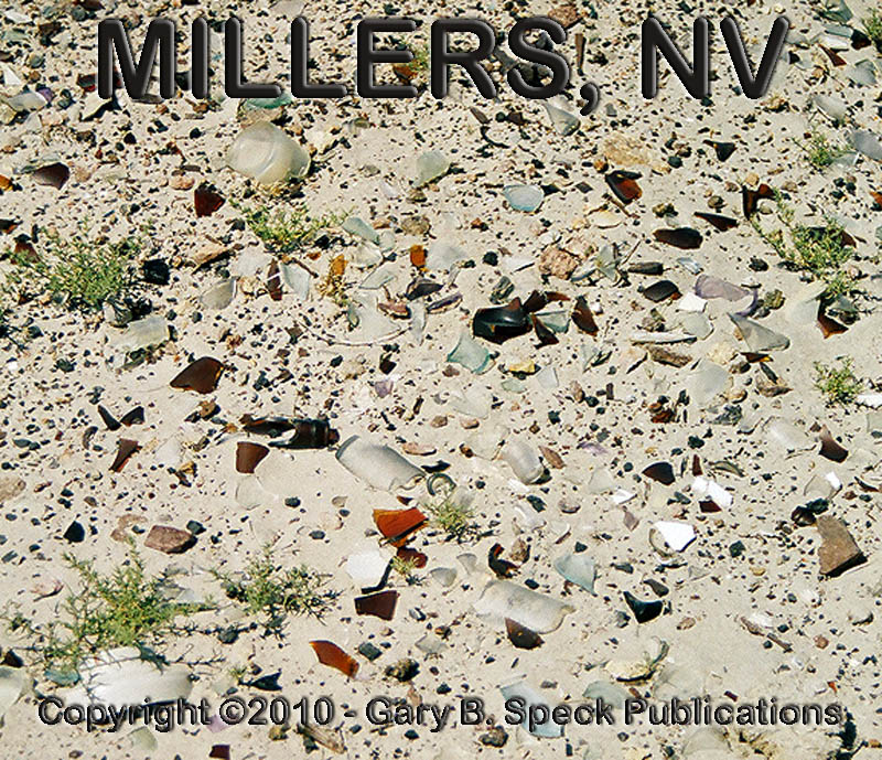
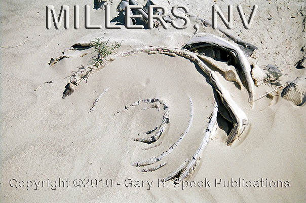
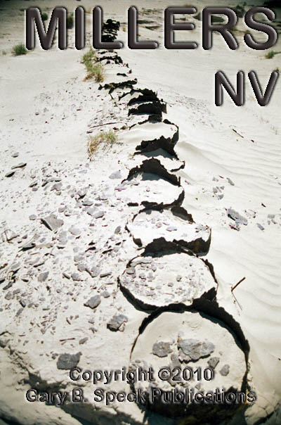
The site is spread out over some pretty extensive acreage, and is
filled with rubble, ruins and the massive concrete foundations of the
huge stamp mills. The railroad
grade is still visible, railroad
ties still in place. A dugout, a
concrete explosives
bunker and an old metal
building remain, along with foundations, walls and other
unidentifiable ruins. Broken
glass, rusted cans, coiled
hoses, rotten
barrels, wooden
pipes, twisted and broken power
poles, warped
& sand-blasted wood, relics
and other detritus lie scattered in the blow-sand all around the
site.
Returning to the highway, we continue east, heading towards TONOPAH. At the western outskirts of TONOPAH, the highway crosses the NYE
COUNTY LINE, passes the
cemetery on the southeast and enters this fabulous old silver mining town that
changed the face of Southern Nevada at the dawn of the 20th Century.
CONTINUED in PART
3…
PART
1: Bishop, CA to CA/NV State Line
PART 2: CA/NV State line to Tonopah, NV
PART
3: Tonopah to Warm Springs,
NV
PART
4: Warm Springs, NV to NV/UT State Line
PART
5: NV/UT State Line to the Tintic Mining District, UT
PART
6: The Tintic
Mining District to Price, UT
PART
7: Coal Mining Camps west of
Price, UT
GPS
and Standard Township/Range locations for the sites featured above
|
SITE NAME |
ELEV. |
LATITUDE |
LONGITUDE |
TOWNSHIP/RANGE |
|
Basalt (Mineral
Co.) |
6339’ |
38.0074300 / 38°
00’ 27” N |
-118.2731740 / 118°
16’ 23” W |
Sec
23, T2N, R33E, MDM* (* Mount Diablo Base Line & Meridian) |
|
Black Rock (Esmeralda
Co.) |
4787’ |
38.0749305 / 38°
04’ 30” N |
-117.6337080 / 117°
38’ 01” W |
NE3 Sec 31, T3N,
R39E, MDM |
|
Blair (Esmeralda
Co.) |
4616’ |
37.7929865 / 37°
47’ 35” N |
-117.6492601 / 117°
38’ 57” W |
SW3 Sec 3, SE3 Sec 4, T2S,
R39E, MDM |
|
Blair Junction (Road Jct |
4895’ |
38.0185419 / 38°
01’ 07” N |
-117.777045 / 117°
46’ 37” W |
NW3 Sec 20, T2N,
R38E, MDM |
|
Blair Junction (RR Jct) (Esmeralda Co.) |
4819’ |
38.0082642 / 38°
00’ 30” N |
-117.7737110 / 117°
46’ 25” W |
SE3 Sec 20, T2N,
R38E, MDM |
|
Coaldale Junction (Esmeralda Co.) |
4629’ |
38.0315972 / 38°
01’ 54” N |
-117.8870483 / 117°
53’ 13” W |
SW3 Sec 17, T2N,
R37E, MDM |
|
(NEW) Coaldale (Esmeralda Co.) |
4662’ |
38.0274306 / 38°
01’ 39” N |
-117.8831592 / 117°
52’ 59” W |
SE3 Sec 17, T2N,
R37E, MDM |
|
(OLD) Coaldale (Esmeralda Co.) |
4583’ |
38.042430 / 38°
02’ 33” N |
-117.8934376 / 117°
53’ 36” W |
SE3 Sec 8, T2N,
R37E, MDM |
|
Esmeralda/Mineral |
|
38.008844 |
-118.222084 |
|
|
Esmeralda/Nye |
|
38.077622 |
-117.249613 |
|
|
McLeans (Esmeralda Co.) |
4782’ |
38.0477086 /38°
02’ 52” N |
-117.6520413 / 117°
39’ 07” W |
N½
Sec 9, T2N, R38½E, MDM |
|
Millers
(Esmeralda Co.) |
4823’ |
38.1365977 / 38°
08’ 12” N |
-117.4575928 / 117°
27’ 27” W |
NW3 Sec 11, T3N,
R40E, MDM |
|
Millers Rest Stop (Esmeralda Co.) |
4823’ |
38.1404866 / 38°
08’ 26” N |
-117.4537038 / 117°
27’ 13” W |
SW3 Sec 2, T3N,
R40E, MDM |
|
|
6450’ |
37.8285428 /
37° 49' 43"
N |
-118.4309530 /
118° 25' 51"
W |
SE3 Sec 27, T1S,
R32E, MDM |
|
|
6201’ |
37.7638206 /
37° 45' 50"
N |
-118.4009508 /
118° 24' 03"
W |
NW3 Sec 24, T2S,
R32E, MDM |
|
Queen (Mineral
Co.) |
7149’ |
37.9735415 / 37°
58’ 25” N |
-118.3267863 / 118°
19’ 36” W |
N2 Sec 5, T1N,
R33E, MDM |
|
|
7129’ |
37.9796525 / 37°
58’ 47” N |
-118.3215086 / 118°
19’ 17” W |
SE3 Sec 32, T2N,
R33E, MDM |
|
State Line (CA/NV) |
6174’ |
37.9315979 / 37°
55’ 54” N |
-118.4429002 / 118°
24’ 34” W |
E2 Sec 21, T1N,
R32E, MDM |
|
Tonopah
(Nye Co.) |
4823’ |
38.0671553 / 38°
04’ 02” N |
-117.2300825 / 117°
13’ 48” W |
S½
Sec 35, T3N, R42E, MDM, N½
Sec 2, T2N, R42E, MDM |
|
Historians estimate that
there may be as many as 50,000 ghost towns scattered across the The Ghost Town
Guru's Guide
to the Ghost Towns of “STATE”™ These original guides
are designed for anybody interested in ghost towns. Whether you are a casual
tourist looking for a new and different place to visit, or a hard-core ghost
town researcher, these guides will be just right for you. With over 30 years
of research behind them, they will be a welcome addition to any ghost towner's library.
Thank you, and we'll see you out on the Ghost
Town Trail! For more information on
the ghost towns along this portion of E-mailers,
PLEASE NOTE: Due
to the tremendous amount of viruses, worms and “spam,” out there,
I no longer open or respond to e-mails with unsolicited attachments, OR
messages on the subject lines with “Hey”, “Hi”,
“Need help”, “Help Please”, “???”,
or blank subject lines, etc. If
you do send E-mail asking for information, or sharing information, PLEASE indicate the
appropriate location AND state name, or other topic on the
“subject” line. THANK
YOU! :o) |
IMPORTANT These listings and
historical vignettes of ghost towns, near-ghost towns and other historical
sites along this portion of US HIGHWAY 6 above are for informational
purposes only, and should NOT be construed to grant permission to trespass,
metal detect, relic or treasure hunt at any of the listed sites. If the reader of this
guide is a metal detector user and plans to use this guide to locate sites
for metal detecting or relic hunting, it is the READER'S responsibility to
obtain written permission from the legal property owners. Please be advised,
that any state or nationally owned sites will probably be off-limits to metal
detector use. Also be aware of any federal, state or local laws restricting
the same. When
you are exploring the ghost towns along Ghost Towner's
Code of Ethics. |
Also
visit: Ghost Town
Home
Page | Site Map | Ghost Town Listings
| On
the Road Again | Photo Gallery
| Treasure
Legends
CURRENT Ghost Town of the
Month | PAST Ghost Towns
of the Month
Ghost Towner's
Code of Ethics | Publications | Genealogy
| License Plate
Collecting
A few LINKS to outside webpages:
Ghost
Towns | Treasure
Hunting | License
Plate Collecting | Genealogy
***
THIS PAGE
FIRST POSTED: February
6, 2010
***
This entire website, and all individual web pages
is
copyright
© 1998-2017
by Gary B Speck Publications
ALL rights reserved