ON THE ROAD AGAIN
With Ghost Town
A Tour Guide
to the Ghost Towns Along
From Bishop, California
to
Price, Utah
PART 5
The NV/Ut State Line to the Tintic Mining District, Ut
CONTINUED from PART
4…
From
BORDER to the next stop is about 100
miles of desert, with nary a spot to stop and take pictures of abandoned
buildings. Deep in the heart of the
Great Basin, Millard County, Utah is 6818 square miles of wide-open, mostly
desert country in the west-central part of the state. Millard is the third largest county in
area and the 18th most populous - with only a tad over 12,000
people. The route from BORDER to DELTA is pretty much a non-event, and a portion of the route is
actually not the original tracing of US 6/50. However the original part that has been
bypassed is so lost it doesn’t show on maps, nor is it visible on the
GNIS aerial photos.
From
DELTA, we’ll take a little
loop trip to the north through some of the badly faded agricultural
communities, a WWII Japanese
Relocation Center, then loop south of US 6/50 and visit an old Mormon
fort and several other faded farm towns all plopped in the heart of a 43,000
acre agricultural region.
SUTHERLAND
Our
first stop is SUTHERLAND, located
four miles northwest of Delta. This
faded agricultural community is one of the oldest settlements in this area,
dating to the 1890s. It currently
has about 120 people and has a large Mormon church, a cluster of homes, but no
commercial buildings. During the early 1900s, the Union Pacific Railroad
undertook a campaign to tout the agricultural potential of this entire
area. Obviously their ultimate
motive was to draw farmers to the isolated area, and those farms would ship
goods and require goods and services in return: a situation the railroad
company would be happy to expand on.
Since most of the land in the area was available for settlement under
the Carey Land Act, a land boom quickly developed. (SEE the online Wikipedia entry for
details on this act.) Unfortunately
water was not easy to obtain and most of the farms died out. Acreage was consolidated and most of the
new, farming boomtowns quickly faded.
Some survived, at least in name.
Sutherland is one of those.
Nothing of historical interest remains.
WOODROW
Next
up at the junction of roads N3000W/W5500N is WOODROW, another Carey Act boomtown located three miles north of
Sutherland. This tiny cluster of
residences was originally called Rock District. It was established in 1909, changing its
name to Woodrow in 1913 to honor Woodrow Wilson, who was elected president in
1912. During the late teens WOODROW was a lively little town
consisting of a community hall, general store, post office and school. By the 1970s it faded and only had
scattered houses and the abandoned hall.
In 2008, all I saw were a few scattered farms around the intersection.
SUGARVILLE
Three
miles northwest of WOODROW is the
nearly extinct community of SUGARVILLE. This agricultural map dot has about 30
people and othing of any historical interest
remaining. It is located at the
intersection of W7500N / N4000W.
These road names look funny in written format, but when viewed on a grid
map make a lot of sense.
LUCERNE
Next
up was the barren site of LUCERNE.
It is located south of the junction of SH 174 and N4000W. No sign of this former town
remains. A dirt
“Y” is visible in the GNIS aerial photo about a ½ mile west
of the road and about ¾ mile south of the power lines. This MAY be the
remains of the railroad wye built by the Union
Pacific Railroad. Lucerne was born
in 1909, and was originally called Alfalfa. In 1925 the Union Pacific built a spur
line here, and Lucerne boomed as a shipping center. By 1931, it went bust.
SUNFLOWER
SUNFLOWER is the next town,
but with the lack of physical remains previously found, my hopes were rapidly
dimming. Two farms at the
intersection of N7500W/W7500N mark this old agricultural community. Sunflower was established in 1912, and
died by the late 1920s. It once had
a school, but it was struck by lightning in the early 20th Century,
burning to the ground. Nothing
remains.
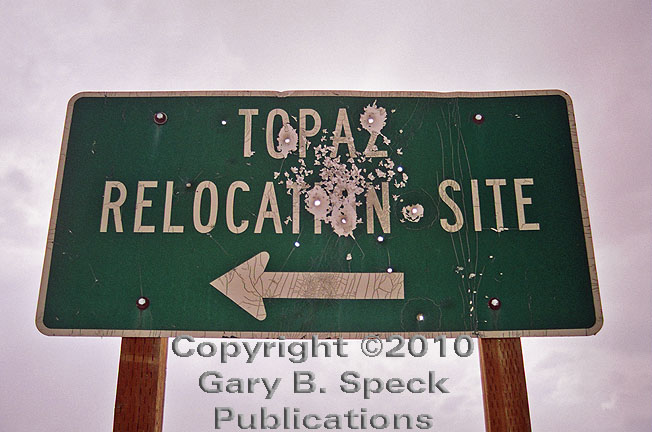
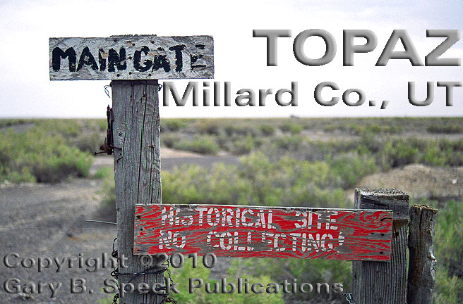
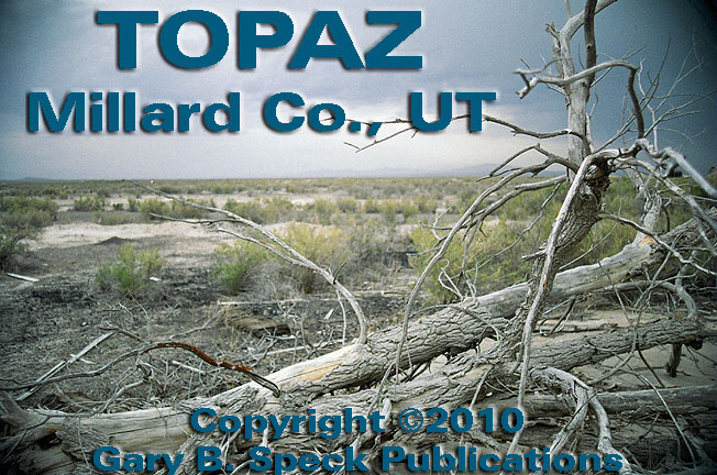
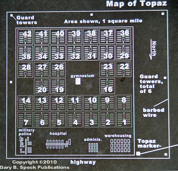
The
next site is TOPAZ, the site of a
WWII Japanese
relocation center located 16 miles northwest of Delta. Prior to leaving on this
trip, I noted with delight that online aerial photos showed outlines of
streets, barracks blocks and other buildings. Tangible remains appeared present, and I
looked forward to that discovery.
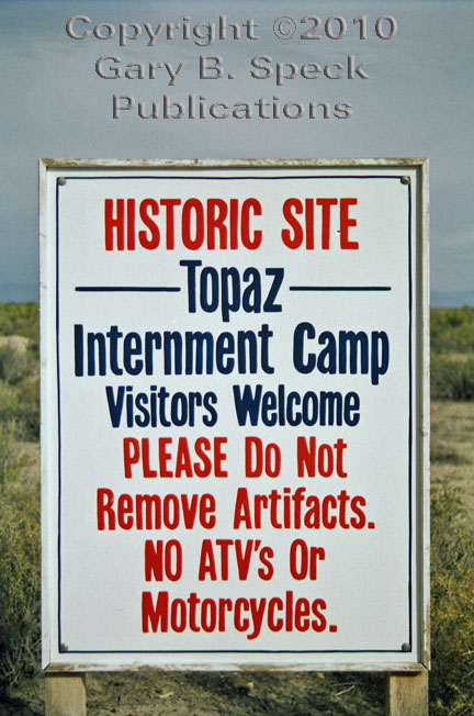
Upon arrival I was not disappointed. This historic
site (sorry
– no metal detectors allowed inside the site) is unrestored. Located in the unrelenting flat Utah
desert, the site doesn’t have the scenic appeal of eastern
California’s MANZANAR
RELOCATION CENTER. BUT, what it lacks
in physical appeal it makes up for in solitude. I was the only person there,
and a towering thunderstorm off to the north sent grumbles of thunder on the
brisk sagebrush and rain-scented breeze.
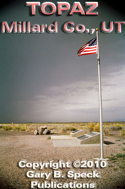
The ghosts of the not too distant past rustled restlessly in the desert
zephyr while Old
Glory stood
at attention, highlighted by a few stray rays of sunshine penetrating the
clouds. Reading the historical
plaques at the northwest corner of the site, I soaked up the historic ambiance
of this place, and learned a little of the story
of Topaz. One of the real treats was an aerial
photo that was probably taken
from one of the guard towers. Upon
entry to the site, the understated welcome signs
usher you past the enclosing fence where someone got a little creative,
spelling out the camp’s name with barbed wire, interwoven in the
chain link fencing.
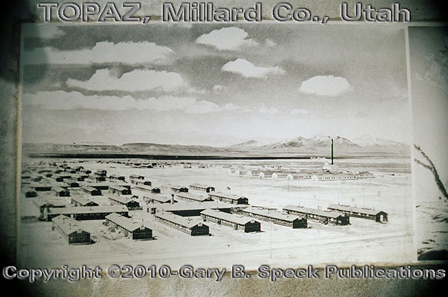
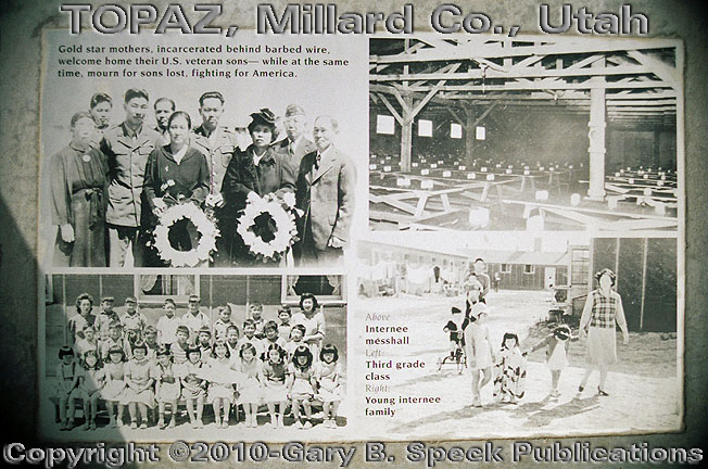
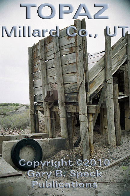
Topaz
operated from September 11, 1942 - October 31, 1945. At its peak, the relocation center was
the fifth largest city in Utah and contained 623 buildings and 8130 internees (another source
claims 8316) mostly from the San Francisco Bay area of Northern California. The
remaining square-mile residential and administrative
area was just a small part of the overall
complex, of 19,800 acres. The
outlying acreage was used for agricultural purposes, nearly surrounding the
little farm town ABRAHAM. Scattered
across this outlying area, a few ruins and standing buildings remain, but under
private ownership. In the
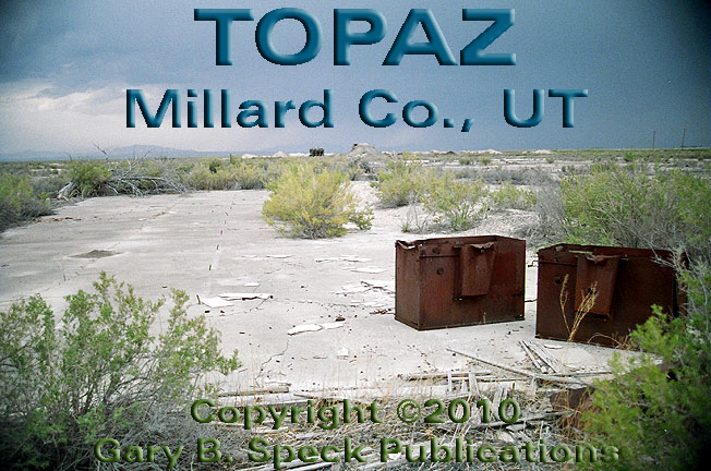
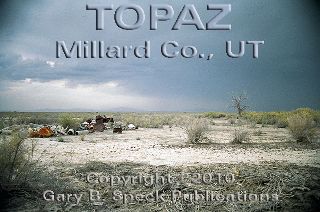
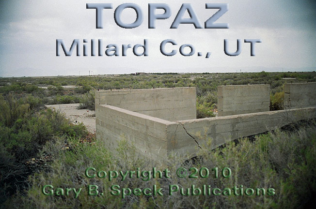
mile-square, marked historical area, no standing buildings remain from the
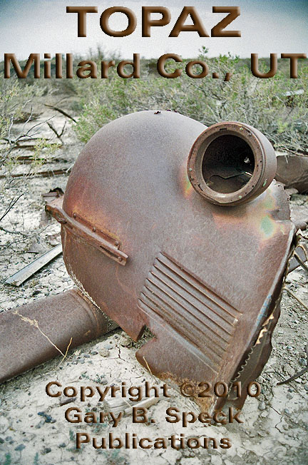
1940s. However, a lot of slabs, debris and dead
trees
do remain. One structure, a gravel
chute,
actually postdates the relocation center/internment camp. Most of the onsite roads are drivable
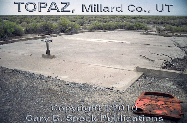
but the desert scrub that has taken over the site encroaches onto most of the
roads. A few of the building sites
are marked, including the administration
area, boiler
house (adjacent to the unmarked
ruins of the hospital), fire
station and laundry
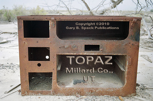
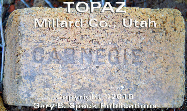
building, among others. Cook
stoves still sit on the slabs of the long gone mess halls, while bricks
and car
parts still lie scattered about.
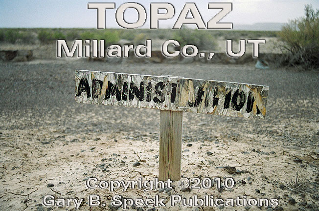
There
are no brochures available onsite to lend a hand in identification of the
unmarked ones, but at the front entry several monuments have inset plaques, one
of which contains a plot
plan of
the site. In the southeastern
corner are a few privately-owned mobile and stick-built homes postdating the
relocation center, and predating establishment of the historical site. Please do not trespass or disturb those
residents. The rest of the site is
open, unspoiled, unrestored and unassuming.
This is one of the locations
featured in my newest book, GHOST
TOWNS: Yesterday & TodayTM.
Just
outside TOPAZ, I headed south on
N7500W, passing through the rural farming community of ABRAHAM, through HINCKLEY,
crossed US 6/50 and aimed my car towards DESERET.
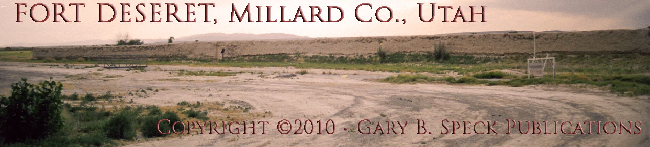
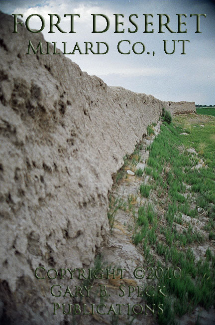
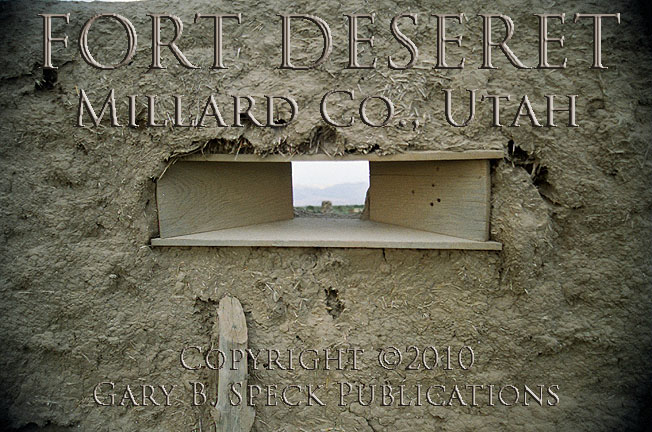
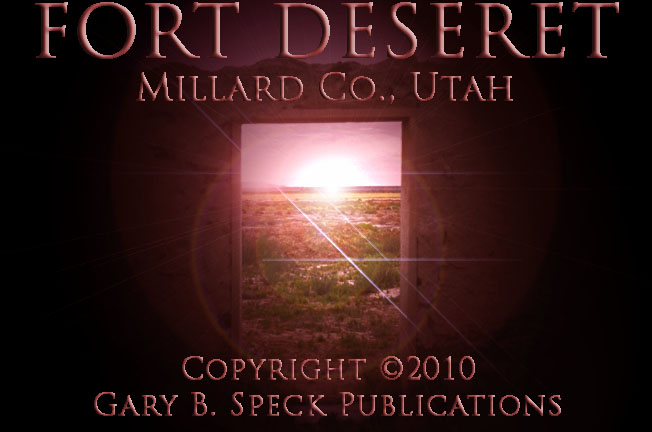
DESERET/ FORT DESERET
This
neat little agricultural town sits on the south side of the Sevier River. It is the oldest town in this region,
dating to 1860. Some 300 people and
a picturesque old
false front give it character.
The true gem lies west of SH 257, just 1.5 miles south of Deseret. The low, adobe-walled remains of
historic Fort
Deseret are the remains of a privately built and owned fort. Here in 1865 a 550 foot square, ten foot
high mud-walled
refuge was
built to give the settlers from Deseret a place of refuge in case of trouble
from the local Pahvant Indians during the Black Hawk
war. In 1866 it was used to protect the settlers’ livestock, but the
issue with the Pahvant Indians was resolved quickly
and peacefully. Gun
ports
gave the settlers a protected view of any approaching trouble, and solid wooden
doors would lock it out. Today, the
door serves as a portal
to allow travelers step back in time and imagine how hard life was on the Utah
frontier.
OASIS
Leaving
FORT DESERET, I headed back north to
DESERET then turned east on W4500S,
then north, to OASIS. This worn-out
little
farming town lies between Delta and DESERET and the railroad and didn’t have much going for it
until I spotted an old
brick store. Despite the
barking of a couple of fenced-in dogs and curious stares from a couple of
locals wondering what a car from California is doing in their town, the
occupant taking pictures of an old beat-up store building. If any read this web site, they’ll
know who that was!
OASIS was an outgrowth
of DESERET, and was established in
March 1891. Unfortunately the
agricultural opportunities in the area are limited due to water issues, and the
little town faded. Today around 100
folks hunker down in this moldering old town along the railroad. There are also some large
agricultural-related buildings along the tracks.
Leaving
OASIS, I spent the night in DELTA, a prosperous town that contains
over a third of the county’s population. The next morning I grabbed a couple
breakfast burritos from Mickey D’s and hit the road. At the east end of DELTA, the highway splits.
US 50 peels off and heads southwest and aims
for the junction of I-15/I-70, where it runs off to the east towards Denver,
CO. US 6 At Green River, it streaks
northeast, arrowing across the flat Sevier Desert
into the heart of Utah. It loops up
and meets I-15 near Springville, then heads back southeast towards Green River
where it remarries US 50.
CLINE
Little attracts attention in this first leg
of the journey out of DELTA on US
6. Prior to leaving on this trip I
spent some quality time with a 1938 road atlas and some gas company maps from
the 1950s and 1960s, finding a number of locations NOT marked on present
maps. One of these is CLINE,
which was shown on a 1957 Union 76 highway map four miles southwest of Lynndyl
and 16 miles northeast of the junction of US 6/50 in DELTA. It was not
listed on the GNIS website as a place name, nor is it shown on the online
topographic maps, so the only indication I could find that it ever existed was
on that single map. Nothing was
visible at the site. Originally I
thought this might be a Copyright
town,
but it looks like it was a railroad station established on the San Pedro, Los
Angeles and Salt Lake Railroad (the line is now operated by the Union Pacific
Railroad). CLINE is listed in the 1907 Official Railway Guide, and is shown on
a 1914 map. I have not seen those
original documents so can’t verify that. However, it looks like it was a railroad
station, although nothing is visible today.
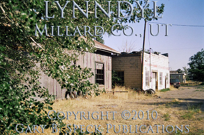
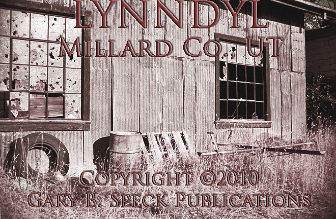
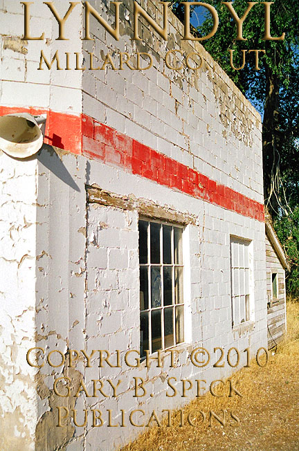
LYNNDYL
Four
miles to the northeast is the real town of LYNNDYL.
In 2000, this sleepy agricultural community had 134 people, less
than half the folks it tallied in 1940, when it claimed 372 people. This Semi-ghost
town, does have some ghostly airs about it, including a handful of
abandoned buildings which include two
garages and boarded
up houses. LYNNDYL is located at the junction of US
6/SH 132, 20 miles northeast of Delta and 32 miles southwest of Eureka.
In the 1940 edition of the American Guide Series, Guide to Utah (WPA), Lynndyl
is described as a “division point
on the Union Pacific Railroad (and) a trading center for the Pahvant Valley farmers.” The pair of garages are
my favorites. The southern one is
constructed of corrugated
tin, while the northernmost one
is built of masonry. A faded red
stripe bisects white walls covered with peeling
paint. Junk
in the windows and old tires in the weeds add character.
CHAMPLIN
Like CLINE,
CHAMPLIN is shown on the Union 76 map at a point eight miles northeast of Lynndyl on a dogleg in the highway. It was not shown on
other maps in my collection. GNIS locates it along
the railroad about a half mile north of that highway bend. Nothing was visible
along the highway, along the railroad from the highway, nor is anything visible
on the GNIS aerial photo
except a long siding or section of double track. It is currently listed in railroad
documents as a siding on the Union Pacific (UP) Railroad. CHAMPLIN’s
main claim to fame appears to be that on July 27, 2006, a collision and
subsequent partial derailment occurred between two UP Trains at the
siding. One train was sitting on
the siding to allow another train to pass by on the single track main
line. However, the tail end of the
train still encroached onto the main line.
The second train struck those cars and derailed three of them. The two lead locomotives on the main
line train were also derailed, but no injuries were suffered by crew members.
JERICHO, JERICHO
JUNCTION
Next up is JERICHO JUNCTION and JERICHO. The junction is pretty straight forward,
but the other site is an enigma, and a confusing one at that! In 1940, Utah was the fifth
largest wool producing state in the nation and according to the WPA Guide was
one of the “leading wool shipping points in the West.” It was located 17.7 miles north of Lynndyl
and 18.7 miles south of
First, let’s place JERICHO JUNCTION. It is located at the junction of
The physical location of JERICHO itself is a bit confusing.
Unfortunately I did not research this site thoroughly before leaving, so looked
in the wrong location for it, seeing nothing. GNIS shows JERICHO along the railroad about 2.5
miles north of Jericho Junction.
The aerial photo shows four large metal-roofed buildings (shearing
sheds?), several foundation outlines/ walls and corrals. I believe this is the
place. It is also listed on UP
documents as a station and siding.
Other maps show it in different locations, such as: at the junction;
along the west side of the highway about a mile or two north of the junction,
across from a highway rest stop; on the highway about four miles north of the
junction (20 miles north of Lynndyl).
It appears that this site has either
wandered about, or the cartographers don’t know where it belongs either.
If you look for it, I’d recommend using the aerial photos from GNIS as the main guide
for locating this site.
Nearby is the Little Sahara Sand Dunes, a popular off-road vehicle
recreational area.
McINTYRE
Continuing north, the highway makes a big,
sweeping “S” curve, before straightening out and taking aim on the Tintic Hills.
Just north of that last curve is another railroad
siding called McINTYRE. It is/was
located north of where McIntyre Road crosses the railroad 1.5 miles west of US
6/50 and was named after the nearby McIntyre Ranch. Nothing was visible.
From McIntyre, we begin to climb towards
the Tintic
Mining District and the next leg of our journey.
CONTINUED in PART
6
PART
1: Bishop, CA to CA/NV State Line
PART
2: CA/NV State line to
PART
3: Tonopah to Warm Springs,
NV
PART
4: Warm Springs, NV to NV/UT State Line
PART 5: NV/UT State Line to the Tintic
Mining District, UT
PART
6: The Tintic
Mining District to Price, UT
PART
7: Coal Mining Camps west of
Price, UT
GPS
and Standard Township/Range locations for the sites featured above
|
SITE NAME |
ELEV. |
LATITUDE |
LONGITUDE |
TOWNSHIP/RANGE |
|
Abraham (Millard
Co.) |
4593’ |
39.3966197 /
39° 23' 48"
N |
-112.7180077 /
112° 43' 05"
W |
Ctr Sec 26, T16S,
R8W, SLM* (*Salt |
|
Champlin (Juab Co.) |
4964’ |
39.6510610 /
39° 39' 04" N |
-112.3038352 /
112° 18' 14"
W |
SW3 Sec 33, T14S,
R4W, SLM |
|
Cline (Millard
Co.) |
39.472693 |
-112.421626 |
SW3 Sec 33, T15S,
R5W, SLM |
|
|
Delta (Millard
Co.) |
4639’ |
39.3521777 /
39° 21' 08"
N |
-112.5771700 /
112° 34' 38"
W |
E½
Sec 12, T17S, R7W, W½ Sec 7, T17S, R6W, SLM |
|
Deseret (Millard
Co.) |
4590’ |
39.2869010 /
39° 17' 13"
N |
-112.6527270 /
112° 39' 10"
W |
SE3 Sec 32, SW3 Sec 33, T17S,
R7W, NE3 Sec 5, NW3 Sec 4, T18S,
R7W, SLM |
|
Deseret –
old false front |
|
39.286690 |
-112.652111 |
NW
corner Sec 4, T18S, R7W, SLM |
|
Fort Deseret (Millard
Co.) |
4583’ |
39.2646794 /
39° 15' 53"
N |
-112.6546713 /
112° 39' 17"
W |
E
Ctr Sec 8, T18S, R7W, SLM |
|
Hinckley (Millard
Co.) |
4603’ |
39.3249554 /
39° 19' 30"
N |
-112.6710613 /
112° 40' 16"
W |
E½
Sec 19, W½ Sec 20, T17S, R6W, SLM |
|
Jericho (Juab
Co.) |
5318’ |
39.7502266 /
39° 45' 01"
N |
-112. 2055017
/ 112° 12' 27"
W |
Ctr Sec 29, T12S,
R3W, SLM |
|
Jericho Junction (Juab Co.) |
5216’ |
39.7135606 /
39° 42' 49"
N |
-112.2021675 /
112° 12' 08"
W |
SE3 Sec 5, NE3 Sec 8, T13S,
R3W, SLM |
|
Lucerne –
Possible railroad “Y” |
|
39.490645 APPROX |
-112.658637 APPROX |
|
|
Lynndyl (Millard Co.) Junction of Main/Center streets |
4783’ |
39.5191190 /
39° 31' 09"
N |
-112.3357785 /
112° 22' 33"
W |
Sec
14, T15S, R5W, SLM |
|
McIntyre (Juab
Co.) |
5577’ |
39.8346714 /
39° 50' 05"
N |
-112.1691125 /
112° 10' 09"
W |
SW3 Sec 27, T11S,
R3W, SLM |
|
Oasis (Millard
Co.) |
4590’ |
39.2938455 /
39° 17’
38” N |
-112.6282819 /
112° 37’
42” W |
W
Ctr Sec 34, T17S, R7W, SLM |
|
Oasis –
old brick store |
|
39.294083 |
-112.627448 |
|
|
Sugarville (Millard Co.) |
4583’ |
39.4652297 /
39° 27’
55” N |
-112.6493954 /
112° 38’
58” W |
NW
corner, Sec 4, T16S, R7W, SLM |
|
Sunflower (Millard
Co.) |
4577’ |
39.4655069 /
39° 27' 56"
N |
-112.7091193 /
112° 42' 33"
W |
SE3 Sec 35, T15S,
R8W, SLM |
|
Sutherland (Millard
Co.) |
4626’ |
39.3888429 /
39° 23' 20"
N |
-112.6335609 /
112° 38' 01"
W |
SW3 Sec 27, SE3 Sec 28, T16S,
R7W, SLM |
|
Topaz
Relocation Center (Millard
Co.) |
4573’ |
39.4143965 /
39° 24' 52"
N |
-112.7727318 /
112° 46' 22"
W |
Sec
20, T16S, R8W, SLM |
|
Woodrow (Millard
Co.) |
4606’ |
39.4327307 /
39° 25' 58"
N |
-112.6332835 /
112° 38' 00"
W |
SE
corner Sec 9, SW corner Sec 10,
NE corner Sec 16, NW corner Sec 15 T16S, R7W, SLM |
|
Historians estimate that
there may be as many as 50,000 ghost towns scattered across the The Ghost Town
Guru's Guide
to the Ghost Towns of “STATE”™ These original guides
are designed for anybody interested in ghost towns. Whether you are a casual
tourist looking for a new and different place to visit, or a hard-core ghost
town researcher, these guides will be just right for you. With over 30 years
of research behind them, they will be a welcome addition to any ghost towner's library.
Thank you, and we'll see you out on the
Ghost Town Trail! For more information on
the ghost towns along this portion of E-mailers,
PLEASE NOTE: Due
to the tremendous amount of viruses, worms and “spam,” out there,
I no longer open or respond to e-mails with unsolicited attachments, OR
messages on the subject lines with “Hey”, “Hi”,
“Need help”, “Help Please”, “???”,
or blank subject lines, etc. If
you do send E-mail asking for information, or sharing information, PLEASE indicate the
appropriate location AND state name, or other topic on the
“subject” line. THANK
YOU! :o) |
IMPORTANT These listings and
historical vignettes of ghost towns, near-ghost towns and other historical sites
along this portion of US HIGHWAY 6 above are for informational
purposes only, and should NOT be construed to grant permission to trespass,
metal detect, relic or treasure hunt at any of the listed sites. If the reader of this
guide is a metal detector user and plans to use this guide to locate sites
for metal detecting or relic hunting, it is the READER'S responsibility to
obtain written permission from the legal property owners. Please be advised,
that any state or nationally owned sites will probably be off-limits to metal
detector use. Also be aware of any federal, state or local laws restricting
the same. When
you are exploring the ghost towns along Ghost Towner's
Code of Ethics. |
Also visit: Ghost Town
Home
Page | Site Map | Ghost Town Listings
| On
the Road Again | Photo Gallery
| Treasure
Legends
CURRENT Ghost Town of the
Month | PAST Ghost Towns
of the Month
Ghost Towner's
Code of Ethics | Publications | Genealogy
| License Plate
Collecting
A few LINKS to outside webpages:
Ghost
Towns | Treasure
Hunting | License
Plate Collecting | Genealogy
***
THIS PAGE
FIRST POSTED: April 15, 2010
***
This entire website, and all individual web pages
is
copyright
© 1998-2017
by Gary B Speck Publications
ALL rights reserved