ON THE ROAD AGAIN
With Ghost Town
A Tour Guide
to the Ghost Towns Along
From Bishop, California
to
Price, Utah
PART 1
Bishop, CA to the CA/NV State Line
ROAD TRIP!!! AHHH!!! The
open road. Adventure calls
all of us to get out, crank up the tunes, let the top down - IF you have a
convertible - or open the windows and let Mother Nature flood the car with the
sights, sounds and smells of the open road. Roadtrippin’
is good for the soul. The need to
explore, see what’s around the next bend, what’s over the next hill
feeds our desire to get out and experience what hidden gems this wonderful
country has tucked along its blue
highways. In fact, this Pennsylvania
license plate spotted on another “Toad Rip” in the Keystone
State says it all!
It was July 5th,
2008. I was ready. I’d finished my breakfast burrito
from that “Famous Fast Food” joint in Bishop, California, the gas tank on the Ghost Town Express was filled to the
brim, and my little car was crammed full of all the necessities for a
successful road trip. Maps were
marked up and keyed to notebook pages overfilled with historical minutiae,
there was a fresh tape lodged in the mini-cassette recorder, the laptop and
camera batteries were fully charged and the GPS was plugged in and set to
“Map Mode”. Darlene Zschech, the Beach Boys, Robin Mark, the Moody Blues, Kitaro and Coyote Old Man were loaded into the CD
player. I rolled down the windows
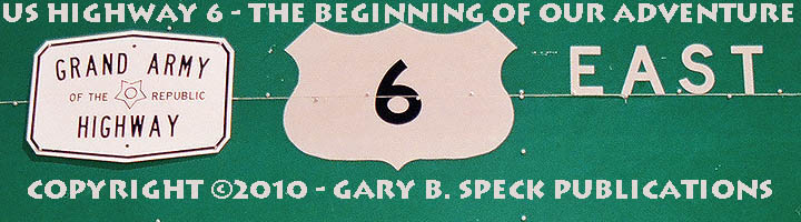
and headed out to see what US Highway 6 – the “Grand
Army of the Republic” Highway – had to offer.
This fascinating
road to adventure originally began its cross-country jaunt at the traffic
circle in the coastal city of Long Beach, 20-some miles south of Los
Angeles. But, it’s been
pruned somewhat. The 312-mile
stretch from Long Beach to Palmdale, to Mojave, to Lone Pine, to Bishop was
renamed, relocated and covered up by a plethora of other highways. So, in 1964, the western anchor of
America’s longest cross-country highway that used to run literally from
“Sea to Shining Sea” had nearly ten percent of its length lopped
off. The western anchor was
uprooted and relocated to Bishop, booting this road from the longest to the
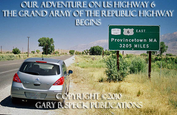
second longest, behind US 20: from 3517 miles to 3205. It still runs through 14 states and the
eastern end still wraps firmly around the scorpion-tailed tip of Cape Cod,
ending its run at Provincetown, Massachusetts.
Our journey begins
on a warm July morning at the quiet intersection just east of the Shell gas
station at the north end of Bishop where US 395 makes its 90 degree bend. This semi-hidden junction marks the real
beginning of our adventure,
despite what the sign says on the opposite
side of
the street. Heading north on 6, the road shoots straight out of Bishop for
about a mile, then hangs an east turn, running straight for another 2½
miles. Then it jogs back to the
north, heading towards Nevada. At
that jog is the small town of LAWS,
our first stop.
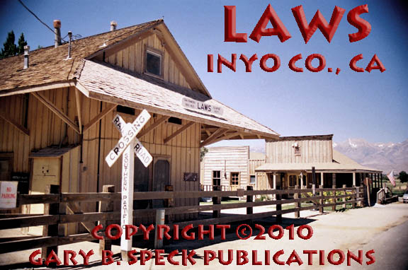
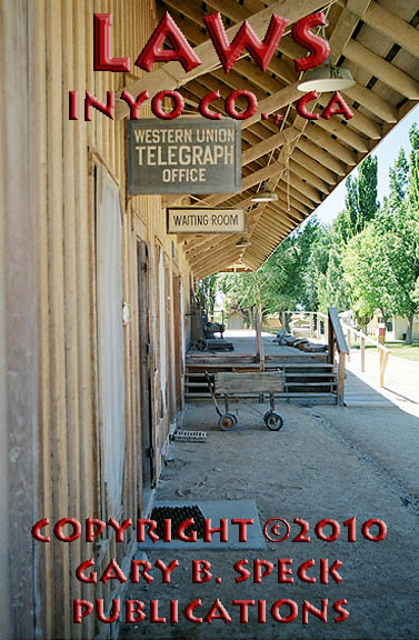
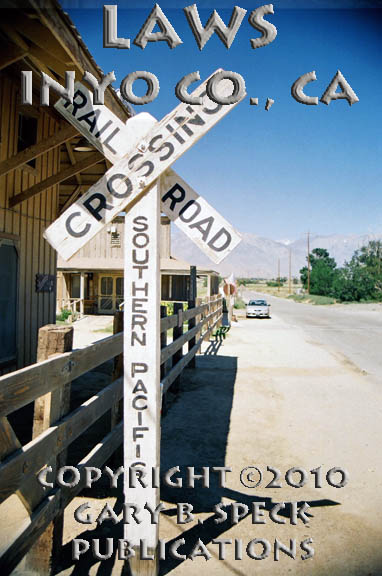
LAWS
LAWS reeks of history. It sits on the east side of the
previously-mentioned big ninety-degree bend at mile
post (MP) 4 just east of the
Owens River, about four miles northeast of Bishop and just south of the
Inyo/Mono County line. It was
originally established in 1883 as Bishop Creek Station, the Carson
& Colorado Railroad’s railroad station for Bishop
Creek, Bishop’s original name until 1888. The new railroad station became a major
stop on the C&C, which originated in Nevada,
climbed over Montgomery Pass, then dropped down through Benton Valley, Chalfant Valley, and entered the upper reaches of Owens
Valley. From LAWS, it ran then down
the east side of Owens Valley, along the base of the Inyo Mountains, ending at Keeler. It was built to tap the rich silver
mines of Cerro Gordo, which lie at the summit of the Inyo
Mountains north of Keeler.
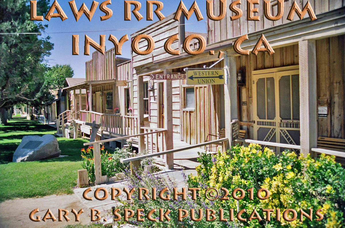
In
1883, a 20 x 74 depot
building was erected at BISHOP CREEK
STATION and a small town quickly grew up around the building. On February 26, 1887, a post office
opened its doors with George H. Hardy as the first postmaster. It remained in operation until June 30,
1963. BISHOP CREEK STATION boomed with the railroad, becoming a busy
shipping center for agricultural products and minerals being shipped from mines
in the region. Numerous businesses
popped up, including a barber, blacksmith shop, boarding house,
“eating” house, two general stores, hotel, pool and dance hall,
post office, powder magazine, rooming house and warehouses. An
old photo also shows a whitewashed, wooden school house.
In
1900, the Southern Pacific Railroad purchased the line, and renamed the station
LAWS,
after R.J. Laws, an assistant superintendent for the railroad. For a detailed history of the Carson & Colorado Railroad, see John
Hungerford's book The Slim Princess.
LAWS remained busy, as the trains carried mining products,
agricultural goods and passengers in and out of
However,
in the late 1950s, the Southern Pacific moved to close the remaining portion of
the narrow gauge between Laws and Keeler. In April 1960, the railroad closed, the
last train ran, and the “Slim Princess” passed into history as the
tracks were pulled and the line officially ceased to exist. Until it was completely abandoned, the LAWS to Keeler branch was
the last public-use, operational narrow gauge railroad in the American West.
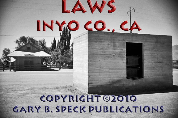
When
the railroad shut down, LAWS faded,
but didn’t quite die. During
the 1950s and 1960s, Huntley Industrial Minerals Company operated a kaolin, siltex, and pyrophyllite mill
here that processed those clays from nearby mines. The company also operated their
laboratory and company offices here.
The clay was milled, bagged and shipped from the plant, but after the
rail line closed, it had to be trucked. The clay was used on athletic fields,
in cement and paint pigments and extenders. The talc was used in talcum powder and
paper coatings.
After
the Southern Pacific shut down the rail line, they donated the station and some
rolling stock to the City of
Leaving LAWS, US 6 heads straight north up the wide valley and crosses the Inyo/Mono County line at MP 8.354. It then swings slightly to the
northwest, where the trees and buildings of CHALFANT beckon.
CHALFANT
Today, CHALFANT is a quiet, rural, residential
community located along the east side of US 6, about a mile north of the county
line, at an elevation of 4258’.
It consists of a collection of houses, a ball field and park, fire
station and a “modern” 1970s era tin-roofed, wood veneer-sided
market. In the late 1960s, the old
clapboard, false-fronted CHALFANT General
Store remained,
but has long since disappeared having been replaced by the nondescript,
architecturally less pleasing market that anchors the tiny town of 300 or so
folks. When the Carson & Colorado Railroad came through,
the siding established here was named after the Bishop newspaper
publisher W. A. “Willie” Chalfant. It was located along the old Carson & Colorado Railroad line
about a mile southeast of the roofless rock ruin at the south end of town, at
or near the powerhouse at the junction of Slim Princess/Chalfant
Loop/Piute Creek Rds. The post office opened in 1913, and is
no longer in operation.
About a quarter
mile north of CHALFANT between MP 13
and 14 are a couple rock-walled
ruins east
of the highway.
Somewhere between
here and the next stop at HAMMIL,
two small sidings were established along the Carson & Colorado Railroad. They were called DEHY and SHEALY, but I
have not determined their exact locations.
SHEALY was approximately six
miles north of CHALFANT, east of US
6, along the old railroad grade, PROBABLY just north of White Mountain Ranch
Road about four miles south of HAMMIL. DEHY,
about 7.5 miles north of CHALFANT,
1.5 miles north of SHEALY and 2.5
miles south of HAMMIL.
Coming up next is
the scattered ranching community of …
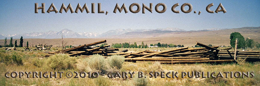
HAMMIL
HAMMIL shows no connection to its railroading past. It sits on the east side of US 6 at the
junction with
As
US 6 continues its northwesterly trend, the elevation rises slowly. Stop along the highway midway between HAMMIL and BENTON. Off to the
east, at the base of the
QUEEN
DICKS
This ghost ranch was located along Reichert Creek in
the White Mountains, 3.9 miles east of US 6 at a point 5.3 miles south of
Benton Station. This ranch was
established and operated by a Piute Indian named Queen Dick. He had established an extensive ranch in
the canyon, where he raised goats and planted crops. He constructed numerous rock walls, a
cabin, barn and other outbuildings, which have since collapsed. It is ONLY accessible by foot or via a
four-wheel-drive trail.
Continuing north, US 6 enters the little half-dead town of…
BENTON
Right in the heart of BENTON
is the junction with State Highway (SH) 120, which heads west towards Lee Vining and US 395.
Four miles west of this junction is the old silver mining town of BENTON HOT
SPRINGS. These two
little towns were featured as our Ghost Town of the Month in August 2008, so the details of these two towns are
available on our BENTON
page. Along
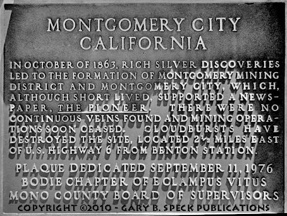
the east side of US 6 in the heart of
Like Queen DicKS (above), MONTGOMERY CITY is only accessible via
foot or a four-wheel-drive vehicle.
This 1860s era silver mining town is located on the west
slope of the White Mountains, in Montgomery Falls Creek Canyon, 2.7
miles due east of BENTON. It was a well-publicized, but very
short-lived mining camp, but never lived up to its billing and was wiped out by
a flashflood. When it was active,
only about $60,000 came from the
From BENTON,
US 6 swings to the northeast and seven miles later reaches the California/Nevada state line.
CONTINUED
in PART
2…
Part 1 – NEXT
PART 1: Bishop, CA to CA/NV State Line
PART
2: CA/NV State line to
PART
3: Tonopah to Warm Springs,
NV
PART
4: Warm Springs, NV to NV/UT State Line
PART
5: NV/UT State Line to the Tintic Mining District, UT
PART
6: The Tintic
Mining District to Price, UT
PART
7: Coal Mining Camps west of
Price, UT
GPS
and Standard Township/Range locations for the sites featured above.
|
SITE NAME |
ELEV. |
LATITUDE |
LONGITUDE |
TOWNSHIP/RANGE |
|
Benton
(Station) (Mono Co.) |
5387’ |
37.8190990 /
37° 49’
09” N |
-118.4765094 /
118° 28’
35” W |
W2 Sec 32, T1S,
R32E, MDM* (* Mount Diablo Base
Line & Meridian) |
|
Benton Hot Springs (Mono Co.) |
5630’ |
37.8002103 /
37° 48’
01” N |
-118.5290107 /
118° 31’
44” W |
SW3 Sec 2, T2S,
R31E, MDM |
|
Bishop
(Junction US 6/395) (Inyo Co.) |
4150’ |
37.374523 |
-118.395367 |
N-Ctr Sec 6, T7S, R33E MBM |
|
Chalfant (Valley) (Mono Co.) |
4258’ |
37.5293738 /
37° 31’
46” N |
-118.3634454 /
118° 21’
48” W |
NE3 Sec 8,
W½ Sec 9, T5S, R33E, MDM |
|
Chalfant Siding (Mono Co.) |
Approx 4200’ |
37.508177 Approx |
-118.348997 Approx |
SE3 Sec 16, T5S,
R33E, MDM Approx |
|
Dehy Siding (Mono Co.) |
Approx 4540’ |
37.643580 Approx |
-118.388178 Approx |
SE3 Sec 36, T3S,
R32E, MDM / Or SW3 Sec 31, T3S, R33E, MDM (approx) |
|
Hammil (Mono Co.) |
4593’ |
37.6785423 /
37° 40' 43"
N |
-118.4037274 /
118° 24' 13"
W |
NW3 Sec 24, T3S,
R32E, MDM |
|
Inyo/Mono County Line |
4216’ |
37.6785423 / 37° 27’
45” N |
-118.350048 / 118° 20’
58” W |
- |
|
Laws (Inyo
Co.) |
4117’ |
37.4007622 / 37°
24’ 03” N |
-118.3456639 / 118°
20’ 44” W |
NW3 Sec 27, T6S,
R33E, MDM |
|
Laws
– Railroad Museum (Inyo Co.) |
4118’ |
37.3993734 /
37° 23' 58"
N |
-118.3462195 /
118° 20' 46"
W |
NW3 Sec 27, T6S,
R33E, MDM |
|
Montgomery City (Mono Co.) |
6450’ |
37.8285428 /
37° 49' 43"
N |
-118.4309530 /
118° 25' 51"
W |
SE3 Sec 27, T1S,
R32E, MDM |
|
Queen Dicks (Mono
Co.) |
6201’ |
37.7638206 /
37° 45' 50"
N |
-118.4009508 /
118° 24' 03"
W |
NW3 Sec 24, T2S,
R32E, MDM |
|
Shealy (Mono Co.) |
Approx 4590’ |
37.620044 Approx |
-118.385475 Approx |
NW3 Sec 7, T4S,
R33E, MDM Approx |
|
State Line (CA/NV) |
5983’ |
37.901136 / 37°
54’ 04” N |
-118.435364 / 118°
26’ 06” W |
- |
|
Historians estimate that
there may be as many as 50,000 ghost towns scattered across the The Ghost Town
Guru's Guide
to the Ghost Towns of “STATE”™ These original guides
are designed for anybody interested in ghost towns. Whether you are a casual
tourist looking for a new and different place to visit, or a hard-core ghost
town researcher, these guides will be just right for you. With over 30 years
of research behind them, they will be a welcome addition to any ghost towner's library.
Thank you, and we'll see you out on the
Ghost Town Trail! For more information on
the ghost towns along this portion of E-mailers,
PLEASE NOTE: Due
to the tremendous amount of viruses, worms and “spam,” out there,
I no longer open or respond to e-mails with unsolicited attachments, OR
messages on the subject lines with “Hey”, “Hi”,
“Need help”, “Help Please”, “???”,
or blank subject lines, etc. If
you do send E-mail asking for information, or sharing information, PLEASE indicate the
appropriate location AND state name, or other topic on the
“subject” line. THANK
YOU! :o) |
IMPORTANT These listings and
historical vignettes of ghost towns, near-ghost towns and other historical
sites along this portion of US HIGHWAY 6 above are for informational
purposes only, and should NOT be construed to grant permission to trespass,
metal detect, relic or treasure hunt at any of the listed sites. If the reader of this
guide is a metal detector user and plans to use this guide to locate sites
for metal detecting or relic hunting, it is the READER'S responsibility to
obtain written permission from the legal property owners. Please be advised,
that any state or nationally owned sites will probably be off-limits to metal
detector use. Also be aware of any federal, state or local laws restricting
the same. When
you are exploring the ghost towns along Ghost Towner's
Code of Ethics. |
Also visit: Ghost Town
Home
Page | Site Map | Ghost Town Listings
| On
the Road Again | Photo Gallery
| Treasure
Legends
CURRENT Ghost Town of the
Month | PAST Ghost Towns
of the Month
Ghost Towner's
Code of Ethics | Publications | Genealogy
| License Plate
Collecting
A few LINKS to outside webpages:
Ghost
Towns | Treasure
Hunting | License
Plate Collecting | Genealogy
***
THIS PAGE
FIRST POSTED: January 4,
2010
***
This entire website, and all individual web pages
is
copyright
© 1998-2017
by Gary B Speck Publications
ALL rights reserved