ON THE ROAD AGAIN
With Ghost Town
A Tour Guide
to the Ghost Towns Along
From Bishop, California
to
Price, Utah
PART 7
Coal Mining Camps west of Price, Ut
CONTINUED
from PART
6…
Hidden in little parallel canyons off to
the west of the little string of towns between Helper and Price are a double
handful of old coal mining camp sites strung along the bottom of the
canyons. Having researched Spring
Canyon and Consumers Wash from some outdated ghost town books, I arrived here
with the expectation of seeing a string of abandoned towns with lots of
standing, haunting empty buildings fitting the stereotype of a ghost town. IF that is your intent, then you WILL be disappointed. However, tangible remains are very
generous, and dozens of interesting ruins remain of these dozen or so old coal
mining camps. I was shocked by what
I found – or didn’t find – BUT, I was far from being
disappointed. As I stated in my
September 2009 Ghost Town USA column
in Western
& Eastern Treasures magazine:
“I’d heard about the many standing buildings and the haunting
character of these towns. Like a
novice, I expected to see a chain of towns filled with still-standing buildings
just waiting for me to visit – neglecting to do any online research prior
to leaving. I also forgot to notice the copyright dates on the books! Time marches forward, untended buildings
fail, ghost towns fade away. I was
shocked at what I found; but I was NOT disappointed. Our beautiful string of pearls is now
battered and worn, filled with chipped and discolored gems. Others have broken and fallen off the
string. Yet, what does remain is well worth a visit.”
We’ll start our tour with Spring
Canyon.
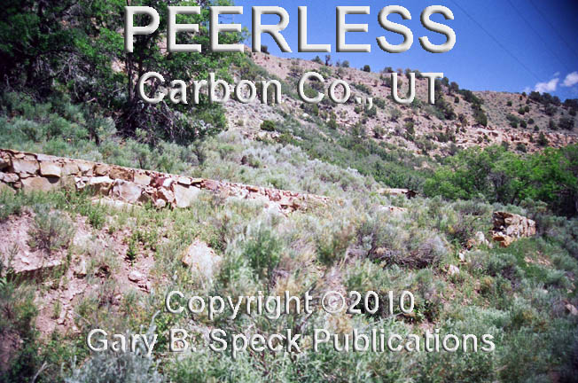
PEERLESS
Helper sits at the mouth of Spring Canyon,
so it is relatively easy to find.
Once threaded through the maze of roads, Spring Canyon Road reaches a
railroad bridge and the start of the journey up-canyon begins. Just 1.3 miles west of the bridge is the
scattered remnants of PEERLESS. The coal mine near here was operated by
the Peerless Coal Company, and the shipping town was named for it
(Surprised???) During its peak
years in the 1920s and 1930s, the population managed to reach around 300. This company town had all the amenities,
including housing, company offices and a clubhouse for company officials. Because it was so close to Helper, many
of the miners commuted from that larger town. For the non-commuters, there was the
ever-present company store, a pool hall, post office, saloon, school and 30
houses. The school closed in 1950
and the mine in 1953. Only rubble
and a few ruins
remain.
STORRS / SPRING CANYON
The next coal camp was located 1.2 miles
above PEERLESS. It sat a couple hundred yards north of
Spring Canyon Road, up Sowbelly Gulch.
The coal here was first mined by Jesse Knight to produce fuel for his Tintic
District mills. In 1912,
the Spring Canyon Coal Company-owned town was established and named STORRS, after a company official. Like his other towns, Knight allowed no
saloons or gambling dens. By 1914, STORRS consisted of 60 stone houses, a
church and school, hotel, stores, mine offices, and additional homes, enough to
house the population of 1000 or so.
Knight also built a railroad spur line from Helper to his camp.
Later, the Rio Grande Railroad added onto
the end of Knight’s line. The
Utah Railway also joined in rail building, and punched through to the end of
the canyon.
In 1924, the name of the camp was changed
to SPRING CANYON. And for the next
two decades remained a bustling town.
In 1940, some 300 people still lived here, and in 1946 production began
decreasing. In 1950 the population
began to drop, with only 250 folks remaining. By 1954 only a few miners remained, and
in 1969 the mine closed.
In George Thompson’s 1982 book, Some
Dreams Die – Utah’s Ghost Towns and Lost Treasures,
Thompson paints a picture of an impressive ghost town.
“Today,
Spring Canyon is one of the most impressive ghost towns the state has to offer,
with entire blocks of well built stone buildings still standing.
Scores
of businesses and rows of abandoned homes line the canyon bottom for a mile or
more.”
Things have really changed! About the only evidence a town ever
existed is the railroad grade and the foundation
and ruins of a structure on the northwest side of the canyon
junction. There was nothing else
visible.
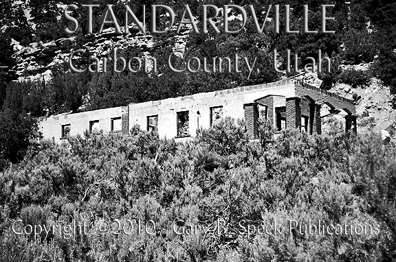
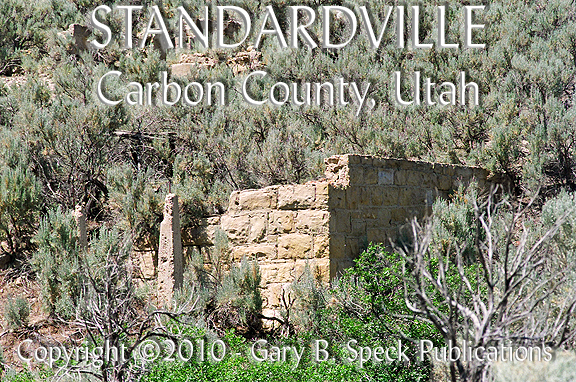
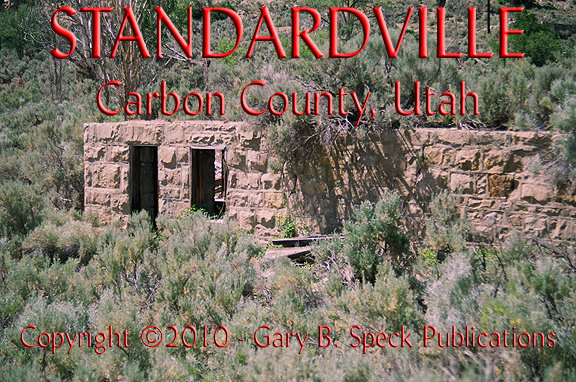
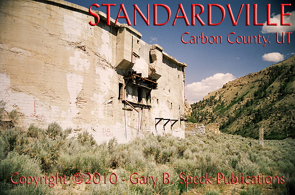
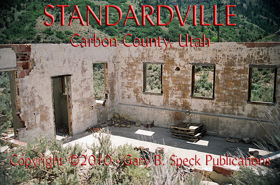
STANDARDVILLE
About a mile to
the west, at the junction of Spring Canyon/Gilson Gulch was the site of STANDARDVILLE. Here in 1912 another small coal camp got
started. In 1914 and the coming of
the railroad, STANDARDVILLE became a bustling mining and shipping center, seeing
as much as 1000 tons of coal a day pass through. A state-of-the-art company town was laid
out. It included architecturally
compatible lawns and landscaping, apartments, a barbershop, butcher shop,
general store, homes, hospital,
post office, recreation hall and a school.
Over 500 people lived here and during WWII, production increased to over
2000 tons of coal a day. After the
war ended the boom dissipated, and by 1950 the population had dropped in half
to 250 people. Shortly after, the
mines and the town’s main businesses all closed. By 1953, STANDARDVILLE was a
ghost town.
STANDARDVILLE in 2008 had
numerous ruins, BUT I’ve heard the site is now posted. If so, please abide by any signage and
view all ruins
from the roads. Dressed
rock and plaster-faced red-brick
walls remain of many of the buildings and a couple roofless ruins of
larger structures can also be seen.
A huge curved
concrete wall dominates the site.
This town has the most extensive
ruins of any of the other towns in the canyon.
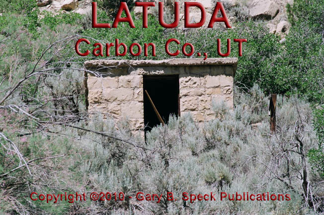
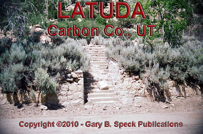
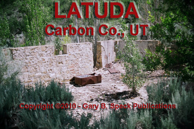
LIBERTY / LATUDA
Just a tad over a half mile further west is
the site of LIBERTY/LATUDA. It is located at the junction with
Robinson Gulch and named after the Liberty Coal Company. The Liberty Company opened the mine in
1914, followed by a second mine lower down in 1917. In 1918, a company-owned support camp
called LIBERTY was located at the
lower mine. During the 1920s, 35 additional houses were built, along with a
doctor, mine company office/ hotel, post office and school. A post office was applied for under the
name Liberty, which was turned down.
The last name of Frank Latuda, the owner of
the Liberty Coal Company was offered and accepted. LATUDA was a quiet camp of 300 to 400 people that also faded
after WWII ended. By 1950, only 100
folks remained. The mines here shut
down in 1954 and by the early 1960s only a few miners working at the Spring
Canyon Mine remained. By 1967 they were gone and the buildings moved elsewhere.
Today only the rubble of a rock-walled
dugout, steps
and a few foundations
remain.
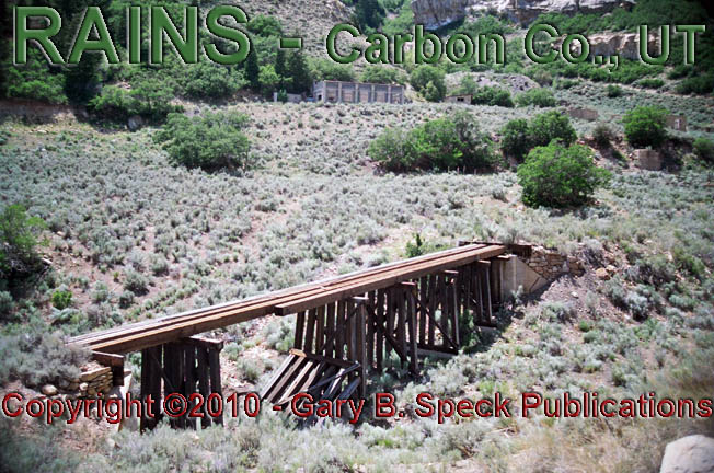
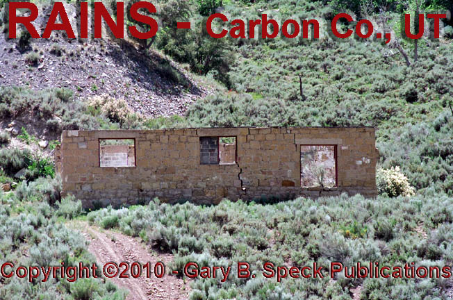
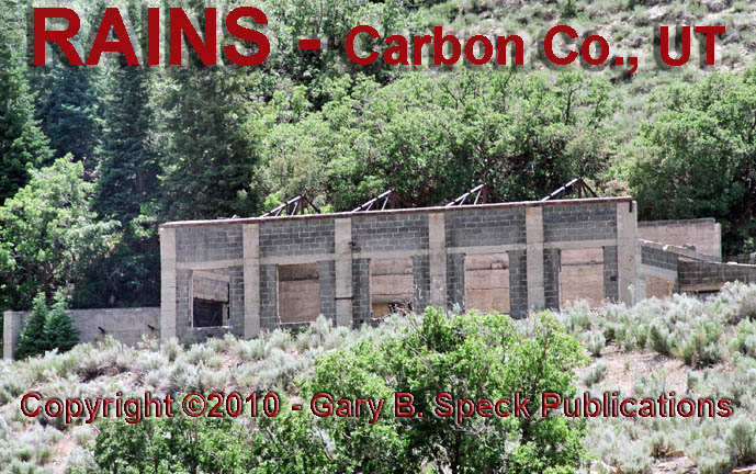
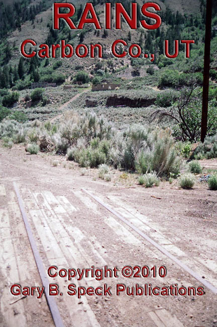
RAINS
RAINS is about a half mile
west of LATUDA at a fork in the
canyon. Here the coal veins were
18’ wide, the thickest, in the canyon. As a result, in 1915 L.F. Rains and the
Carbon Coal Company opened up a mine and established a company-owned mining
camp with its 60 houses lined up in a double row alongside the main road. The population reached 500, and those
folks were served by a boarding house, company store, post office and school.
However, despite the thickness of the coal vein, production waned by the late
1930s. In 1940, the population had
dropped to 400, but increased during WWII years, peaking in 1946. After the war
ended mining nearly ceased. In 1950
only 73 people remained to see the mine close completely in 1958. Some of the remains include an old wooden
train
trestle, and the roofless shells of a rock
and a concrete
block
building. The old railroad
line is still visible in the paved road on site.
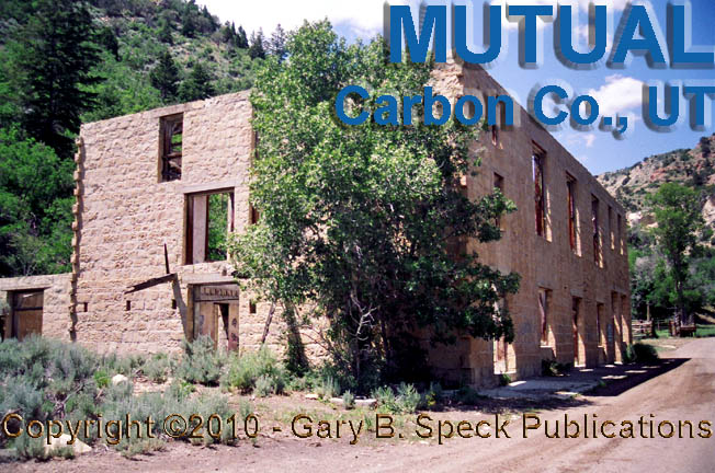
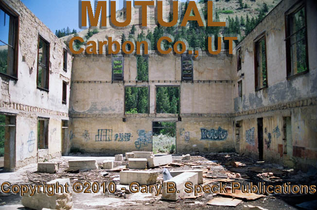
MUTUAL
Located in the North Fork of Spring Canyon
(Ciochetto Canyon), about a half mile north of and
adjacent to Rains was MUTUAL. The
Mutual Coal Company opened their mine and established their mining camp in 1921
but shut down in 1938. The town
supported about 250 residents, who also worked in nearby mines. Even though the
camp was small, it was home to the massive, cut stone company
store, which still stands as a roofless
shell. It remained open until 1954.
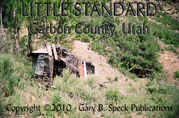
LITTLE STANDARD
Located
just south of RAINS at the mouth of
the South Fork of Spring Canyon was the coal camp of LITTLE STANDARD. It operated 1925-1938 and was nothing
more than a small tent camp with a 14-room (bed?) bunkhouse. When the nearby Mutual Mine shut down,
most of the tent-dwellers packed up and relocated to the empty cabins in MUTUAL. Nothing but a small
cabin, tumbled
wooden rubble and a rock
wall remain.
This is the end of Spring Canyon, so now
return to Helper and head south to the town of Spring Glen. Then head west, up
Consumers Wash. Unlike
Spring Canyon, there is an active coal mine in this canyon, and the huge coal
trucks aren’t looking for passenger vehicles so drive with caution. The road is narrow and has limited
visibility over much of the route.
3.2
miles west of Spring Glen and the junction of US 6/50 and the Consumers Wash
Road is a railroad crossing and a large coal shipping center. All mileages will be from this point.
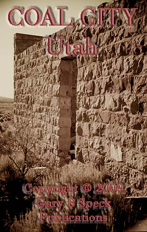
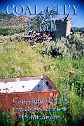
COAL
CITY
COAL CITY is not visible from the
main canyon road. At mile 5.1, a
short, poorly marked dirt road heads up a slight hill to the north and around a
small knob. Just a half mile in,
there is a wide parking area for a wildlife sanctuary. This is the site.
Visible
a couple hundred yards to the north, on
top of a slight rise, is the roofless ruin of one of the rock-walled
stores in what was once called COAL
CITY. Today, the town’s
remains are sparse but interesting.
There is a roofless cut-rock store
building, a pair of tumbled wooden piles of former residential
buildings. A scattering of smaller collapsed
wooden buildings and a topless rock-walled cistern/well also
remain. Be careful around it. A tumble here could prove to be a
day-ruining experience for you and whoever finds your remains!
Up
until the late 1970s, there were two store buildings. The of one is now just a barren scar of
scraped earth. The other still
stands solid, or at least did in July 2008.
The
story of COAL CITY dated to 1885
when it was a small agricultural community called Oak Spring Bench. A coal seam was discovered here in
October 1921, and the Great Western Coal Mines Company was incorporated. They
laid out a town which was going to be called GREAT WESTERN. Somehow it was christened COAL CITY instead.
In
1922, the Andreini and Calzani
building was built and used as offices for the Great Western Company. Three years later, Eugene Androni opened a store in the building. It is said that at this time, famed
World Champion boxer Jack Dempsey came to Coal City to do some fight
training. It’s also claimed
that the locals tried to get him to invest money in the town, and if he did
they’d rename the town DEMPSETVILLE
or DEMPSEY CITY after him. Apparently he didn’t bite at the
invitation.
The
mid-1920s saw much growth once the railroad arrived in 1923. A year later a log cabin school housing
24 students was built in 1925. A
year later a large concrete block school replaced it. 1927 saw a pair of block houses and the
Coal City Store and bakery opening.
Despite all the growth, bankruptcy dogged the parent company, and coal
mining stopped and started in fitful surges. The town’s dream of glory
died, and by 1930 only some 70 folks remained. By 1940 it was dead.
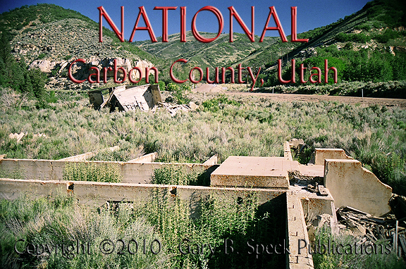
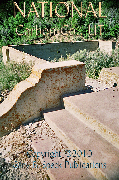
NATIONAL
Located
about 2.3 miles west of COAL CITY is
NATIONAL, the first of a trio of
related coal camps. The mines here
were discovered as early as 1908 but not developed until the 1920s. Ruins
of this old town sit south of the road, making exploring the site an
exercise in brushbusting, and pain management! Photos
from the 1970s show extensive ruins, but most of those ruins are either are
long gone of buried by thorned bushes. The National Coal Company operated the
mine and support camp here. This
was the largest of the three camps in the area and contained its own company
store, as well as a shared post office and school. The town faded and died by the late
1940s. Some of what remains
include: foundations of what may have been the company
store or offices, foundations
of an unidentified building and a collapsing
wood-frame building. Looking at
some of the details shows fancy concrete work along the steps
leading up into the largest ruin.
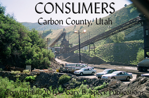
CONSUMERS
On
the west end of NATIONAL is a side
canyon heading the northwest. Just
over a quarter mile up the canyon is the site of Consumers. However, the site of the town has been
scraped clean and is now an active
coal mine. The old town sat
where today’s massive mine equipment now sits. The CONSUMERS
name is remembered in the canyon and the mine.
CONSUMERS began around the early
1920s and also had a company store.
The district hospital and an amusement hall were located here. It was originally called GIBSON, after Arthur Gibson, the
discoverer of the coal mine in 1921.
When the Consumers Mutual Coal Company took over, the name was changed.
In 1927, the Blue Blaze Coal Company purchased the mine and camp, continuing to
operate until 1938. Ownership
changed and mining was off and on until the 1950s.
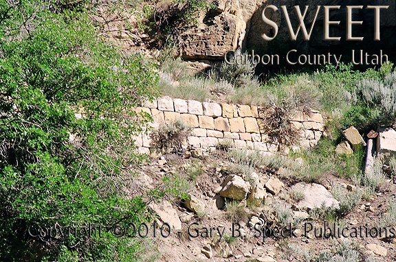
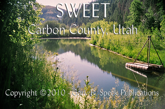
SWEET
West
of NATIONAL, up another canyon is the site of Sweet, of which very little
remains along the flat part of the canyon bottom. There is a gate at the mouth of the
canyon, but the sparse remains are about a quarter mile hike along a flat
canyon bottom road. I discovered a
couple rock
walls and some foundation pits near a small
reservoir, the remains of railroad
trestle supports and a few foundations.
This
early 1920s camp lasted until the early 1950s. The mines were discovered by William
Sweet and named after him. The
Gordon Creek Coal Company operated them, but in 1925, the company changed its
name to the Sweet Coal Company.
The maximum population reached about 200, and the camp had the company-owned
Sweet
Mercantile and a saloon. I have not
seen that claim in writing, but there are tokens known bearing the Sweet Mine
Beer Parlor name.
Again,
ownership was off and on until the 1950s when it all shut down for good. Almost
all the tangible evidence of a town was also removed.
This
is the end of our journey along US 6 between Bishop, CA and Price, UT. Someday soon, I’ll again hear the
siren call of this road, and continue this journey to the east. Until that happens, there are other
roads to explore and thousands of other ghost towns to photograph!
Keep the greasy side down and the shiny side
up. Happy journeys and we’ll
see you On the
Road Again!
END
PREVIOUS
– Part 7 – END
PART
1: Bishop, CA to CA/NV State Line
PART
2: CA/NV State line to
PART
3: Tonopah to Warm Springs,
NV
PART
4: Warm Springs, NV to NV/UT State Line
PART
5: NV/UT State Line to the Tintic Mining District, UT
PART
6: Tintic
Mining District to Price, UT
PART 7: Coal Mining Camps west of Price, UT
GPS
and Standard Township/Range locations for the sites featured above
|
SITE NAME |
ELEV. |
LATITUDE |
LONGITUDE |
TOWNSHIP/RANGE |
|
Coal City |
7132’ |
39.6666304 / 39° 40' 00" N |
-111.0162773 / 111° 00' 59" W |
SW¼ Sec 27, T13S, R8E, SLM (Salt Lake
Baseline and Meridian) |
|
Consumers |
8100’ |
39.7005185 / 39°42' 02" N |
-111.0626677 / 111° 03' 46" W |
NE¼ Sec 18, T13S, R8E, SLM |
|
Latuda |
6860’ |
39.7038521 / 39°42' 14" N |
-110.9459970 / 110° 56' 46" W |
SW3 Sec 8, T13S,
R9E, SLM |
|
Little Standard |
NOT
LISTED IN GNIS |
NOT
LISTED IN GNIS |
NOT SHOWN ON GNIS TOPO |
|
|
Mutual |
7333’ |
39.7144073 /
39° 42' 52"
N |
-110.9687754 /
110° 58' 08"
W |
NE3 Sec 12, T13S,
R8E, SLM |
|
National (NOT shown on GNIS,
is on Topo map) |
39.689290 |
-111.051693 |
S-Ctr Sec 17, T13S, R8E,
SLM |
|
|
Peerless |
6447’ |
39.6941301 /
39° 41' 39"
N |
-110.9109960 /
110° 54' 40"
W |
SE3 Sec 16, T13S,
R9E, SLM |
|
Rains |
7106’ |
39.7094074 /
39° 42' 34"
N |
-110.9632197 /
110° 57' 48"
W |
W-Ctr Sec 7, T13S, R9E, SLM |
|
Spring Canyon |
6634’ |
39.7038521 /
39° 42' 14"
N |
-110.9196073 /
110° 55' 11"
W |
S-Ctr Sec 9, T13S, R9E, SLM |
|
Standardville |
6739’ |
39.6999633 /
39° 42' 00"
N |
-110.9334966 /
110° 56' 01"
W |
NE¼
Sec 13, T13S, R9E, SLM |
|
Sweet (NOT shown on GNIS) |
|
39.689505 |
-111.056725 |
SW¼ Sec 17, T13S, R8E, SLM |
|
Historians estimate that
there may be as many as 50,000 ghost towns scattered across the The Ghost Town
Guru's Guide
to the Ghost Towns of “STATE”™ These original guides are
designed for anybody interested in ghost towns. Whether you are a casual
tourist looking for a new and different place to visit, or a hard-core ghost
town researcher, these guides will be just right for you. With over 30 years
of research behind them, they will be a welcome addition to any ghost towner's library.
Thank you, and we'll see you out on the Ghost Town Trail! For more information on
the ghost towns along this portion of E-mailers,
PLEASE NOTE: Due
to the tremendous amount of viruses, worms and “spam,” out there,
I no longer open or respond to e-mails with unsolicited attachments, OR
messages on the subject lines with “Hey”, “Hi”,
“Need help”, “Help Please”, “???”,
or blank subject lines, etc. If
you do send E-mail asking for information, or sharing information, PLEASE indicate the
appropriate location AND state name, or other topic on the
“subject” line. THANK
YOU! :o) |
IMPORTANT These listings and historical
vignettes of ghost towns, near-ghost towns and other historical sites along
this portion of US HIGHWAY 6 above are for informational purposes
only, and should NOT
be construed to grant permission to trespass, metal detect, relic or treasure
hunt at any of the listed sites. If the reader of this
guide is a metal detector user and plans to use this guide to locate sites
for metal detecting or relic hunting, it is the READER'S responsibility to
obtain written permission from the legal property owners. Please be advised,
that any state or nationally owned sites will probably be off-limits to metal
detector use. Also be aware of any federal, state or local laws restricting
the same. When
you are exploring the ghost towns along Ghost Towner's
Code of Ethics. |
Also visit: Ghost Town
Home
Page | Site Map | Ghost Town Listings
| On The Road Again | Photo Gallery
| Treasure
Legends
CURRENT Ghost Town of the
Month | PAST Ghost Towns
of the Month
Ghost Towner's
Code of Ethics | Publications | Genealogy
| License Plate
Collecting
A few LINKS to outside webpages:
Ghost
Towns | Treasure
Hunting | License
Plate Collecting | Genealogy
***
THIS PAGE
FIRST POSTED: August 06, 2010
***
This entire website, and all individual web pages
is
copyright
© 1998-2017
by Gary B Speck Publications
ALL rights reserved