Ghost Town
Guide to the Ghost Towns of
“The
Do you have Gary’s Ghost Town books?
Dust in the Wind - A Guide to
American Ghost Towns GHOST
TOWNS: Yesterday & TodayTM Become a friend of the book on Facebook ***
Return to Ghost Town USA’s State Listings
*** Visit Ghost Town USA’s Ghost Town of
the Month *** Visit Ghost Town USA’s Home Page *** Visit Ghost Town USA’s Photo Gallery *** Ghost
Town USA’s Site Map
*** Send E-mail to Ghost Town USA. *** Western & Eastern Treasures Ghost Town USA Column Index for Colorado |
Colorado probably has the second highest number
of ghost towns, near ghost towns and ghost town sites in the country (behind
California). In the high Rocky Mountains that bisect the state, thousands of
gold and silver mining camps were established from the late 1850s through the
early 1900s. Most were abandoned when the ores were exhausted, but a few
evolved into real towns and then faded. Many of these faded former mining
towns still beckon today's tourists as they are on or near main roads, and
therefore cling to life. Some of these old towns have turned into ski resorts
or have legalized gambling, and draw thousands of tourists a week to their
old saloons and new casinos. Others have restored or re-invigorated fading
downtowns and have active chambers of commerce. Some of these places include
Black Hawk, Breckenridge, Central City, Creede,
Cripple Creek, Georgetown, Leadville, Ouray, Silverton and Telluride. Yet
many hundreds of towns still remain with a small handful of people, dozens of
unoccupied buildings, and a general ghostly air about them. Down on the
eastern plains, agricultural and crossroads ghosts dot the map. Old forts,
stage and railroad stations, and cow towns rose and faded, and their remains
lie etched on the dusty landscape. On the Western Slope, uranium booms in the
late 1940s and early 1950s and oil shale in the late 1970s contributed boom
and bust cycles to that side of the mountains. Colorado
also has some of the best four-wheel drive scenery in the world, and many of
those "roads" are old mining trails or roads leading to nearly
forgotten old mining camps. When you visit Colorado, stop in any bookstore
and pick up a number of books about the state's ghost towns. Some of the best
are Robert Brown's series of three (Caxton Printers, Ltd. Caldwell,
ID). Also the pair of Colorado Ghost Town Atlas books by Leann Boyd &
Glenn Carson are indispensable (WH. Glenn Carson
Enterprises, Inc., Dona Ana, NM). With
well over 1000 ghost towns in CO, I have only listed a few herein. Some
of the vignettes below contain specific words that are listed on our DEFINITIONS
page. If you are unfamiliar with the
meaning of the word in a ghost town sense, click on the link and scroll down
to that term. You can use the BACK
button on the browser to return to this page. HELP! (NEW FEATURE)
Please check here to find a list of ghost towns that various contacts are
looking for. IF you have any
information on these places please e-mail me and I can respond back to those looking
for info on these ghosts. PLEASE NOTE: Where
photos are indicated on the subject line thusly (PHOTO!), please use your browser’s “BACK”
button to return to this page. I was
NOT able to add a back-link to the jpg image.
More photos will be added over time. |
ABARR
|
Yuma Co. |
On SH 59, 20 miles
south of ·
S Sec line 25/26, T2S, R48W, 6PM (Sixth
Principal Meridian & 40° Base
Line) ·
Latitude: 39.8505439 /
39° 51' 02" N ·
Longitude: -102.7071531
/ 102° 42' 26" W |
ANIMAS FORKS
|
San Juan Co. |
Former silver mining
town is a class C ghost located 4.4 miles north of Eureka, which is 9.5
miles northeast of Silverton. Four-Wheel-Drive-Road
ONLY. Was active from 1870s through early
1900s. Once had over 1000 people. This is
one of the towns featured in my newest book, GHOST
TOWNS: Yesterday & TodayTM. ·
NW¼ Sec 6, T42N, R7W, NMPM (New Mexico Prime
Meridian & Base Line) ·
Latitude:
37.9311070 / 37° 55' 52" N ·
Longitude: -107.5714483
/ 107° 34' 17" W |
AYER
|
Otero Co. |
This forgotten, early
20th Century railroad siding and post office is featured on our Exploring
US 350 page. |
BENT’S
OLD FORT
|
Otero Co. |
Located
just west of the county line, north of the Arkansas River and south of SH
194, eight miles northeast of La Junta, which is on US 50, 64 miles southeast
of See our BENT’S
OLD FORT page for additional details. |
BENTON
|
Otero Co. |
This
forgotten, early 20th Century railroad siding and post office is
featured on our Exploring
US 350 page. |
BESHOAR
|
Las Animas Co. |
This
forgotten, early 20th Century railroad siding and post office is
featured on our Exploring
US 350 page. |
BLOOM
|
Otero Co. |
In
2005, this early 20th Century ghost town still had a roofless
building shell and cemetery. It is
featured on our Exploring
US 350 page. |
BOGGSVILLE
|
Bent Co. |
This class C
cattle town is just off SH 101, three miles south of Las Animas and east of
the ·
SW¼ Sec 14, T23S, R52W, 6PM ·
Latitude: 38.0416738 /
38° 02' 30" N ·
Longitude: -103.2127079
/ 103° 12' 46" W |
BUCKSKIN JOE
|
Park Co. |
On north side of
Buckskin Creek, two miles west of ·
SE¼ Sec 3, T9S, R78W, 6PM ·
Latitude: 39.2930449 /
39° 17' 35" N ·
Longitude: -106.0880751
/ 106° 05' 17" W |
CADDOA
|
Bent Co. |
Along the SECOND SITE: ·
Ctr (Center) Sec 13, T23S, R50W, 6PM ·
Latitude: 38.0477853 /
38° 02' 52" N ·
Longitude: -102.9660347
/ 102° 57' 58" W |
|
Gunnison Co. |
500 people once lived
in this 1880s silver-mining town located five miles east of Marble, which is
7.3 miles southeast of SH 133 at a point 4.1 miles south of Redstone. ·
NE¼ Sec 33, T11S, R87W, 6PM ·
Latitude: 39.0591557 /
39° 03' 33" N ·
Longitude: -107.1011585
/ 107° 06' 04" W |
DELHI
|
Las Animas Co. |
In 2005, this early 20th
Century ghost town still had several standing buildings. It is featured on our Exploring
US 350 page. |
EARL
|
Las Animas Co. |
This forgotten, early
20th Century railroad siding and post office is featured on our Exploring
US 350 page. |
EASTONVILLE
|
El Paso Co. |
This former potato
farming center is located on Sweet Road, ¾ mile west of SH 217, 12 miles
south of Elbert, at the north end of the county about 20 AIR miles northeast
of Colorado Springs. It is claimed to have once had 500 people. The post
office opened in 1872 and closed in 1932. ·
S-Ctr Sec 28,
T11S, R64W, 6PM ·
Latitude: 39.0611029 /
39° 03' 40" N ·
Longitude: -104.5621927
/ 104° 33' 44" W |
|
San Juan Co. |
This class D gold-mining
town dates to the 1870s, when it had 2000 people. Located on SH 110 (4 x 4 road only), 8.5 miles northeast
of Silverton. ·
S -Ctr Sec 19,
T42N, R7W, NMPM ·
Latitude: 37.8797187 /
37° 52' 47" N ·
Longitude: -107.5550594
/ 107° 33' 54" W |
FLORESTA
|
Gunnison Co. |
This old ghost town is
located on the north side of Ohio Pass, about two miles west of CR 730 (Ohio
Pass Rd.), 0.5 miles south of Kebler Pass
Road. It had a summer post office
1906-1919. ·
N-Ctr Sec 16,
T14S, R87W, 6PM ·
Latitude: 38.8419375 /
38° 50' 31" N ·
Longitude: -107.1228269
/ 107° 07' 22" W |
|
FULFORD |
Eagle Co. |
Lower...10.6
miles east of Upper...The
business section of town ·
S½ Sec line 23/24, T6S, R83W, 6PM ·
Latitude: 39.5149852 /
39° 30' 54" N ·
Longitude: -106.6564233
/ 106° 39' 23" W |
|
|
Clear Creek Co. |
County seat for See our Georgetown
page for additional details. |
|
|
San Juan Co. |
This company-owned
silver-mining town was active from 1878-1910 and once had nearly 2000 people.
7.1 miles north of Silverton on Cement Creek. ·
Corner Secs 16,
17, 20, 21, T42N, R8W, NMPM ·
Latitude: 37.8902735 /
37° 53' 25" N ·
Longitude: -107.6503383
/ 107° 39' 01" W |
GOTHIC
|
Gunnison Co. |
On the East River
Road, 8.2 miles north of Crested Butte on the east side of the East
River. Early 1880s boomtown with a
peak population near 8000. ·
N-Ctr Sec 3, T12S,
R86W, 6PM ·
Latitude: 38.9591580 / 38°
57' 33" N ·
Longitude: -106.9897676
/ 106° 59' 23" W |
HAHN’S PEAK
|
Routt Co. |
On east shore of
Steamboat Lake, seven miles north of Clark and 26.2 miles north of Steamboat
Springs. 1864s era gold-mining camp and county seat. It remained the county seat
until 1912. ·
SE¼ Sec 20, T10S, R85W, 6PM ·
Latitude: 40.8069152 /
40° 48' 25" N ·
Longitude: -106.9436613
/ 106° 56' 37" W |
HASTINGS
|
QUESTION - “Can anyone tell me about the old ghost towns of Hastings
and CATSKILL, CO? My g‑grandmother was born April 13, 1890 in Hastings,
Colorado; and many of her siblings were born in Catskill, Colorado.” Submitted by Marcy (April 03, 2002) Answer - “Didn't have time to find Catskill but it may have been somewhere
in the vicinity. Check out the Trinidad website also. Hastings was a small
town just outside Trinidad, and the site of a coal mining camp operated by
the Victor Coal Company (later the Victor ‑ American Fuel Company). Submitted by Priscilla Arnett (April 03, 2002) GNIS lists the Hastings Mine just 200 yards north of CR 44, in Canyon
del Diablo, about two miles west of Ludlow, which is on the railroad a mile
west of I-25 at EXIT 27, about 13 AIR miles northwest of Trinidad. (GBS) I believe the CATSKILL
asked about is actually CATSKILL, NM. That town was located in Colfax Co., and
had a post office 1890-1905. When it was
discontinued, the mail was delivered via Sopris,
CO. Catskill was located along the
railroad in the Canadian River Canyon, 3.7 AIR miles south of the state line,
20.5 AIR miles west of I-25 at Raton (NM), and 29.4 AIR miles southwest of
Hastings. This is probably the location
indicated above. …SEE the Catskill vignette on the New Mexico
page. HASTINGS: ·
SE¼ Sec 20,
T10S, R85W, 6PM ·
Latitude: 37.3380716 / 37° 20' 17" N ·
Longitude: -104.6191522 / 104° 37' 09" W CATSKILL (NM): ·
T20N, R31E,
New Mexico Principal Meridian & Base Line ·
Latitude: 36.9397479 / 36° 56' 23" N ·
Longitude: -104.8072162 / 104° 48' 26" W |
|
HESTER
|
Crowley Co. |
“I dug a Hester, Colorado beer today in Charlottesville,
Virginia. I find no reference to that
town anywhere. All it says on the bottle ‘Hester Colo.’ Any info?” Eric (January 25, 2004) Hester was a rural post office (and obviously also a
brewery) about 15 miles north of Ordway. The post office was active 1905-1912.
Crowley County is located on the plains east of Pueblo. It is not listed in GNIS (GBS). |
HORSESHOE
|
Park Co. |
An 1880s silver-mining
town. Its peak population reached 800. It was on Fourmile
Creek, about five miles west-southwest of Fairplay,
which is at the northern junction of US 285/SH 9. ·
SW¼ Sec 2, T10S, R78W, 6PM ·
Latitude: 39.2038796 /
39° 12' 14" N ·
Longitude: -106.0852966
/ 106° 05' 07" W |
HOUGHTON
|
Las Animas Co. |
In 2005, this was a
barren site and is featured on our Exploring
US 350 page. |
|
Pitkin Co. |
Also known as Belden, Chipita, Farwell, Mammoth City, Mount Hope, Sidney
and Spark Hill, this old mining
town is located on the bottom of the “big smile” of SH 82, 15 miles east of
Aspen, and just west of Independence Pass. At its peak, some 2000 people
walked the streets of this 1880s gold mining town. ·
Sec 10, T11S, R82W, 6PM ·
Latitude: 39.1072124 / 39° 06' 26" N
·
Longitude: -106.6058652 / 106° 36'
21" W |
KADREW
|
Las Animas Co. |
This forgotten, early 20th Century railroad
siding is featured on our Exploring
US 350 page. |
KEOTA
|
Weld Co. |
Established in 1888, this town once had a
school, church, fire station, bank, five stores, a hotel and a bustling
railroad station. It is located about 40 miles northeast of ·
NE¼ Sec 33, T11S, R87W, 6PM ·
Latitude: 39.0591557 /
39° 03' 33" N ·
Longitude: -107.1011585
/ 107° 06' 04" W |
|
Las Animas Co. |
“Site of coal miner's strike (1913-1914) and subsequent
slaughter of wives and children of the strikers. Remains of mining town nearby as well as a
monument explaining the event, which sits atop of the basement where some
women and children were killed.” Contributed by Stacey Cornwell (12/10/2001) ·
N-Ctr Sec 20,
T31S, R64W, 6PM ·
Latitude: 37.3333493 /
37° 20' 00" N ·
Longitude: -104.5833180
/ 104° 35’ 00" W |
MINDEMAN
|
Otero Co. |
This forgotten, early
20th Century railroad siding and post office is featured on our Exploring
US 350 page. |
MODEL
|
Las Animas Co. |
In 2005, this early 20th
Century ghost town still had several standing buildings. It is featured on our Exploring
US 350 page. |
|
|
Gunnison Co. |
On CR 744, at the junction of Doctor and Spring
Gulches, eight miles north of Spring Creek Turnoff off CR 742 (Taylor River
Rd.) Not listed in GNIS |
|
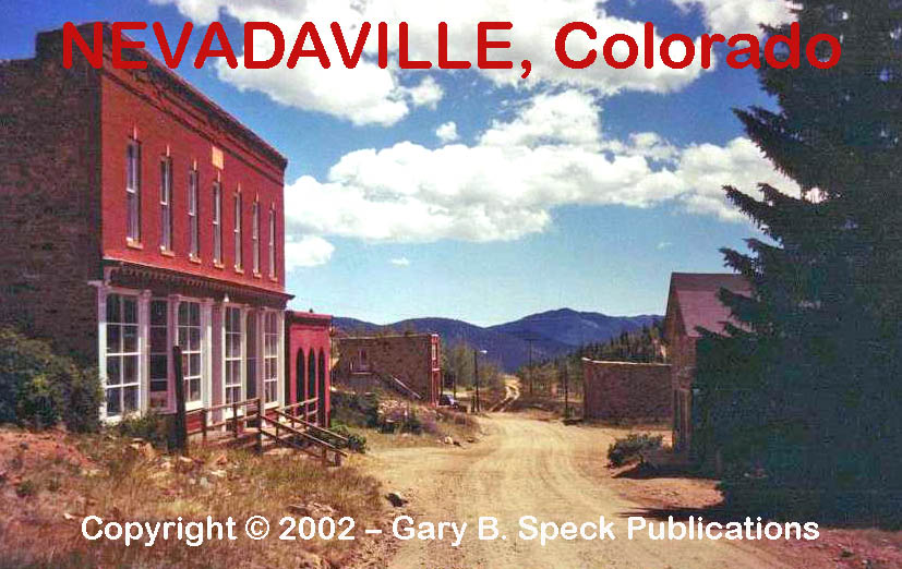
NEVADAVILLE |
Gilpin Co. |
Located above Central City/Blackhawk. It is a wonderful little class D
ghost with a half dozen buildings still standing. PHOTO! This is
one of the towns featured in my newest book, GHOST
TOWNS: Yesterday & TodayTM. ·
SW¼ Sec 11, NW¼ Sec 14, T3S, R73W, 6PM ·
Latitude: 39.7952656 /
39° 47' 43" N ·
Longitude: -105.5324978
/ 105° 31' 57" W |
|
|
Gunnison Co. |
On CR 765, 12 miles east of ·
N-Ctr Sec 26,
T50N, R3E, NMPM ·
Latitude: 38.5666602 /
38° 34' 00" N ·
Longitude: -106.6116988
/ 106° 36' 42" W |
|
ORMEGA |
Otero Co. |
This forgotten, early
20th Century railroad siding and post office is featured on our Exploring
US 350 page. |
|
|
Lincoln Co. |
At the junction of SH
94/71, at the west end of the county, near southeast tip of ·
SWC (SW Corner) Sec 5, SEC Sec 6, NEC Sec 7, NWC Sec 8, T14S, R56W, 6PM ·
Latitude: 38.8519383 /
38° 51' 07" N ·
Longitude: -103.7005037
/ 103° 43' 02" W |
|
|
Ouray Co. |
This class B
silver mining town is located 0.4 miles east of US 550, on the north side of
Red Mountain Pass, between Ouray and Silverton. At one time this town had
over 10,000 people and 100 plus business establishments. 4 X 4 road
only. ·
NW¼ Sec 13, T42N, R8W, NMPM ·
Latitude: 37.9036062 /
37° 54' 13" N ·
Longitude: -107.7025610
/ 107° 42' 09" W |
|
RENE |
Otero Co. |
This forgotten, early
20th Century railroad siding and post office is featured on our Exploring
US 350 page. |
|
SILVERTON |
San Juan Co. |
Silverton is a wonderful class E location and still-active county seat. However, it’s
population is much less than it was during its boom years in the 1875-1893
era. This is one of the towns featured in my newest book, GHOST
TOWNS: Yesterday & TodayTM. ·
W½ Sec 17, T41N, R7W, NMPM ·
Latitude: 37.8119410 /
37° 48' 43" N ·
Longitude: -107.6645057
/ 107° 39' 52" W |
|
SIMPSON |
Las Animas Co. |
In 2005, this early 20th
Century ghost town still had rubble and ruins. It is featured on our Exploring
US 350 page. |
|
|
Chaffee Co. |
A class D gold-mining
town located at the west end of SH 162, 16.5 miles west of US 285 at Nathrop. This is one of my favorite See our St.
Elmo page for additional details. This is
one of the towns featured in my newest book, GHOST
TOWNS: Yesterday & TodayTM. |
|
|
Baca Co. |
The first site is a Class A ghost
located six miles southwest of the present townlet,
west of the Kansas border, along the north side of the South Fork of the
Cimarron River. APPROXIMATE: ·
Sec 25, 26, 35, T32S, R44W, 6PM ·
Latitude: 37.2245877 ·
Longitude: -102.2269249 The present town is at its second site and is a Class D
agricultural town eight miles west of the Kansas border, and about eight
miles southeast of Walsh. It sits on
all four corners of the junction, but mostly on the southwestern corner of
the junction of CR 49/X. The town relocated here in 1909. ·
NEC Sec 6,
NWC Sec 5, T32S, R43W, 6PM ·
SEC Sec 31, SWC Sec 32, T31S, R43W, 6PM ·
Latitude: 37.2936295 / 37° 17'
37" N ·
Longitude: -102.1874017 /
102° 11' 15" W |
|
THATCHER |
Las Animas Co. |
In 2005, this early 20th
Century ghost town still had several standing buildings. It is featured on our Exploring
US 350 page. |
|
TIMPAS |
Otero Co. |
In 2005, this early 20th
Century ghost town still had several standing buildings. It is featured on our Exploring
US 350 page. |
|
TINCUP |
Gunnison Co. |
Class D
silver-boom town dating to the 1880s. Once had 6000 people. Located at the
junction of CR 765 (Grand Ave)/267 (Washington St), 18 miles north of Pitkin,
which is 27.2 miles east-northeast of Gunnison. Now popular with summer
visitors. ·
T15S, R82W, 6PM (Sections
not shown on GNIS) ·
Latitude: 38.7544393 /
38° 45' 16" N ·
Longitude: -106.4783605
/ 106° 28' 42" W |
|
TYRONE |
Las Animas Co. |
In 2005, this early 20th
Century ghost town still had several standing buildings. It is featured on our Exploring
US 350 page. |
|
|
Yuma Co. |
Established in the
1890s, this rural post office and crossroads community is located at the
southeast corner of CR CC/26, four miles west of US 385, at a point eight
miles south of Wray. It sits about eight miles northwest of the site of a
famous 1868 Indian/white battle. ·
NWC Sec 28, T1S, R44W, 6PM ·
Latitude: 39.9463790 / 39° 56'
47" N ·
Longitude: -102.3154743
/ 102° 18' 56" W |
WHITE PINE
|
Gunnison Co. |
1880s era placer
gold-mining camp with a peak population of 3000. Is located on CR 888, three
miles north of Crosden, in Tomichi Creek Canyon,
between Monarch and Cumberland Passes. ·
Ctr Sec 34, T50N, R5E, NMPM ·
Latitude: 38.5416626 /
38° 32' 30" N ·
Longitude: -106.3936374
/ 106° 23' 37" W |
In the
southeastern corner of the state a batch of ghost towns lie along US
Highway 350. These ghost towns were our featured Ghost
Town of the Month for March/April 2013.
MORE INFORMATION
|
Historians estimate that there may be as many as
50,000 ghost towns scattered across the The Ghost Town
Guru's Guide to the Ghost Towns of “STATE”™ These original guides are designed for anybody
interested in ghost towns. Whether you are a casual tourist looking for a new
and different place to visit, or a hard-core ghost town researcher, these guides
will be just right for you. With over 30 years of research behind them, they
will be a welcome addition to any ghost towner's
library. Thank
you, and we'll see you out on the Ghost Town Trail! For
more information on the ghost towns of COLORADO, contact us at Ghost
Town USA. E-mailers, PLEASE NOTE: Due
to the tremendous amount of viruses, worms and “spam,” out there, I no longer
open or respond to e-mails with unsolicited attachments, OR messages on the subject
lines with “Hey”, “Hi”, “Need help”, “Help Please”,
“???”, or blank subject lines, etc.
If you do send E-mail asking for information, or sharing information, PLEASE indicate the appropriate location AND state name, or other topic on the
“subject” line. THANK
YOU! :o) |
IMPORTANT These listings and historical vignettes of ghost
towns, near-ghost towns and other historical sites in STATE above are
for informational purposes only, and should NOT
be construed to grant permission to trespass, metal detect, relic or treasure
hunt at any of the listed sites. If the reader of this guide is a metal detector
user and plans to use this guide to locate sites for metal detecting or relic
hunting, it is the READER'S
responsibility to obtain written permission from the legal property owners.
Please be advised, that any state or nationally owned sites will probably be
off-limits to metal detector use. Also be aware of any federal, state or
local laws restricting the same. When you are exploring the ghost towns of STATE,
please abide by the Ghost Towner's
Code of Ethics. |
Also visit: Ghost Town
Home
Page | Site Map | Ghost Town Listings
| On The Road Again | Photo Gallery
| Treasure
Legends
CURRENT Ghost Town of the
Month | PAST Ghost Towns
of the Month
Ghost Towner's
Code of Ethics | Publications | Genealogy
| License Plate
Collecting
A few LINKS to outside webpages:
Ghost
Towns | Treasure
Hunting | License Plate
Collecting | Genealogy
***
THIS PAGE
FIRST POSTED: January 1999
***
This entire website, and all individual web pages
is
copyright
© 1998-2015
by Gary B Speck Publications
ALL rights
reserved