BENT’S OLD FORT, Otero County, CO
By
BENT’S
OLD FORT is one of those
fascinating historical places that all ghost towners should
visit. It is not a ghost town in the
purist’s sense of the word, but it definitely falls into our definition of a ghost town. In early July 2005, Ghost Town USA took a
giant step back in time at this historic old frontier trading post. A few wisps of puffy white clouds decorated
an otherwise perfectly blue sky. Warm
morning sunshine glowed against the creamy-colored adobe
walls of the trading post, tracing uneven patterns of light and shadow
across the uneven plastered surface. The
clean, damp smell of the Arkansas River and faint aroma of wet grass and wood
smoke wafted across the dry grass lining the trail where puffs of dust
enveloped our boots. The serenading songs of hundreds of unseen birds in the
cottonwood trees lining the riverbank neutralized the incessant buzz and nasty
bites of a swarm of large black flies. A burly, bearded man, whose long, unruly
hair was covered with a battered felt hat and carrying
a huge-bladed axe exited the heavy, wooden front gate, strolling slowly towards
large pile of split logs. His
long-sleeved white shirt stood in sharp contrast to faded denims and red vest.
Looking up he greeted us with a warm smile and friendly hello. “Welcome
to Bent’s Fort.”
We jumped 160 years from the 21st century, to the
early 1840s. Established by Charles and William Bent and Ceran
St. Vrain, Bent’s Old Fort was THE commercial
and cultural crossroads on the Santa Fe Trail and Arkansas River from
1833-1849. It is located on the north side of the Arkansas River and just south
of State Highway (SH) 194, some eight miles northeast of La Junta in the
once-wild plains of Colorado’s southeastern corner. This fur-trading post and frontier settlement
has been accurately on the site of the original.
Charles & William Bent were fur trappers and traders, and in
1830 joined forces with Ceran St. Vrain
ship in Santa Fe. Charles Bent also captained wagon trains on the
Missouri-Santa Fe route. St. Vrain sold their goods in Santa Fe and obtained the silver
and furs that Bent ran back to Missouri to obtain more trade goods to sell in
New Mexico. They also opened a store in
Taos and in Santa Fe, solidifying their importance in the trade market. Expanding to the north, the Bents and St. Vrain established a small trading post near where Pueblo,
Colorado now is. This post was too far
from the active buffalo hunting grounds further down along the Arkansas River,
so in 1833, they relocated to a spot along river and the Santa Fe Trail. They built a fur-trading post out of adobe
mud bricks to fortify it against any depredations from the local Native
Americans. They finished the fort a year
later and called it Fort William. It was
more popularly called Bent’s Fort.
The Bent, St. Vrain Company’s empire
was based on trading with the Southern Cheyenne and Arapaho peoples, to whom
they bartered trade goods for beaver and buffalo pelts. St. Vrain and the
Bents were fair to, and maintained good relations with both the Arapaho and
Cheyenne. The Bents and St. Vrain would trade both at the fort and at the various
Indian villages. They even extended
their reach and traded with other Indian nations, including the Blackfeet, Comanches, Gros Ventres, Kiowas, Lakota Sioux,
Plains Apaches and Utes; all of whom lived and hunted
outside the area immediately served by the fort.
They generally trade about 25 cents worth of trade goods for one
buffalo robe, which they could sell in Missouri for five or six dollars. They
traded items such as beads, blankets, brass wire, butcher knives, camp kettles,
guns, iron and tobacco for the buffalo pelts, which were then pressed into
bales of ten robes, and shipped by wagon to St. Louis. In 1840 alone, they delivered 15,000 buffalo
robes.
In addition to serving as the economic focus for a growing trade
empire, this privately owned, adobe–walled fort was the only American outpost
in the entire region. It was 275 miles
northeast of Santa Fe, and 530 miles west of Independence, Missouri. As its importance grew, it supplied
much-needed goods, services and camaraderie for travelers on the Santa Fe
Trail, as well as traveling army troops and explorers poking around in the
mountains to the west. During the summer
of 1846, the fort was visited by Colonel Stephen Kearney’s 1600-member “Army of
the West” on its way to campaigns during the Mexican-American War of 1846. After Kearney captured Santa Fe, Charles Bent
was chosen to be territorial governor.
Unfortunately only a few months later in January 1847, he was killed by
an angry mob in Taos.
The fort’s population consisted of an average of 40-60
employees, but could reach 100. As trust
developed between the Fort’s occupants and the local Native Americans, the
exterior trade window was used less, and the locals were allowed inside the
fort’s walls to trade their goods inside the trade
room. This was almost unheard of
on the American Frontier, and shows the high regard with which the post was
held by the locals.
By 1849 the fort’s prosperity began to wane with a decline in
trading and the death of Charles two years previously. St. Vrain
and William Bent finally abandoned the fort.
One source claims Bent blew it up.
Another says he burned it. In any
case, a few years later William established a new post at what was known as Big
Timbers, which is located near today’s Lamar, Colorado, some 30 miles east of
the old fort. The old fort hadn’t been totally destroyed and was used off and
on until the 1870s. But by 1918 it was
not much more than a memory.
Bent’s New Fort was built of stone and was in use from about
1852 until 1860 at which time it was leased to the United States Army and
renamed Fort Fauntleroy, and later, Fort Wise (1859), Fort Lyon (1860), and
finally abandoned in 1866.
On June 3, 1960, the site of Bent’s Old Fort was added to the
roster of National Historic Sites and within a few years reconstruction began
based on contemporary descriptions from diaries, paintings and archeological
evidence. One of the most valuable of
these resources was a set of detailed drawings of the post made by Army Lt.
James Abert in 1846.
Abert was a member of the United States
Topographical Engineers and made detailed drawings of the post during his brief
stay at the post.
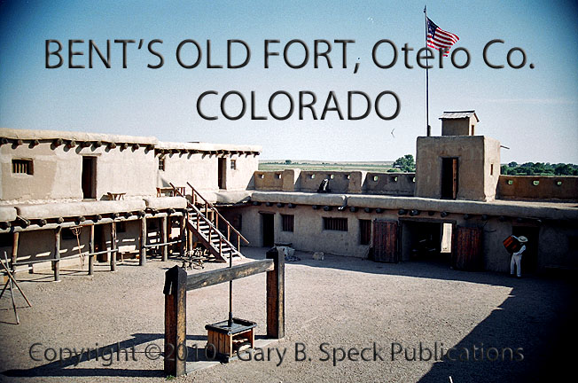
The fort is accurately rebuilt of heavy wood beams and adobe
bricks all plastered over with a thin adobe plaster. The ground floor is laid out in a square
surrounded by business related rooms, while the second level consists mostly of
staff and visitor’s quarters, along with a billiard room. The walls of the post are laid out in a
trapezoid shape with elevated bastions on the northwest and southeast
corners. From these bastions, all parts of the exterior wall are
visible. Each bastion was also armed
with a small cannon.
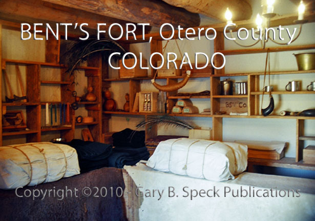
During its peak in the late 1830s and early 1840s, the fort was
a small, self-contained city consisting of a blacksmith, carpenter shops, gunsmith
and trading store (which also sold goods to travelers). Quarters were also here for staff and guests,
a kitchen and dining room served them meals and council rooms aided the trading
post staff to palaver with visiting traders.
Upstairs, a billiard room provided needed diversion for guests and
residents alike. Corrals, storerooms,
wagon room and a fur press all aided in making this a real community.
A visit to Bent’s Old Fort is treading in the footsteps of
history. Rededicated in 1976 for the
National Bicentennial celebrations, this old post has been fully and carefully
reconstructed, and is staffed with “living history interpreters;” National Park
Service personnel who are well versed in the post’s history and wear authentic
period costumes. Visitors can even
pretend they’re traders by visiting the trade room and bookstore where
“historically authentic reproduction trade goods” (Huh?) and books can be
traded for silver and green paper.
This old
historic fur-trading post is well worth a visit.
This was our Ghost
Town of the Month for October
2010.
LOCATION:
· NE¼
of NW¼ Sec 23, T23S, R54W, 6th
Principal Meridian & 40° Base Line
· Latitude:
38.0409410 / 38°
02’ 27” N
· Longitude: -103.4296310 / 103° 25’ 47” W
***************
Visit Ghost Town USA’s COLORADO
Ghost Town Pages
Also visit: Ghost Town USA’s
Home
Page | Site Map | Ghost Town Listings
| On The Road Again | Photo Gallery
| Treasure
Legends
CURRENT Ghost Town of the
Month | PAST Ghost Towns
of the Month
Ghost Towner's
Code of Ethics | Publications | Genealogy
| License Plate
Collecting
A few LINKS to outside webpages:
Ghost
Towns | Treasure
Hunting | License Plate
Collecting | Genealogy
***

***
THIS PAGE
FIRST POSTED: October 10, 2010
LAST UPDATED: November 03, 2010
**************
This
website and all information posted here-in is
copyright
© 1998-2015
by Gary B Speck Publications
ALL rights reserved