Penwell
Ector County, TX
By
Gary B. Speck
ALL I CAN SAY about
the fascinating
remains of
a post-boom oil town is WOW. When I pulled off of eastbound Interstate 20 and
dropped into this class D near-ghost on July 5, 2010, I was
thankful for serendipity. I didn’t have this place marked, and it was a
completely random stop, as I had been drinking a lot of ice tea all morning and
needed to “de-water.” So, as I coasted to a stop at the bottom of the EXIT 101
eastbound ramp, personal discomfort disappeared as the beginning of an
hour-long adventure with a nearly dead town was about to begin. We hit the
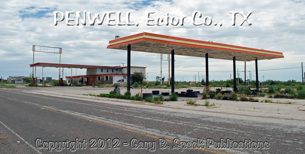
jackpot! Along the south side of the exit ramp a large
gas station/restaurant/automotive
repair
complex sat abandoned, its faded, peeling
truck mural semi-hidden
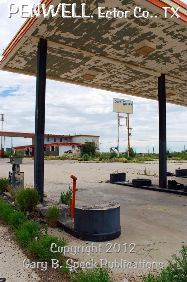
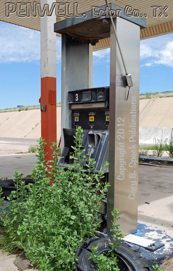
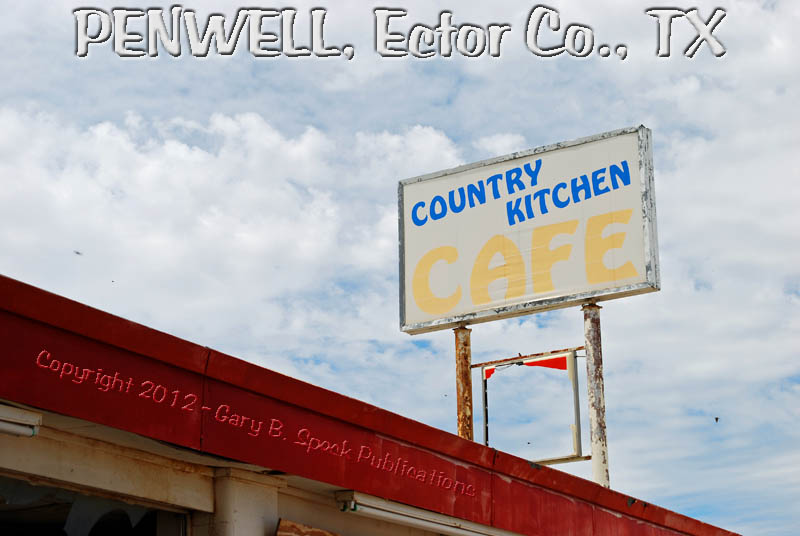
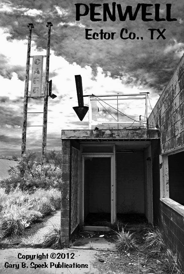
from view of the offramp. The five
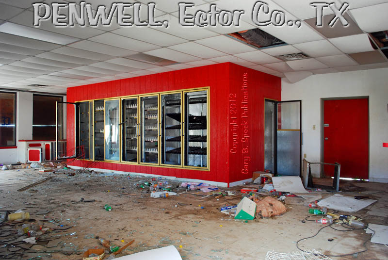
island gas station and Country
Kitchen Café with its two gas islands still mounted with
gas
pumps, restaurant and convenience
store with its bright
red chillers and a
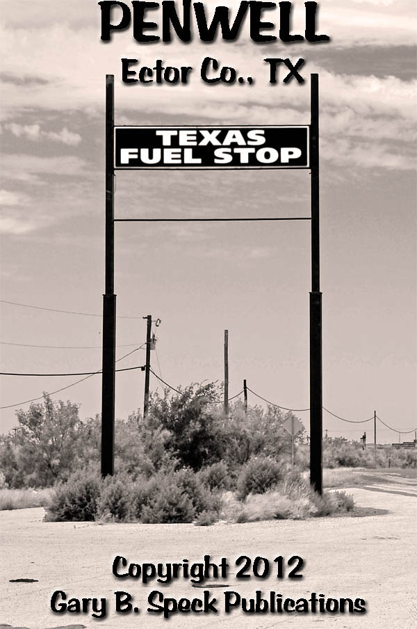
tall, yellow on black TEXAS FUEL STOP sign
drew me in like a chocoholic to the Hershey factory in Pennsylvania! (Yes I am,
and yes I’ve been there - twice.) I don’t know if the five island canopy was
related to the Country Kitchen complex with its two-island
gas canopy or not, but all were photogenic and turned
their empty faces and fading
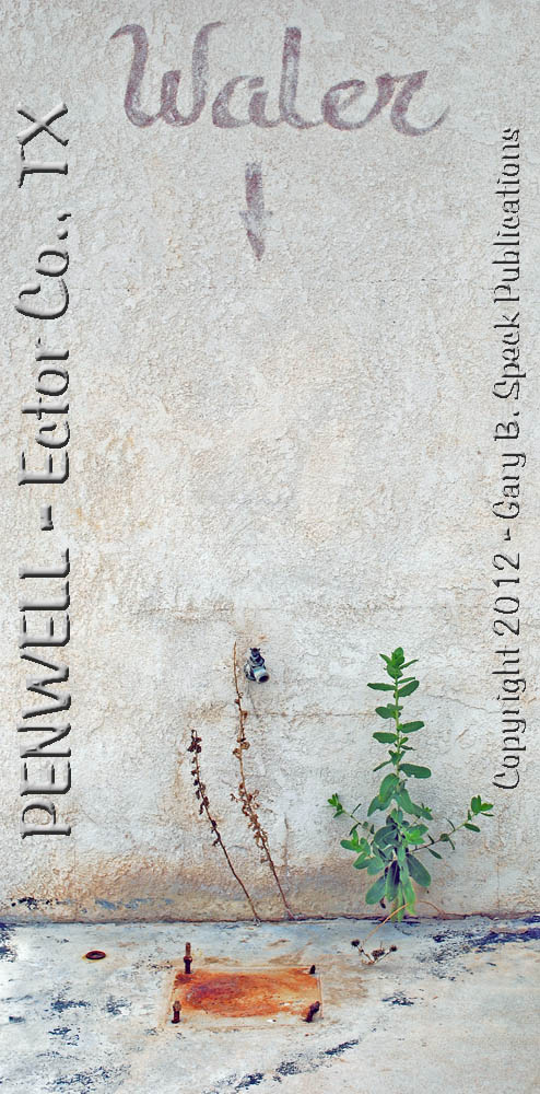
signs out towards passers-by. My favorite was the
innocuous little sign that simply stated, ”waler
.” Looks
like someone forgot to cross their “T”! An arrow pointed to a
long-dead spigot, and the rusting mounting bolts of a missing water/air
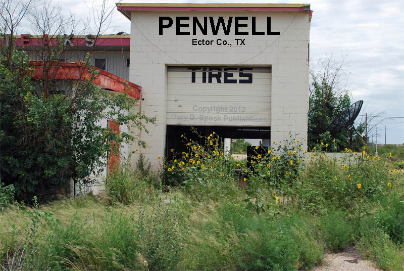
machine. Across the street to the east, across the junction with FM 1601 was another, smaller, former
gas station/repair garage with a sign announcing to the world that it was Penwell
Enterprises. Both complexes were of 1960s-1970s era vintage, the Country Kitchen
complex dating to 1962. But, what was even more interesting was the view under
the freeway overpass. There were a handful of
past-their-peak buildings and what looked like scores of oil tanks of various
sizes and colors in the town, all of which appeared abandoned.
This
was a promising start to a purely random stop.
Passing
under the freeway I felt like I died and went to ghost town
heaven. What appeared to be an active
welding shop anchored the northeast
corner of “Downtown,”
while scads of multi-hued, multi-shaped, multi-sized
oil tanks and numerous abandoned buildings lie scattered
amongst the dry, prickly
underbrush. Some of the indentifiable businesses
included: a sheet-metal
gas station, with the price of “full-service
diesel fuel” painted right on the side of the building. The
former gas
pumps sit forlornly, surrounded by prickly Texas greenery and the
odd rusty metal pieces. Next door is a concrete
block café (The
Joker Coffee Shop) and
just up the street, a stucco-sided, wooden automobile
repair garage. Other unmarked buildings lie scattered about
the townsite. At each street corner, white on stop sign-red street
signs stood proud, each marked with the name of the town. Along
the service road adjacent to the north side of the Interstate, old truck
scales with their faded, rusty
signage still wait for someone to stop and check their loads. All
this lay sandwiched between the Missouri Pacific Railroad tracks and the
present Interstate highway. Other than the constant thrumming of tires across
expansion strips and joints on the nearby Interstate, the silent streets
revealed little activity, no sound and lots of panache. This was not a typical
ghost, but a mid-century relic, killed off by big oil and the Superslab.
Penwell
only dates to October 7, 1929, when oilman/landowner Robert R. Penn drilled a
well that hit oil at 3700 feet. Penwell (Penn’s Well) and the Permian Basin Oil
Fields boomed and Penwell quickly sprawled along the Bankhead Highway (old US
80), which paralleled the railroad. It was platted November 08, 1929, and a
post office was established in June 1930. In 1930, the population had soared
from zero to either 230 or 3000 (depending on source), and Penwell was a
full-on oil boom town, mostly consisting of tents and flimsy shacks. Businesses
flocked here, including: a barber, boarding houses, three churches, a couple
clothing stores, dance hall, doctor’s office, drug store, gas stations, two
hotels, lumber yards, newspaper (The Penwell News), pool hall,
restaurants, saloons, a school and stores. In typical boomtown style, boom
turned to slow-and-steady, and as usually happens when the booms taper off, the
boomers disappeared, the town faded and businesses
folded. By 1980 the population had fallen to 75, and the
post office was still open, as were a gas station, liquor store and the welding
shop.
In
the 1990s Penwell was nearly abandoned with about 75 people. In 2000 it only
had seven occupied homes and an official (Census) population of 41. By 2010
even that number seemed high as only a couple of the homes appeared occupied,
and high
scrub was quickly filling in where buildings once stood,
or lie in wooden
heaps. According to the 2012 US Postal Service website
the Penwell Post Office (79776) is still in operation, but only
Monday-Saturday, 0800-1200. I sure didn’t see it on our visit, but….
What
the future holds is unknown, but in late 2012, the Texas Clean Energy Project is
scheduled to begin construction of a $350 million, 600-acre coal gasification,
400-megawatt electrical generation facility at Penwell. What this new plant will
do or how it will affect this wonderful little relic of the 1930s-1950s is
unknown. Until then, it is well worth a stop. Penwell
is located off I-20 at EXIT 101, 16 miles southwest of Odessa in the
southwestern part of the county. It is also the home of Texas’ only
quarter-mile long drag strip, the Caprock
Motorplex, which is located south of the freeway and town. It and a
neighboring 1/8 mile & later expanded to a ¼ mile oval dirt track have
operated off and on since September 1966.
As
always, when you visit, please abide by any posted
signage, respect the rights of the property owners and
always abide by the Ghost
Towner's Code of Ethics.
LOCATION:
·
Elevation
2936’
·
Latitude:
31.7398507 / 31° 44' 23" N
·
Longitude:
-102.5915352 / 102° 35' 30" W
***************
Visit
Ghost Town USA’s TEXAS Ghost Town Pages
* * *
Also
visit: Ghost Town USA’s
Home Page | Site Map | Ghost Town Listings | On The Road Again | Photo Gallery | Treasure Legends
CURRENT Ghost Town of the Month | PAST Ghost Towns of the Month
Ghost
Towner's Code of Ethics | Publications | Genealogy
| License
Plate Collecting
A
few LINKS to outside webpages:
Ghost
Towns | Treasure
Hunting | License
Plate Collecting | Genealogy
***

***
THIS
PAGE
FIRST
POSTED: November 03, 2012
LAST
UPDATED: December 06, 2012
**************
This
website and all information posted here-in is
copyright © 1998-2015
by Gary B Speck Publications
ALL rights reserved