RHYOLITE YESTERDAY & TODAY
Nevada's Ghost City
By
Gary Speck
Rhyolite AND Gary (the author of
this piece/website owner)
Were
featured on Life after people
Episode #4
Tuesday, May
12, 2009 on the History Channel!!!
No visit to
Permanence appears to have turned fleeting! Today, of the three, only Tonopah still
breathes comfortably. It is the Nye County Seat, and maintains a population of
about 2000 folks. Goldfield still hangs in there as the county seat of
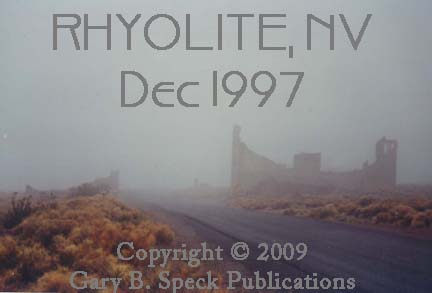
To set the mood for my first ghostly visit to this
wonderful old ghost in early December 1997, Nature and el
Nino presented us with a heavy fog and drizzle: a fog that socked in the entire
Rhyolite
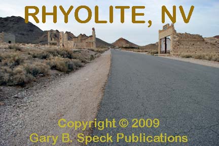
sits about four miles west of Beatty, and about 1.5 miles north of State
Highway 374. On the north side of the turnoff is the massive Bullfrog Gold
Mine, and to the south, across the highway, the remains of huge settling ponds
and tailing piles that were heap-leached before the mine closed in 1999. A
short distance up the road on the west is the Bullfrog-Rhyolite
cemetery, which we didn’t visit in 1997 due to lack of visibility and not being
able to find it! I did not visit it in
2009. About 3/4 mile up the road is a side road heading west past the ruins of
Bullfrog, only 1/4 mile west and now home to what in 2009, appears to be a
large, recently constructed building that I was told houses an artist colony.
Continuing up the hill, the road curves gently to
the right and in 1997 was home to a cluster of mobile homes and cabins fronted
with huge metal sculptures greeting the visitor. In 2009, those mobile homes
were gone and the cabins vacated, although a couple of the sculptures
remained as a welcome to town. Looking
north up the road toward the town itself is an eerie sensation either in the
fog or sunshine. The dark brooding hulks
of ruined buildings sit in a bowl at the base of mine-scarred hillsides. In 1997, the view was ethereal as the heavy
fog lifted just enough to bring the building ruins into focus. Before I could
stop and get a picture, the wet grey mist returned, again shrouding this
During my last visit in late February 2009, I was
part of an exciting experience. I was a participant in the filming of a
television series called Life After People, airing on the History
Channel. I was one of two people
featured that shared the history of Rhyolite and the
structural decay taking place in the buildings as time went on without human
intervention for repairs and maintenance.
I’m usually on the backside of a camera, sharing my experiences with the
readers of my Ghost Town USA
magazine column and this website. It was
truly a rewarding experience to be on the “pointy
end” of the camera sharing my zeal for ghost towns with a television
audience. Once I find out when the
episode will air I’ll share that here.
RHYOLITE YESTERDAY
Rhyolite
exploded onto the scene in August 1904 when well-known
As the discovery camp, Bullfrog had the advantage,
and became the focus of the rush that ensued. Soon however, the nearby site of Rhyolite, sprawled along a sloping alluvial plain between
Bonanza and Ladd mountains, attracted more boomers, and by the spring of 1905
the streets of Rhyolite were lined with canvas-sided
tents and wooden shanties, along with 1500 people.
Progress was rapid, and through 1906 tents and
shanties had been replaced by solid wood-frame structures and beautiful but
expensive cut rock and concrete buildings, some as tall as three stories. The rhyolite and granite rock was cut, dressed and transported
from local quarries.
In 1907 the town was at its zenith. Estimates of
population range from 3500 to 10,000 people, and most folks seem to think the
upper limit was in the 7-8000 range. No matter.
The booming city also claimed two railroads (the Las Vegas &
Tonopah, and the Tonopah & Tidewater), two daily newspapers, a magazine
(only one issue), two churches, auto stages, a stock exchange, doctors, dentists,
real estate offices, law offices, banks, eight grocery stores, 50 saloons,
restaurants, 19 hotels and boarding houses,
a flourishing red-light
district, opera house, a baseball team and a 14’ x 40’ public swimming
pool gave the community something few mining camps had. There were many other
businesses, all befitting a growing city.
(Time and additional research will probably modify some of those
numbers.)
In 1906, the
As Rhyolite faded,
people dispersed and the remaining buildings were abandoned.
RHYOLITE TODAY
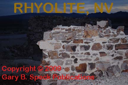
Over time, vandals and the weather have taken
their toll, and the gutted
structures began to crumble. Today the site is administered by the
Bureau of Land Management, and watched over by a citizen's group called
"The Friends of Rhyolite." They are raising
money to stabilize the buildings, and hopefully prevent further
deterioration. Unfortunately for us as
treasure hunters, metal detecting and collecting of any artifacts inside the
town limits is prohibited. There are BLM caretakers on site, and they insist
that visitors remain outside the perimeter of the buildings. Some are fenced others are not. Please do abide by their wishes. If you are in the area metal detecting at any
other ghost towns, a trip here is a must, just to see the place. It is
passenger car accessible.
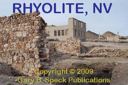
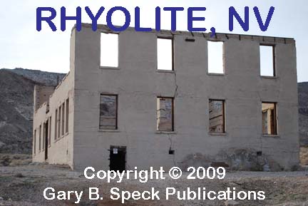
Some of the major buildings in town include:
The two-story
school had three classrooms on the lower level,
and an auditorium and a fourth classroom on the second. It was completed in
December 1908, and built for a total cost of $20,000. Bonds for the building were issued, and in
1978 were finally paid off. Today the
roofless and windowless walls remain, and a concrete
slab inside used to be claimed to help stabilize the structure, but in reality
was poured by a film company and has compromised the structural stability of
the school building.
The Overbury Building was a three-story cut rock and
concrete block building that cost about $60,000, when it was built in 1906 by
John T. Overbury. It housed a bank and general
offices and was completed in June 1907. On June 2, the 1st National Bank of Rhyolite held their grand opening on the first floor.
Across
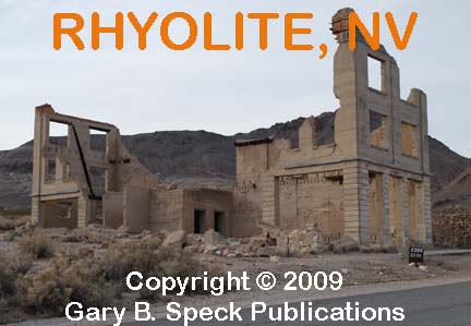
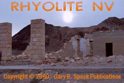
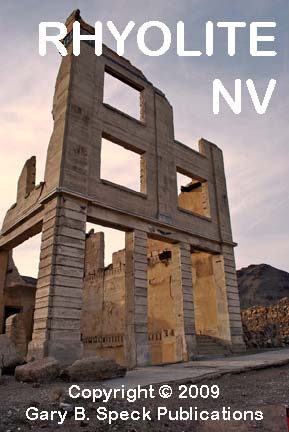
The picturesque, roofless John
S. Cook Bank building was one of four banks and the city's skyscraper
with a bank on the lower floor, and two floors of professional offices above.
Construction began in March 1907, and it was completed by the end of the year,
at a cost estimated to be between $60-90,000. The post office relocated into
the basement, and the doors were opened. They didn't remain open for long,
closing in the spring of 1910, forcing the post office to relocate. On December
31, 1910, the building's fixtures were sold at auction.
Adjoining the Cook building on the right was the
two-story
The Las Vegas & Tonopah Railroad erected a
beautiful railroad
depot that is still standing. After the railroad pulled out it was used
as a restaurant and casino, and later as a residence. At the time of our visit
in December 1997 it was unoccupied, but was fenced off by the Bureau of Land
Management (BLM) to prevent vandalism.
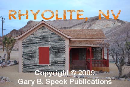
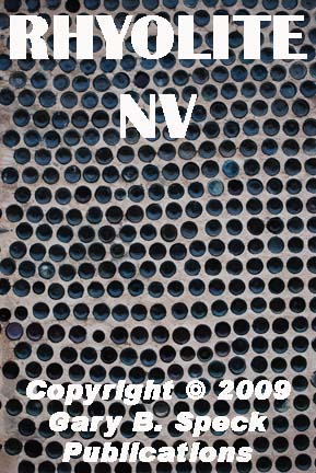
Other notable buildings in the town were the
four-celled concrete jail built in 1907, and the famous bottle
house. The later was built by resident Tom Kelly in 1906 with 20-30,000
beer,
whiskey and wine bottles and was lived in until 1989. It is the only
remaining one of three such structures. Like the railroad station, it has been
fenced off by BLM, and is eventually slated for restoration.
Standing on the crumbling sidewalk in front of the
John S. Cook Bank Building in the earmuff quiet of the cold, wet December fog,
it took very little imagination to hear the sounds of life passing by on the
streets of Rhyolite, Nevada's ghost city. A visit to this former city is a fantastic
trip into the past, but remaining after dark becomes
ethereal. After the sun goes
down and the daytime tourists leave, the quiet
streets of Rhyolite truly echo with the quiet
footsteps of its ghosts.
This was our GHOST TOWN OF THE MONTH for
November 1998, and this article
underwent a major modification and was re-featured as the Ghost
Town of the Month for April 2009.
This
is one of the towns featured in my newest
book, GHOST
TOWNS: Yesterday & TodayTM.
Location:
·
Latitude: 36.9038338 / 36° 54’ 14” N
·
Longitude: -116.8292274 / 116° 49’ 45” W
·
SE¼ Sec 9, NE¼ Sec 16, T12S, R46E, Mount Diablo Meridian & Base Line
***************
Visit Ghost Town USA’s NEVADA
Ghost Town Pages
Also visit: Ghost Town
Home
Page | Site Map | Ghost Town Listings
| On The Road Again | Photo Gallery
| Treasure
Legends
CURRENT Ghost Town of the
Month | PAST Ghost Towns
of the Month
Ghost Towner's
Code of Ethics | Publications | Genealogy
| License Plate
Collecting
A few LINKS to outside webpages:
Ghost
Towns | Treasure
Hunting | License
Plate Collecting | Genealogy
***

***
THIS
PAGE
FIRST
POSTED: December
01, 1998
LAST
UPDATED: January 11, 2014
**************
This
website and all information posted here-in is
copyright
© 1998-2015
by Gary B Speck Publications
ALL rights reserved