BROWNSON
Cheyenne County, Nebraska
by
HIDING IN PLAIN SIGHT out
in the western Nebraska
county of Cheyenne, are a handful of tiny towns, most on their last legs. Like other agriculturally-based towns in
America’s heartland, they are fading and disappearing at an increasing rate. One of these semi-survivors is BROWNSON, which is located just off US
30, a mile northeast of Interstate 80 at EXIT only seven miles northwest of
Sidney. We last visited here in 2005,
and at that time, we were staying in Sidney, and I wanted to visit some of
these old farm towns.
We arrived just as daylight was fading, so our
explorations were quick, and photography spotty as the fading prairie light
made a tripod necessary. I headed
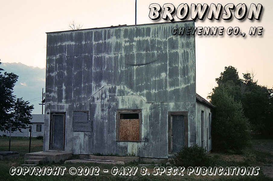
straight for a large brick building, which I spotted as we entered the town. Just past the turnoff from the main highway,
a TALL false-front caught my attention. In my 40+ years of exploring ghost
towns I’ve seen thousands of false-fronts.
But, this one took the prize as having the tallest
false front I’ve ever seen on a small single-story building. From the street it looks like a two-story
structure without windows on the upper floor.
It’s not! It’s only a
single-story, and my guess is the top of the false-front is over 20 feet above
the level grade out front.
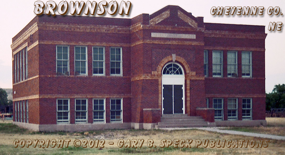
After a couple shots, we
headed towards that large
brick building we initially spotted.
It was now too dark to hand-hold my camera, so I set up the tripod for a
couple shots of what turned out to be an old school. Bats flitted about in the twilight chasing
bugs and a couple of unseen dogs announced the presence of a ghost town-chasing
stranger in town: a town that only had
20 folks in 2000. Because it is
unincorporated, I have not been able to find the 2010 Census figures. But, with the general trend heading south, I
feel it is probably less than 20 now.
This was not a town I had
pre-researched, so I was flying totally blind.
What I didn’t know at the time we visited, was the story of the town, or
of the bridge we’d just crossed coming into town. This 352’ long bridge was
built in 1942 to allow access to the Sioux Ordnance Plant, which was an old
military ammunition depot about two miles north of Brownson. It was active from 1942- June 30, 1967 and
according to the historical marker the SIOUX
ARMY DEPOT covered:
“…19,771 acres
and included 801 ammunition storage igloos, 22 general supply warehouses,
392 support buildings, 225
family living quarters, 51 miles of railroad tracks, and
203 miles of roads. Depot personnel assigned ranged from 625 to 2,161 civilian
employees and from 4 to 57 military personnel depending on Army activity.”
The
base also served as a Minuteman Missile site during the Cold War. In 1965, and operating after the base was deactivated, a portion
served as a campus for Western Nebraska Vocational Technical School, which
changed its name to Western Nebraska Technical College, in 1971. The school continued to operate until
1995.
The Sioux Army Depot
airfield is shown on a 1972 topographic map with multiple dozens of buildings
and railroad tracks looping back to large warehouse-like structures.
Brownson is located along the railroad,
seven miles west of Sidney and was once a busy little town. The post office was established March 02,
1887, and June 06, 1895 changed names from Bronson to Brownson. (Note the addition of the “W”) The 1890 State Gazetteer listed a general store,
justice of the peace and a postmaster.
It isn’t clear if the post office was located in the general store or
another building as the postmaster and storekeeper names are different. It was also a flag station on the rail line,
so it probably had some sort of platform or depot.
27 years later, according
to the 1917 State Gazetteer, Brownson still had its
post office, and was listed as a station on the railroad.
It finally got too dark to
explore, so I jumped back on I-80 and headed east towards Sidney, itself an
interesting, history-filled community.
It looks like I chose a good little town to explore, but I just wish I
would have had more time. Oh well!
As
always, when you visit, please abide by any posted signage, respect the rights of
the property owners and always abide by the Ghost Towner's
Code of Ethics.
This was our Ghost Town of the Month for December 2012
LOCATION - BROWNSON:
·
Elevation 4216’
·
Latitude: 41.1874828 / 41° 11' 15" N
·
Longitude: -103.1129824 / 103° 06' 47" W
·
NE¼ Sec 13, T14N, R51W, 6th Principal Meridian
LOCATION – SIOUX ARMY
DEPOT:
·
Elevation 4413’
·
Latitude: 41.2147046 / 41° 12' 53" N
·
Longitude: -103.1054826 / 103° 06' 20" W
·
NE¼ Sec 1, T14N, R51W / NW¼ Sec 6, T14N, R50W / Secs
8-36, T15N, R50W, 6th Principal Meridian
***************
Visit Ghost Town USA’s Nebraska Ghost Town Pages
* * *
Also visit: Ghost Town USA’s
Home
Page | Site Map | Ghost Town Listings
| On The Road Again | Photo Gallery
| Treasure
Legends
CURRENT Ghost Town of the
Month | PAST Ghost Towns
of the Month
Ghost Towner's
Code of Ethics | Publications | Genealogy
| License
Plate Collecting
A few LINKS to outside webpages:
Ghost
Towns | Treasure
Hunting
| License
Plate Collecting | Genealogy
***

***
THIS PAGE
FIRST POSTED: December 06,
2012
LAST UPDATED: January 12, 2013
**************
This
website and all information posted here-in is
copyright
© 1998-2015
by Gary B Speck Publications
ALL rights reserved