Ghost
Towns of the
SALTON SEA area
Imperial & Riverside Counties,
California
NOTE NUMEROUS CHANGES!
CALIFORNIA’S SALTON SEA is a very interesting location for ghost towners to explore.
Once I finish the book I’m under contract to write, I will complete this
guide to the Salton Sea
area ghost towns. Below is a
BRIEF outline of that work. FADED DREAMS-GHOST
TOWNS OF THE SALTON SEA should be available in early 2010. I journeyed to the Salton
Sea on Oct 24, 2009, to finish the photography and site
visits. Please note NUMEROUS changes
here. Due to extensive changes in some
of the places visited, I will probably make a couple more journeys to the Sea
in the next couple months to verify and photograph the other sites not visited
in October.
PLEASE HELP! I’m looking for additional HISTORICAL INFORMATION AND PERIOD PHOTOS for the Marinas,
Yacht Clubs and other sea-related
places that once operated along the shoreline of the Salton Sea, in Imperial
& Riverside Co., California
from 1958-1976 or so. I especially would
love to hear from folks that once frequented these places for fishing, boating
or general relaxation, and would like to share stories from “the good old
days”. Please let me know your
impressions of these places then, and if you’d like to share any photos.
I’m also looking for
information on Imperial
County Ghost Towns. I would like to publish a
guide to these locations concurrently with the Salton Sea Guide in 2010/early
2011 and still need a lot of information.
For additional details on the Salton Sea Ghost Town Guide, see Faded
Dreams.
PLEASE contact me if you ever visited any of
these places OR know of any that are not listed. Thank you!
* * *
AIR
PARK ESTATES (Imp)
In a 1961 article this
was one of the “planned communities in the making”. Location not determined, but it’s probably at
or near the Salton
City Airport.
AL & CHRIS’ RV PARK (Imp)
...SEE Corvina Estates
BENSON(S)
LANDING (Imp)
AKA - Westmorland Landing
1960s marina and landing
on the SW shore of the Salton Sea, north end of Poe Road, 2 mi N of SH 86 at a
point 9 miles NW of Westmorland, 6.9 miles SE of the jct
SH 78/86. With the sea level having
dropped several feet since 2007, the old site is walking accessible now. Remains include the tire-lined road, broken
dike walls, power poles and the rickety remains of the frame of a square
structure.
BERTRAM
(SIDING) (Imp)
Southern
Pacific RR siding 4 miles S of the county line, E side of the Salton Sea
between RR Mile Post (RRMP) 646.0 and 647.8.
BETZ BEACH (Riv)
MAY BE an
earlier name for Mecca Beach, or may be an earlier development that was superceded by Mecca
Beach.
BOB’S
PLAYA RIVIERA (Imp)
AKA - Playa Riviera
Just S of the county line, W
of SH 111 and about ¼ mile N of Corvina
Estates. Private
campground/boat launch.
BOMBAY BEACH
(Imp)
On
E shore of the Salton Sea. Partially flooded by the
sea. A dike separates it from the
sea. Est 1929, & by 1966, was a booming beach town. Flooded by a pair of tropical storms in mid 1970s. See a photo
of Bombay Beach here. Extensive changes since February 2007. In Oct
2009, the marina and crane are high and dry.
The old bakery truck is gone. The
famous trailer pictured nearly everywhere is a crumbled heap of debris. The old hardware store and other buildings on
the sea-side of the dike have been extensively vandalized and grafittied.
CALEB
(SIDING) (Riv)
Southern Pacific RR siding/loading
point W of Box Canyon, 3.8 miles SW of Mecca and 4.9 miles NW of Mortmar Siding (North Shore), N of the N tip of the Salton
Sea.
CHARLIE’S
PLACE (Riv)
Location not determined. North of the county line along the E shore of the sea. Near Durmid
Siding?
COOLIDGE
SPRINGS (Imp)
On Coolidge Springs Rd, NW corner of the
county, ½ mile W of SH 86, SW of Desert Shores, W of
the Salton Sea.
CORVINA BEACH (Riv)
AKA - Salton Beach
In 1939, Salton Beach
was a small resort on SH 111, 4 miles S of Date Palm Beach and 13.2 miles S of
Mecca. That would place it right at Salton Siding/Corvina
Beach. May be original name for today’s Corvina Beach, now an unimproved campground on E
shore of Salton Sea, 3 miles SE of North Shore.
CORVINA
ESTATES (Imp)
AKA - Al & Chris’ RV
Park
W
side of SH 111, 0.4 mile S of the county line. Abandoned café on highway
and RV park to W.
CORVINA MARINA (Imp)
...SEE Desert Shores
DAMASCUS (Riv)
Paper
town platted in 1894 a mile SE of Mecca. It never developed beyond the map.
DATE PALM BEACH (Riv)
...SEE Desert Beach
DE ANZA BAY MARINA (Imp)
...SEE Lido
Palms Marina
DEL MAR
ESTATES (Imp)
...SEE
Salton City. One of the
several named subdivisions in Salton
City.
DESERT
BEACH (Riv)
AKA - Date Palm Beach, Eiler’s Salton Sea Resort, North Shore
(GNIS)
A faded community on NE shore
of the Sea about ¼ mile S of North Shore marina, a mile N of Salton Sea State
Recreation Area entrance. Established in the early 1950s. The development is gated for residents
only. NO PUBLIC ACCESS.
DESERT
CAMP (Riv)
AKA - Palm Island
Estates
Mobile home
development, ¼ mile S of SH 111, 6.5 miles SE of Mecca, btw Arthur & Cleveland Streets, 2.2
miles W of the big curve NW of North Shore.
DESERT PALM BEACH (Riv)
Was located N of the Salton
Sea State Recreation Area headquarters.
A photo in The Salton Sea shows a marina & wharf with
buildings on it. It flooded with the
rising sea. Probably same as Date Palm Beach/Desert Beach
(above).
DESERT
SEA RANCHOS (Riv)
MH park site at the east end
of Parkside Drive, 1.7 miles east of the junction of Parkside Drive/SH 111 at
the Salton Sea State Recreation Area headquarters entrance south of Desert
Beach/North Shore, in the triangle formed by Parkside Drive, Powerline Road and Desert Aire
Drive.
DESERT
SHORES (Imp)
AKA - Corvina
Marina, Fish Springs
Faded
beach town from the late 1950s-early 1960s resort boom on W shore of the Salton
Sea. On E
side of SH 86, just 2 miles S of the county line.
DOS
PALMAS (Riv)
Site located about one
AIR mile SW of Dos Palmas Spring, about 5.5 AIR miles ESE of Desert Beach, 13
miles SE of Mecca. Stage station and
prospecting center, 1939 guest ranch, late 1940s a
popular Hollywood celebrity retreat known as Rancho
Dos Palmas. In 1989, the California
Nature Conservancy obtained the property, and has turned it into a nature
preserve.
DOS
PALMAS STATION (Riv)
AKA - Dos Palmos Post Office
Southern Pacific RR
station est 1877. Served as a construction camp, RR maintenance
& travel center for folks traveling the Bradshaw Road. Flooded in 1906, when Salton
Sea formed.
DOS PALMOS POST OFFICE (Riv)
...SEE
Dos Palmas Station
DRY
ICE WELLS (Imp)
East
shore of Salton Sea, 4 miles W of Niland, W of the jct of Davis/Noffsinger Roads.
DURMID
(SIDING) (Riv)
Southern
Pacific RR station and siding on the E shore of the Sea, just N of the county
line. Removed
c1960.
EILER’S
SALTON SEA RESORT (Riv)
...SEE Desert Beach
EL
RANCHO DEL
SOL (Riv)
This privately
campground/trailer park was located on the S side of SH 111, 0.3 miles E of
Desert Camp, about 1.8 miles W of North Shore. It has also been shown on maps
at two other locations.
FERRUM
(SIDING)/JUNCTION (Riv)
AKA - Salton Siding
(#2)
Railroad siding/junction est 1948 by Henry J. Kaiser at the
Southern Pacific RR siding of Salton (#2).
This was the junction of Eagle
Mountain
Railroad/Southern Pacific. On N side of SH 111 two miles N of the county line at MP 2.0. Rails, rubble & a large bin remain.
FIGTREE
JOHN SPRINGS
(Riv)
There
are two locations for this historic old spring on W side of Sea. The original site N of county line was flooded by sea in
1906-1907. Relocated to the former Agua
Dulce Spring, E of Oasis(?).
FISH
CAMP (#1) (Imp)
Underwater
about 4.5 miles NE of Elmore Desert Ranch.
FISH
CAMP (#2) (Imp)
1.1
mile W of Wister Station, northwest of Niland.
FISH
SPRINGS (Imp)
At
or near Desert Shores, W side of the Salton Sea. It appears the spring has been flooded out,
& was located at Desert
Shores.
FLOWING
WELLS (Riv)
Probably
along SH 111 about 3 miles SE of Mecca and 3 miles W of Desert Camp.
FRINK
(SIDING) (Imp)
AKA - Frinks
Southern Pacific RR siding on
NW side of the jct SH 111/ Niland
Marina Rd, 11.4 miles NW of Niland adjacent to the Border
Patrol Checkpoint.
FRINKS (Imp)
...SEE Frink Siding
HELEN’S BEACH HOUSE & HARBOR (Imp)
...SEE Salton Sea Beach
HELEN’S PLACE (Imp)
...SEE Salton Sea Beach
IMPERIAL
SALT COMPANY PLANT (Imp)
Former 1800s salt
processing plant 12 AIR miles NW of Niland, offshore
from end of Niland
Marina Road.
LIDO PALMS MARINA
(Imp)
AKA - De Anza
Bay Marina
Marina located at N end of Camino Drive, N of
Salton City.
LOPP’S TRAILER PARK (Imp)
...SEE The Corners
MARINE
VILLAS (Imp)
It was listed in a 1961
article a “planned communities in the making”.
The location is not determined.
MECCA
BEACH
(Riv)
Campground
1.5 miles SE of the Salton Sea State Recreation Area headquarters. Betz
Beach is on the N. In Oct 2009, it was closed.
MORTMAR
(SIDING) (Riv)
AKA - Mortmer,
Mortmere
Southern
Pacific RR siding and former station in the heart of North Shore, between the
hwy & res distr of North Shore Estates, on N side
of the Sea, nine miles SE of Mecca. Foundation of a section house, tamarisk
trees and
rubble remain.
MORTMER (Riv)
...SEE Mortmar
MORTMERE (Riv)
...SEE Mortmar
MULLET
ISLAND
(Imp)
In early 1950s was a
peninsula on SE shore of the Sea five AIR miles WSW of Niland
& N of the
mouth of the Alamo
River. Now a small island a mile
offshore. A
1920s and 1930s duck-hunting club and retreat.
NAVAL
AUXILIARY AIR STATION - SALTON SEA
(Imp)
AKA - Naval Air Facility -
Salton Sea, Salton Sea Base, Salton Sea Naval Base, Salton Sea Naval Test Base,
Salton Sea Test Base, US Salton Sea Base
Historic Navy Air Station
1942-1979. On a small
point, on SW shore of the Sea a mile N of where San Felipe Creek flows into it,
3.2 miles E of SH 86. CLOSED TO VISITORS.
NEVA’S STORE (Riv)
...SEE Skip’s
Store
NEW
LIVERPOOL SALT WORKS
(Riv) el
-
1884 salt works on dry
playa. A spur RR line ran out into the
dry lake bed W of Salton Station. Flooded in 1906. It
is underwater due S of North Shore and W of Corvina
Beach.
NILAND
MARINA (Imp)
1.9
miles west of The Corners. Abandoned marina/campground flooded by
Sea. Remains include several restroom
buildings & concrete rubble of former marina. With the sea level down a couple feet, the
marina entry walls are now exposed and accessible.
North
Shore (Riv)
AKA - North
Shore Estates, North Shore
Marina & Yacht Club
Faded
town on both sides of SH 111, on NW corner of the Sea about 9 miles SE of
Mecca. Remains include slab of
old motel, marina/yacht club and a closed market.
NOTE* Motel demolished in
2008, and the yacht club has been renovated and operates as a museum. See photos at link above.
(OASIS)
LANDING (Riv)
An UNNAMED boat
launching ramp was shown on several mid-1960s maps on the western Salton Sea
shore, east of Oasis and the junction of SH 86/81st Avenue. ANYONE
know anything about this one???
OLD SALTON CITY (Imp)
...SEE Salton City (1st
site)
PALM ISLAND
ESTATES (Riv)
...SEE Desert
Camp
PLAYA RIVIERA (Imp)
...SEE Bob’s Playa Riviera
POPE (SIDING) (Imp)
Southern
Pacific RR station and siding 1.8 miles W of Hot Mineral Spa Road and 1 mile NE
of Bombay Beach Road turnoff from SH 111, on E side of the Salton
Sea. No remains.
RANCHO DOS PALMAS (Riv)
1 AIR mile SW of Dos Palmas Spring & 5.5 AIR miles
ESE of Desert Beach. Part of Dos Palmas oasis (above).
RANCHO MARINA
(Imp)
Marina, launching ramp and private campground. Was ½ mile N of
Desert Shores on W shore of the Salton Sea.
RED HILL MARINA (Imp)
As
the sea level has dropped, the marina is no longer accessible to the water and
is not active (Oct 2009). The campground
on the north side of the former “near island” is still active with numerous
permanent looking campers.
SALT CREEK BEACH/CAMPGROUND (Riv)
Unimproved campground on E shore of Sea just S of Salt
Creek, 1.5 miles N of the county line.
SALTON
(#1) (Riv)
Flooded
Southern Pacific RR, station/siding for New Liverpool Salt Co. Company-owned
salt camp w/ housing and commercial support.
In 1906 flooded by the rapidly forming Salton Sea. The site is underwater.
SALTON (#2) (Riv)
...SEE Salton Siding (#2)
SALTON BEACH (Riv)
...SEE Corvina
Beach
SALTON CITY (Imp)
Quiet, faded beach town on W side of the Sea. Est 1959 and boomed through mid
1970s. Existing homes scattered across
the large townsite mix with many graded,
scrub-covered lots. Between February
2007 and Oct 2009, the former site of the old Holly House and its famous sign
has been redeveloped into a modern mini strip mall.
SALTON DEL MAR ESTATES (Imp)
...SEE
Salton City. One of the several named subdivisions in Salton City.
SALTON PARKSIDE (Imp)
Possible MH development on the W side of Range Rd, 1.5
miles N of its jct w/ SH 111, due E of Bertram
Siding.
SALTON PARKVIEW ESTATES (Imp)
Possibly a failed mobile home development on E side of
the road and ¾- mile SE of Salton Parkside (above).
SALTON SEA (town) (Imp)
On
1940s era maps on W side of US 99 (pre-SH 86), 2.4 miles due S of Salton Sea
Beach Rd jct & 3 miles N of Truckhaven. That puts it in area of the Salton Sea
Service Station, Salton Sea Oasis and Sea View Park.
SALTON
SEA BASE (Imp)
...SEE Naval Auxiliary Air Station - Salton
Sea.
SALTON SEA BASE B-2
¼
mile S of where Truckhaven Trail crosses Amerosa Wash, about 0.9 miles N of golf course, W of
Salton City.
SALTON SEA BEACH (Imp)
Faded
beach town from heyday in the 1958-1976 period. E of SH 86, 4 miles S of
the county line. Numerous old
trailers and homes on the north end of town that had been flooded and abandoned
have been removed or torn down.
SALTON
SEA NAVAL BASE (Imp)
...SEE Naval Auxiliary Air Station - Salton
Sea.
SALTON
SEA NAVAL TEST BASE (Imp)
...SEE Naval Auxiliary Air Station - Salton
Sea.
SALTON SEA OASIS (Imp)
E
side of SH 86, 1.3 miles N of Treadwell Ave., which is 3.7 miles N of Salton
City. This appears to have been an
ill-fated subdivision or trailer park in the area between Desert
Shores and Salton City.
SALTON SEA SERVICE STATION (Imp)
W
side of SH 86 on N side of Gravel
Wash, 6 miles S of the N county
line & 4 miles E of the W county line.
It is probably the same location as the modern Torrez-Martinez
Travel Center
on W side of SH 86, 1.6 miles S of the Salton Sea
Beach turnoff & 2.0 miles N of
Treadwell Ave (turnoff for N end of Salton
City).
SALTON
SEA TEST BASE (Imp)
...SEE Naval Auxiliary Air Station - Salton
Sea.
SALTON SEA TEST BASE B-1 (Imp)
WWII-
era military base E of the SE tip of Salton City,
NE of the airport, N of Surprise Wash.
SALTON (SIDING) (#1) (Riv)
...SEE Salton
SALTON (SIDING) (#2) (Riv)
...SEE Ferrum (Siding)/Junction
SALTON (SIDING)
(#3) (Riv)
Southern
Pacific RR siding 2 miles NW of Ferrum Jct., across
from Corvina Beach, 5 miles SE of North Shore at the
curve in the RR. Nothing remains.
SEA VIEW BEACH ESTATES (Imp)
Another
failed MH development on E side of SH 111, 1.5 miles WNW of Frink
Siding/The Corners, due N of Niland Marina. There is
no evidence of any development beyond grading and a crumbled road.
SEA VIEW PARK (Imp)
West
side of SH 86, 1.1 miles N of Treadwell Ave., which is 3.7 miles N of Salton
City. At or near 1996
map location of “Salton Sea.” Nothing visible, but some grading occurred in past.
SKIP’S STORE (Riv)
AKA –
Neva’s Store
This still active (Dec 2006) store on S side of SH 111,
0.2 miles W of jct of SH 111/Bay Drive, W of North
Shore.
SQUEAKY SPRINGS (STATION) (Imp)
AKA
- Winona
On
W side of SH 86 about 1.7 miles SE of Salton City, ½ -mile NW of Salton City
Airport Road. Nothing
visible.
SUNDIAL BEACH (Imp)
On W shore of the Sea, 3 miles S of the county line,
and S of Desert Shores. Name appears in a 1961
article as another of the “planned communities in the making.”
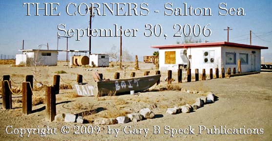
THE CORNER(S)
(Imp)
On
E side of Salton Sea, at SE corner of jct of SH 111/Niland Marina
Rd, 5 AIR miles E of Bombay Beach. The
site of this corner store/gas station, propane filling station, small RV camp (LOPP’S
TRAILER PARK) is located across from Border Patrol Checkpoint. The buildings still standing in February
2007 were gone October 24, 2009.
TRUCKHAVEN (Imp)
Old
service station/café on E side of US 99 (today’s SH 86), 1.3 miles NW of Salton
City. Remains include tamarisk trees,
concrete slabs & scattered debris.
U.S. SALTON SEA BASE
(Imp)
...SEE Naval Auxiliary Air Station - Salton
Sea.
WESTMORLAND LANDING (Imp)
...SEE
Benson Landing
WHITEWATER COVE (Riv)
A 1966
trailer park, store and boat launching ramp at the S end of Johnson St., on the N side of the Whitewater River where it empties into the north
end of the Sea. Flooded out.
WINONA (Imp)
...SEE Squeaky Springs
WISTER (SIDING/STATION) (Imp)
