Ghost Town
Guide to
the Ghost Towns, Mining Camps,
and Other
Formerly Inhabited Places in
Locations beginning with A
ACORN INN
This old inn was located at the junction of
SH 140/Triangle Road, about four AIR miles northeast of Mariposa. In 2002 it housed a church and revival
hall.
In 1854, D. C. CLARK built a sawmill
here. His old family home is still
standing across the highway from the old inn.
(Carolyn Feroben)
…SEE
also Clark’s
Sawmill.
…SEE Sawmills
for a listing of the various sawmills in
…SEE Way
Stations for a listing of the various way stations in
ADAMS & CARTER MILL
In 1885, a Mr. ADAMS and CARTER owned a ten-stamp mill at an undetermined
location.
ADELAIDE & ANDERSON
One of many mines located in the Coulterville
Mining District, which was located around the town of
AGUA
FRIA (CHL #518)
AKA – Agua Frio, Aqua Fria
smaller
than, and located about a mile northwest of Lower
AGUA FRIO
…SEE
Agua
Fria
AHWAHNEE HOTEL
Located in Yosemite
Valley east of Yosemite Village. When automobiles began to arrive in the
valley, the current hotel was built, opening its doors on July 14, 1925. It replaced an earlier complex that served
visitors arriving by pack train.
…SEE Way
Stations for a listing of the various way stations in
AKOZ MINE
This gold mine was located west of
ALABAMA
One
of many gold mines operating in the Sherlock-Whitlock area of the Whitlock
Mining District.
It was consolidated with the Whitlock Mine
into the Whitlock Group of Mines. Exact
location not determined.
ALTONS BAR
This early 1850s Merced River, placer gold-mining camp was located
just below the confluence of the South Fork of the Merced River with the main
branch of the
ANDERSON
Actual location not determined. Possibly on
ANITA MINE
In the Granite
Springs Mining District, which is located in the
upper northwest corner of the county, straddling the Tuolumne County line,
north of Lake McClure. Most of
the gold mines in the district closed down by the 1930s. Actual location of the mine is not
determined.
AQUA FRIA
…SEE
Agua
Fria
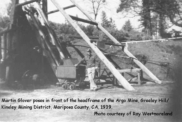
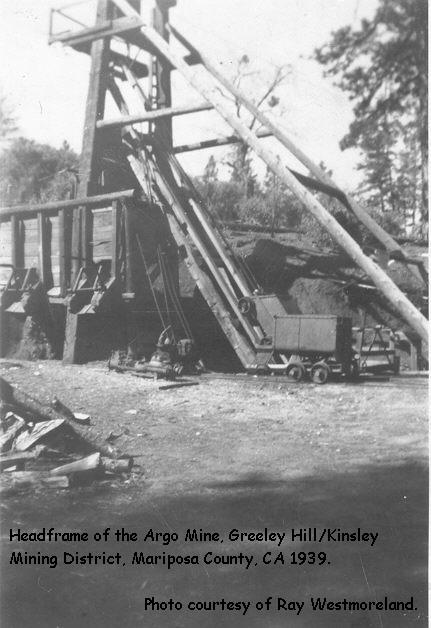
ARGO MINE
This gold mine was located between
Blackstone and
Photos:
(Photos courtesy of Ray Westmoreland.)
§ 1939
photo showing Martin
GLOVER in front of the headframe.
§ 1939
photo of headframe.
§ 1939
photo of a miner’s
cabin.
§ 2nd
photo of a miners cabin in
1939.
ARKANSAS
This was an early 1900s hard rock
gold-mining camp located along SH 140, about two miles west of Mariposa, and
0.5 mile east of
On April 10, 2002 we drove
past the area and I spotted some foundations on a flat area just south of SH
140. Could these have been the
remains? (GBS)
ARNOLD
Location
not determined.
ARTRU MINE
One of several mines operating in the Saxton
Creek area of the Whitlock
Mining District. It was located
somewhere along the
AUSTRALIAN GULCH
This old gold mining camp and granite
quarry was located two miles south of the junction of SH 49/Ben Hur Road, just east of Mormon Bar. In 1858, the
AVE MARIA
This early 1850s gold-mining camp was
located about a mile south of Mariposa at the confluence of Mariposa and Stockton
creeks, near the Mariposa County Fairgrounds and Mormon Bar. It was owned and operated by the Ave
Maria Mining Company.
* * *
Return to the GTs of
Mariposa Co., CA Index Page
Mariposa County
A | B | C | D | E | F | G | H | I | J | K | L | M | N | O | PQ | R | S |TUV
| W | XYZ
Detailed information on individual
locations:
AGUA
FRIA | BAGBY | BEAR
VALLEY | COULTERVILLE
| HORNITOS | MARIPOSA
| MOUNT
BULLION
Also visit:
Ghost Town USA’s Ghost Towns of
California
Also visit: Ghost Town
Home
Page | Site Map | Ghost Town Listings
| On
the Road Again | Photo Gallery
| Treasure
Legends
CURRENT Ghost Town of the
Month | PAST Ghost Towns
of the Month
Ghost Towner's
Code of Ethics | Publications | Genealogy
| License Plate
Collecting
A few LINKS to outside webpages:
Ghost
Towns | Treasure
Hunting | License
Plate Collecting | Genealogy
First
Posted: December 10, 2001
Last
Updated: March 19, 2005

This
website and all information posted here-in is
copyright
© 1998-2015
by Gary B Speck Publications
ALL rights reserved