TWO GUNS
Coconino Co., AZ
by
TWO GUNS, Arizona is the ruins of a unique old road town/trading post that once sat alongside US Highway 66, better
known as Route 66. From the 1930s to the
early 1970s when the interstate system much eliminated most of the old
highways, these squiggly blue map-lines piercing America’s Outback sported
motels, gas stations, highway diners and other tourist-attracting amenities
marking map dots all trying to pass themselves off as towns.
The old route of US 66 across
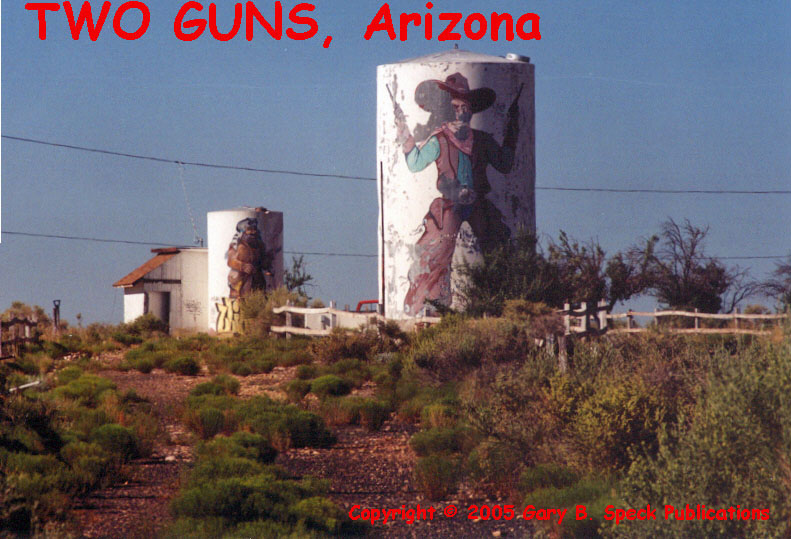
East of Flagstaff, at Exit 230, an abandoned, late-20th
Century gas station and an abandoned recreational vehicle overnighter campground
mark the site of Two Guns, a one-time busy
Just west of the gas station and campground, rock ruins indicate
an earlier permutation of the town. A
service road runs parallel to the freeway, looping past the foundations and gas
pump-island of an old service station.
Adjacent to it is the huge stone foundation of what may have been a
store, and a small block electrical building with the name Two Guns painted on
it. Just to the south, along the north
rim of the canyon was a rock ruin with “Mountain Lions” painted on the rock
fascia. Walking through the building
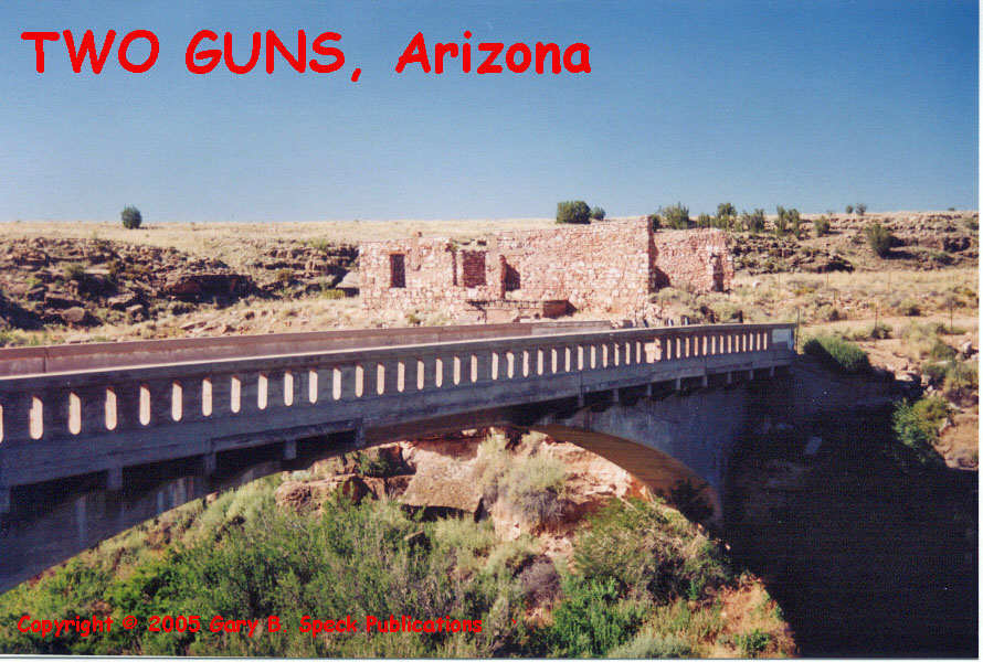
that once housed a small zoo, the overlook to the canyon caught my eye. Across that canyon, rock ruins blended into
the native rocks. A bridge
crosses the canyon, past the ruins of a large store, in front of which Route 66
once carried countless thousands of tourists over this bridge and through the
town.
The overall site consists of several clusters of buildings on
both sides of a hairpin curve of Canyon Diablo.
The southernmost cluster of ruins appears to have been a gas station set
in front of a circular drive backed by a long rock building that looked to me
like an old motel or tourist court. Some sources claim the now roofless
structure was an “Indian
Pueblo” created for 1930s era tourists.
A round rock “hogan” and four-holer outhouse rounded out the identifiable
structures. Other ruins and foundations
were unidentifiable.
A quarter-mile east of that cluster on the east side of the
canyon opposite the bridge, three other rock ruins were visible. I believe they marked the site of the
once-famous “Apache” caves, a spot that once drew money magically from the
pockets of tourists.
The ruins of Two Guns consist of 15-20 structures and a highway
bridge. It looks like when the
Interstate came through and traffic was rerouted away from the old location,
the “town” drifted closer to the freeway off ramp, hence the “modern” gas station,
garage and tourist camp. It appears that
sometime in the past decade they closed.
Today, the quiet ruins
of Two Guns invite exploration. When you
do visit, please abide by the Ghost Towner’s Code of Ethics. Two Guns is one of the few ghost towns that
is adjacent to a major interstate and served by its own on and off ramp.
·
S½ Sec 14, T20N, R12E, Gila & Salt
River Meridian
RUINS:
·
Latitude: 35.1164025 / 35° 06' 59" N
·
Longitude: -111.0962543 / 111° 05' 47" W
“NEW” TWO GUNS (center of
gas station building):
·
Latitude: 35.1146825 / 35° 06' 53" N
·
Longitude: -111.0907406 / 111° 05' 27" W
WEST BOUND I-40 OFFRAMP:
·
Latitude: 35.1169138 / 35° 07' 01" N
·
Longitude: -111.0856202 / 111° 05' 08" W
EAST BOUND I-40 OFFRAMP:
·
Latitude: 35.1178002 / 35° 07' 04" N
·
Longitude: -111.0953003 / 111° 05' 43" W
This was our Ghost Town of the Month for December 2005.
***************
Visit Ghost Town USA’s ARIZONA
Ghost Town Pages
Also visit: Ghost Town
Home
Page | Site Map | Ghost Town Listings
| On The Road Again | Photo Gallery
| Treasure
Legends
CURRENT Ghost Town of the
Month | PAST Ghost Towns
of the Month
Ghost Towner's
Code of Ethics | Publications | Genealogy
| License Plate
Collecting
A few LINKS to outside webpages:
Ghost
Towns | Treasure
Hunting | License
Plate Collecting | Genealogy
***

***
THIS PAGE
FIRST POSTED: December 07, 2005
LAST UPDATED: September 15, 2013
This
website and all information posted here-in is
copyright
© 1998-2015
by
Gary B Speck Publications
ALL RIGHTS RESERVED