GOLDROAD, Arizona
by
A pair of crumbling blacktop lanes
drift and dip with the scenery flowing southwest from the neon ribbon-strip
called
A mile west (between MP 32 & 33) is Ed’s Camp, which in 1997
was a motley collection of occupied shacks and mobile homes. It looks about the same now. Even though this historic old site is vacant,
it is NOT abandoned. Please note the
difference, and respect the rights of the property owner. If you do stop here, please observe all
buildings from the road shoulder OUTSIDE
the property.
At MP 30 a couple of foundations and excavations are visible just
east of 3523'
The gold mines at Goldroad were
discovered by Jose Jerez, around 1899 or 1900, and as the story goes, he was
working off a grubstake from Henry Lovin. He was camping at the site, when he
discovered rich gold-bearing ore. One
story claims Lovin was the Mohave County sheriff, but
Nell Murbarger and other sources say Lovin was a Kingman storekeeper. That seems more realistic as later when Goldroad was enjoying its glory days in the sun, there was
a Lovin Saloon.
In any case, the mine was discovered, then Lovin and Jerez sold it in 1901 for $50,000. In 1902, new owners incorporated the mine for
$1.5 million.
One of the most persistent stories of the discovery has Jerez
breaking off a heavy chunk of rock from a ledge to chuck at his burro. It’s not
noted why, but this story has been told of nearly every major discovery
throughout the west. Anyway, he noted
the weight of the rock, which turned out to be rich gold ore. Jerez is credited with the discovery, and in
true prospector fashion is said to have drank away his portion of the proceeds
from the sale of the mine...in the Goldroad saloon
owned by Lovin, who purchased it with his share of
the proceeds from the mine sale. I can’t
vouch for the truth of the tale, but it sounds plausible.
As the mine pumped out the gold, the little town grew. A post office opened in 1906, but a year
later, the rich gold veins pinched out after the mine had produced $2.25
million. Even though the mine closed for
a few years, the town struggled along.
Then in 1911 the Goldroad Mine reopened under
new ownership, and the town enjoyed another brief bout of prosperity. Period photos show scores of buildings,
including Lovin’s Goldroad Club
and a two-story structure that looks like a boarding house or hotel. During this boom cycle, the population is
said to have been around 400 people. The mine closed again in 1931, after
producing $7.3 million.
In 1940, the WPA Guide to Arizona called Goldroad
“a typical small mining community,” and listed the population at
52. However, what finally killed the
town was World War II and the 1942 government ordered closing of most of
America’s mines for the “war effort.”
That was the nail in the coffin. Goldroad rolled over and kicked off its boots. In 1949, the remaining wood-frame buildings
were demolished, while the rock and adobe ones were rendered unusable so the
owner wouldn’t have to continue paying property taxes on unoccupied buildings.
In 1951, at the time of Murbarger’s
visit, Goldroad still had a “...combination
grocery, gasoline station, bar, and blacksmith shop. Our visit happened to fall
on one of the days when the place was closed, and though we spent more than two
hours in the old town we didn’t see even one person... Most of the adobe and rock buildings had been
de-roofed and their empty shells stood hollow and ghostly.”
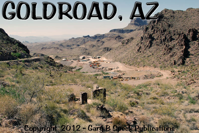
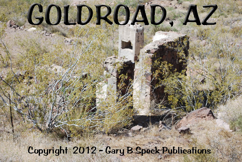
Sixty years later, not much has changed. Except for the active gold
mine. Today, those same adobe and rock
buildings that had been de-roofed, their empty shells standing hollow and
ghostly, still are. It is worth a brief
pause on the journey to or from OATMAN. The best viewpoint is from the upper (east)
end of town, looking west over the town site and active gold mine.
GOLDROAD:
·
SW¼ Sec 11, T19N, R20W,
Gila & Salt River Meridian
·
Latitude: 35.0466689 / 35° 03' 48" N
·
Longitude: -114.3796810 / 114° 22' 47" W
ED’S CAMP:
·
NW¼ Sec 17, T19N, R19W,
Gila & Salt River Meridian
·
Latitude: 35.0338916 / 35° 02' 02" N
·
Longitude: -114.3266238 / 114° 19' 36" W
COOL SPRINGS:
·
SW¼ Sec 16, T19N, R19W,
Gila & Salt River Meridian
·
Latitude: 35.0273937 / 35° 01' 39" N
·
Longitude: -114.3088013 / 114° 18' 32" W
This (coupled with OATMAN)
was our GHOST TOWN OF THE MONTH for March 1999.
Goldroad is one of the towns
featured in my newest book, GHOST
TOWNS: Yesterday & TodayTM.
***************
Visit Ghost Town USA’s ARIZONA
Ghost Town Pages
Also visit: Ghost Town
Home
Page | Site Map | Ghost Town Listings
| On The Road Again | Photo Gallery
| Treasure
Legends
CURRENT Ghost Town of the
Month | PAST Ghost Towns
of the Month
Ghost Towner's
Code of Ethics | Publications | Genealogy
| License Plate
Collecting
A few LINKS to outside webpages:
Ghost
Towns | Treasure
Hunting | License
Plate Collecting | Genealogy
***

***
THIS
PAGE
FIRST
POSTED: March
01, 1999
LAST
UPDATED: September 15, 2013
**************
This
website and all information posted here-in is
copyright
© 1998-2015
by Gary B Speck Publications
ALL rights reserved