ON THE ROAD AGAIN
With Ghost Town
A Tour Guide
to the Ghost Towns Along
“OLD” U.S. HIGHWAY 80
From Yuma to Gila Bend, Arizona
PART 2
Mohawk-Gila Bend
Continued from: PART 1: Yuma-Mohawk
Mohawk lies midway on the
188-mile run between Yuma and Gila Bend, Arizona. Here, deep in the heart of Yuma County, a
string of dead and near-dead mapdots are parked at
near six-mile increments along Interstate 8, old US Highway 80 and the Southern
Pacific Railroad. Heading east from
mohawk,
we take aim at the next location (SEE the west half of this route at: Yuma-Mohawk.)
STOVAL
The barren site of
this former railroad stop sits along the railroad, running south of I-8, seven
miles northeast of Mohawk
and six miles west of Dateland. As Stoval is a barren site, I
didn’t attempt a visit. Today it is nothing more than a 1.7 mile-long
siding stretching between milepost (MP) 61 about a quarter mile shy of MP 63.
The early history
of this former community is about as confusing as that of Mohawk and the still
to be visited Dateland. As these sites are all interrelated and shifted
location and names, it depends on the source. During the steam engine era, water
stops, stations and sidings were established every half-dozen miles or so. Often wells ran dry, or other
development occurred and these sites would shift. The railroad company and site developers
were also notorious for changing names or reinventing past names. In this land of wandering railroad
stations, post offices followed suit.
They moved about to accommodate a rootless population.
Stoval began as a
Southern Pacific Railroad station some 70 miles east of Yuma and about seven
miles southwest of the Butterfield Overland Stage
Company station called TEXAS HILL,
which was located up on the Gila River.
When the railroad station was established in 1880, it began as Texas
Hill and around 1882, a farming colony called CHRISTVALE was established by Oscar F.
Thornton. When the post office was
established on September 25, 1888, Thornton was assigned as the first
postmaster, but the Post Office Department changed the name to CHRYSTOVAL, or CRYSTOVAL (without the “H”). In order to save money on
telegraphing, the railroads asked that the name be shortened, and in 1911, it
became STOVAL.
BUT, the naming
confusion doesn’t end there.
Various maps published in the mid 20th Century also spell it
differently. It is shown as STOVA on my 1938 Rand McNally road atlas, while on Chevron
Oil Company’s 1963 & 1970 maps it is shown as STOVALL (2-“L”s). The
United States Geological Survey’s online Geographic Names Information
System (GNIS) lists it as STOVAL,
with Christvale, Chrystoval,
Crystoval, Grinnell Station, Stanwix
and Texas Hill all as variant names.
In any case, today, you can call it gone!
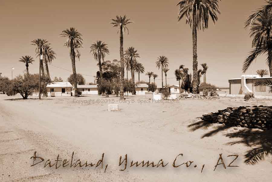
DATELAND
At EXIT
67, some six miles beyond Stoval is DATELAND.
Today,
this once-booming agricultural community, tourist and railroad water stop is
hanging onto life – barely.
Most of the town is located south of I-8 and was originally established
in the early 1920s as Musina. On September 22, 1928, the Le Sage Post Office opened its
doors with Sylvester H. Jansen the first postmaster. That name proved
highly unpopular and the residents petitioned to have it changed.
The highway was paved by 1931, and
traffic began to stop at newly established tourist amenities. A resurgence
began, and date palms were planted in the area. Dateland
Farms established a large, combination gas station/café/gift store along
the highway, and the community, which also included a motel and post office began
to be known as Dateland.
In the early 1960s, Interstate 8 was built, and even
though the town received an offramp, it
languished. Ownership changed
regularly until early 1995 when a Canadian couple bought the town and began
renovations. They added new
businesses along the freeway which successfully lured traffic off the
interstate.
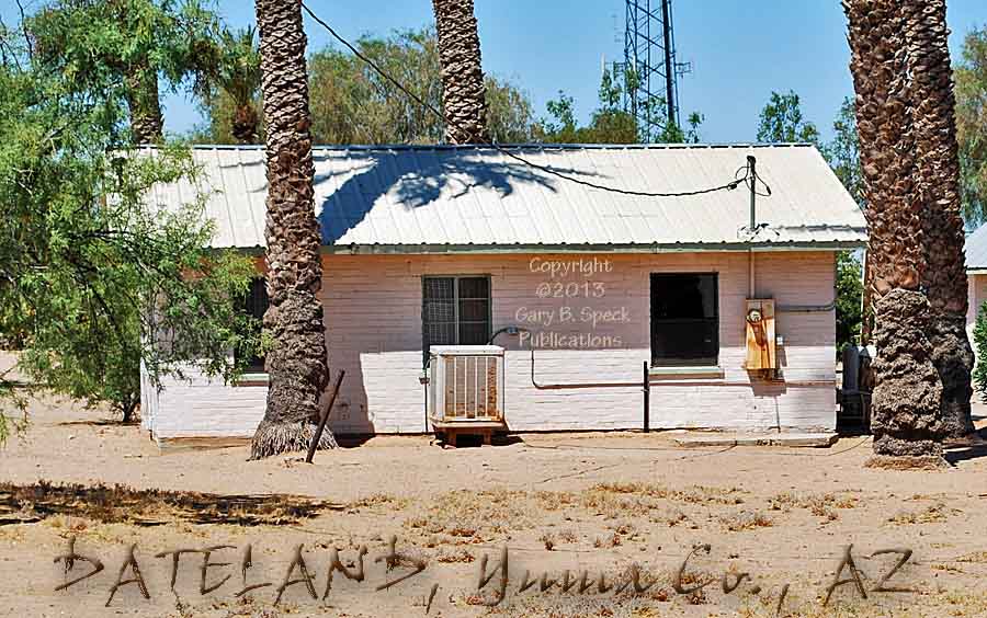
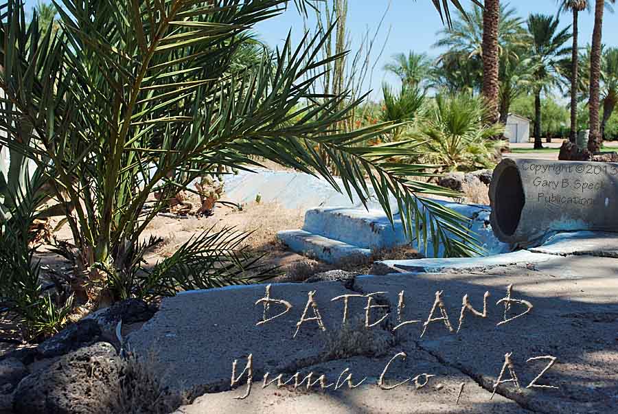
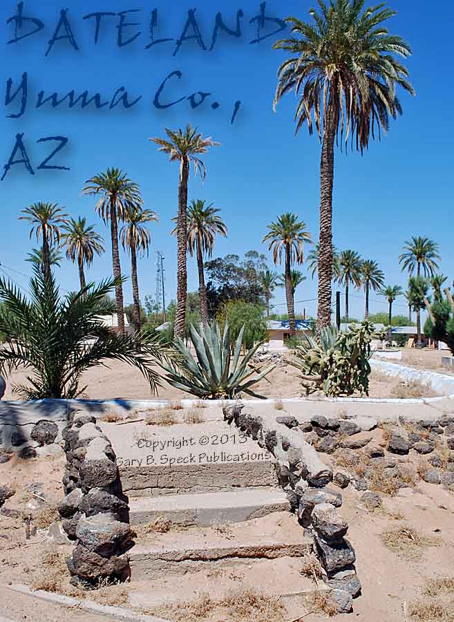
The original Dateland
Farms buildings are gone, having been demolished in 1997. West of its site, a few small
cabins, the semi
filled-in irrigation pond/swimming
pool and date palm groves all remain along the old highway south of
present-day Dateland.
North of the freeway, a modern school has been built, just west of the
southwestern corner of …
DATELAND
ARMY AIRFIELD
The DATELAND (DATELAN) ARMY AIRFIELD is one
of many training fields built during the Second World War to enable training of
troops heading overseas for battle.
It opened June 1, 1943 and was garrisoned on July 8, serving as a
training center for gunnery crews.
It was also an auxiliary airfield for the Yuma Aerial Flying School
Gunnery Range. However by September, it had been converted to a B-25 training
center and some 40-50 of the bombers had transferred there from Mather Field,
located a dozen miles northeast of Sacramento, California. They trained for a few months and moved
on.
It air field
consisted of two main runways connected by a taxiway. A nearby concrete apron had a 122’
x 80’ wooden hanger building.
That hanger and several other buildings along the flight line burned in
1957, the same year the air base closed.
The main portion of
the base was located south of the runways, the site having been bisected by
I-8. At the time of my visit, the
best foundations and slabs lie south of the freeway and east of Ave 64E. These remain of the 95 support buildings
for the former air field. Some
sources also claim there was a Prisoner of War Camp holding Italian prisoners
here.
Unlike other old
bases, this one has not been converted to public use, and is signed against
trespass.
AZTEC
Jumping back onto I-8 we continued east to the
site of AZTEC. What first caught my eye here at EXIT 73 and was the tall, rusty-steel,
railroad water tower sitting between the railroad and the Interstate on the
south side of the freeway. These
old towers are getting quite rare and seeing one in this condition was a
pleasant surprise.
North
of the freeway additional remains of this once-busy little US 80 road-town
include foundations, a topless freeway sign post and a two-legged canopy from a
gas station and restaurant complex. On the slab of the former café,
faded floor tiles curl and crumble in the merciless sun, while paint slowly
fades and peels off the canopy as memories of busy days slip further into the
past.
Off to
the west a bit is a well-aged corrugated metal building, its once red metallic
sheets flapping and rattling in the ever-present breeze. Both of the west
corners have been damaged, and the old shed wasn’t too far from becoming
just another faceless pile of rubble.
Between it and the freeway, frondless, dead palm trees sprawl on the ground,
looking like amputated elephant trunks.
An abandoned, skeletal, steel pipe, roadside trinket stand stands guard
over piles of long-dead tires.
Barely mounted above, the sun-blasted remnant of a plywood sign tries to
sell “Indian Head… Arrow….” Just to the west of that
are the remains of what appears to have been a mini-RV park with seven
brick-lined concrete slabs arranged in a quarter-circle pattern. Further west is the ready-to-fall
skeleton of a former house.
Additional piles of debris announce former building locations.
An
active feedlot at the south end of AZTEC
is the only thing that isn’t dead.
AZTEC dates to 1881, when the Southern Pacific Railroad
established a station and watering stop here. A town slowly developed, and the
post office was established September 12, 1889 with Charles A. Dallen as the first postmaster. In the 1930s it had become a bustling
railroad stop and trading point for ranchers and tourists. The population probably peaked in 1930
with 31 folks, but by 1980, that had faded to 15, and none today.
STANWIX
We now cross into
Maricopa County and pass the barren site of STANWIX. Again, much
like a number of the other sites we’ve visited in this stretch, the name
began as a Butterfield stage station, the reinventing itself along the
railroad. STANWIX stage station was also known as THE DUTCHMANS and FLAPJACK
RANCH and was located about nine miles northwest of where I-8 crosses the
county line. The stage station was occupied briefly by Confederate troops in April 1862, and in 1877 was
an office on the military telegraph line.
Around 1900, the Southern Pacific Railroad
adopted the name for a new station and siding about 12 miles east of
Aztec. Even though the site is
barren, the name lives on in a rest area, appropriately named – STANWIX!
SENTINEL
About 6.5 miles east of Stanwix,
and located on S. Agua Caliente Road, just north of I-8 at Exit 87 is SENTINEL. The Southern Pacific Railroad named it for nearby Sentinel Peak when they
established the station in 1880.
The post office opened June 30, 1880 with William C. Burke as the first
postmaster. Today, several
buildings remain: a small store is
still open, but its gas station is dry; the gutted shell of another gas station
sits to the west; a closed restaurant and several other unidentified buildings
round out the site. In the 1930s,
78 folks lived here, and the WPA Guide to Arizona called it a “trading
post in a 400 square mile lava bed area.”
Continuing east
from SENTINEL, are the barren sites
of TARTRON, MIDWAY STATION and PIEDRA, as well as the half-abandoned
agricultural community of…
THEBA
This
Southern Pacific Railroad siding is located south of I-8 and just west of Exit
106, ten miles west of Gila Bend.
It has a unique air about it as there are quite a few modern-looking
buildings, including small apartments, most of which appear empty. This is an agricultural area and
probably serves as a housing area for the workers. On the eastern part of “town”
are what appear to be vacant mobile home slabs. In 2000, the Census counted 150 folks,
but that had declined to 100 in 2009.
It is definitely a town on the shady side of its prosperity.
SMURR
The
last stop before hitting Gila Bend is four miles east of Theba
and six miles west of Gila Bend. The vacant site of SMURR is a mile west of Exit 111 on the frontage road running along
the south side of the freeway.
This ends our journey along the remaining segments of
US 80 between Yuma and Gila Bend, Arizona.
Someday soon, I’ll again hear the siren call of this road, and
continue this journey to the east.
Until that happens, there are other roads to explore and thousands of
other ghost towns to photograph!
Keep the greasy side down and the shiny side
up. Happy journeys and we’ll
see you On
the Road Again!
This
was our Ghost Town of the Month for October 2013.
PART 1: Yuma-Mohawk
PART 2: Mohawk to Gila Bend
Click here to see more ghost towns in Arizona.
GPS
and Standard Township/Range locations for the sites featured above.
|
SITE NAME |
ELEV. |
LATITUDE |
LONGITUDE |
TOWNSHIP/RANGE |
|
Aztec (Yuma
Co.) |
495’ |
32.8244925 / 32°
49’ 28” N |
-113.4499130 / 113°
27’ 00” W |
NW¼ Sec 13, T7S, R11W, GSRM
(Gila & Salt River Meridian & Base Line) |
|
Dateland (Yuma Co.) |
446’ |
32.7964368 / 32°
47’ 47” N |
-113.5410275 / 113°
32’ 28” W |
SE Corner Sec 24, NE corner Sec 25, T7S, R13W,
GSRM SW corner Sec 19, NW corner Sec 30, T7S, R12W,
GSRM |
|
Datelan(d) Army Airfield (Yuma Co.) |
446’ |
32.8133810 / 32° 48’ 48” N |
-113.5218602 / 113° 31’ 19” W |
Secs
17, 18, 19, 20, T7S, R12W, GSRM |
|
Midway Station (Maricopa Co.) |
823’ |
32.8906045 / 32°
53’ 26” N |
-113.0596202 / 113°
03’ 35” W |
E-Ctr Sec 22, T6S, R8W,
GSRM |
|
Piedra (Maricopa Co.) |
725’ |
32.9047709 / 32°
54’ 17” N |
-112.9854509 / 112°
59’ 08” W |
W-Ctr Sec 16, T6S, R7W,
GSRM |
|
Sentinel (Maricopa
Co.) |
690’ |
32.8581047 / 32°
51’ 29” N |
-113.2132371 / 113°
12’ 48” W |
SE¼ Sec 31,
SW¼ Sec 32, T6S, R9W, G&SRM |
|
Smurr (Maricopa Co.) |
732’ |
32.9286580 / 32°
55’ 43” N |
-112.8212787 / 112°
49’ 17” W |
SE¼ Sec 1, T6S, R6W, GSRM |
|
Stanwix (railroad station) (Maricopa Co.) |
548’ |
32.8397710 / 32°
50’ 23” N |
-113.3229636 / 113°
19’ 23” W |
Line between Sec 6 & 7, T7S, R10W, GSRM |
|
Stoval (Yuma Co.) |
400’ |
W end: 32.7617145 / 32° 45’
42” N E end: 32.7650478 / 32° 45’
54” N |
W end: -113.6310308 / 113° 37’
52” W E end: -113.6111416 / 113° 37’
20” W |
W
end: NE¼ Sec 5, T8S, R13W, GSRM E
end: NW¼ Sec 4, T8S, R13W, GSRM |
|
Tartron (Maricopa Co.) |
728’ |
32.8789379 / 32°
52’ 44” N |
-113.0998994 / 113°
06’ 00” W |
NE¼ Sec 29, T6S, R8W, GSRM |
|
Theba (Maricopa Co.) |
728’ |
32.9194921 / 32°
55’ 10” N |
-112.8946145 / 112°
53’ 41” W |
SE¼ Sec 8, T6S, R6W, GSRM |
|
Historians estimate that
there may be as many as 50,000 ghost towns scattered across the The Ghost Town
Guru's Guide
to the Ghost Towns of “STATE”™ These original guides
are designed for anybody interested in ghost towns. Whether you are a casual
tourist looking for a new and different place to visit, or a hard-core ghost
town researcher, these guides will be just right for you. With over 30 years
of research behind them, they will be a welcome addition to any ghost towner's library.
Thank you, and we'll see you out on the
Ghost Town Trail! For more information on
the ghost towns along this portion of E-mailers,
PLEASE NOTE: Due
to the tremendous amount of viruses, worms and “spam,” out there,
I no longer open or respond to e-mails with unsolicited attachments, OR
messages on the subject lines with “Hey”, “Hi”,
“Need help”, “Help Please”, “???”,
or blank subject lines, etc. If
you do send E-mail asking for information, or sharing information, PLEASE indicate the
appropriate location AND state name, or other topic on the
“subject” line. THANK
YOU! :o) |
IMPORTANT These listings and
historical vignettes of ghost towns, near-ghost towns and other historical
sites along this portion of US HIGHWAY 6 above are for informational
purposes only, and should NOT be construed to grant permission to trespass,
metal detect, relic or treasure hunt at any of the listed sites. If the reader of this
guide is a metal detector user and plans to use this guide to locate sites
for metal detecting or relic hunting, it is the READER'S responsibility to
obtain written permission from the legal property owners. Please be advised,
that any state or nationally owned sites will probably be off-limits to metal
detector use. Also be aware of any federal, state or local laws restricting
the same. When
you are exploring the ghost towns along Ghost Towner's
Code of Ethics. |
Also visit: Ghost Town
Home
Page | Site Map | Ghost Town Listings
| On
the Road Again | Photo Gallery
| Treasure
Legends
CURRENT Ghost Town of the
Month | PAST Ghost Towns
of the Month
Ghost Towner's Code
of Ethics | Publications | Genealogy
| License Plate
Collecting
A few LINKS to outside webpages:
Ghost
Towns | Treasure
Hunting | License
Plate Collecting | Genealogy
***
THIS PAGE
FIRST POSTED: September
15, 2013
***
This entire website, and all individual web pages
is
copyright
© 1998-2017
by Gary B Speck Publications
ALL rights reserved