ON THE ROAD AGAIN
With Ghost Town
A Tour Guide to the Ghost Towns Along
OLD U.S. HIGHWAY 80
From Yuma to Gila Bend, Arizona
PART 1
Yuma to Mohawk
ON THE ROAD AGAIN!!! It had been a year
since our last long, multi-state road trip. Adventure was calling again, and we
answered. This time however, the
route planned was to cover multiple blue
highways,
in Arizona, New Mexico and Texas. I will NOT attempt to replicate that
journey in whole on these pages, but only highlight one small area that
absolutely enthralled me on my first day out. It was July 2nd 2010, the Ghost Town Express was packed and I hit
the road. This would prove to be a
challenging trip weather-wise, with a hurricane heading towards the
southeastern coast of Texas, but I expected that and was well prepared. As always, maps were marked up and keyed
to notebook pages overfilled with historical minutiae, including numerous
alternative routes in case of detours, there was a fresh batch of CDs in the
player, my laptop and camera batteries were fully charged and the GPS was
plugged in and set to “Map Mode”. After zipping past the east shore of
California’s famed Salton Sea, we climbed aboard the Superslab
(Interstate 8) south of El Centro, California and headed east towards Yuma and
our first planned adventure along some of the surviving sections of old US
Highway 80. US-80 originally ran
from San Diego, California, all the way across the country to Tybee Island,
Georgia, but today the section between San Diego and Dallas, Texas, has pretty
much been supplanted by I-8, I-10, I-20 and other roads. However, there are three individual
stretches of old highway in the 118 miles between Yuma and Gila Bend, Arizona
that draw us into a world littered with ghost towns and other dying towns. This is where our journey will take us.
In this far
southwestern corner of Arizona life is far from easy. Vicious heat bakes a desiccated
landscape into a toasty brown, forbidden region where even Gila Monsters,
tarantulas and rattlesnakes wear sunglasses, slather on sunscreen and head off
on vacation to cooler places.
Forget frying eggs on the sidewalks. You can almost cook a fancy dinner on
the highway. Solar power is not a
fallacy on this open and nearly flat land, with just enough mountains dimpling
its surface to keep the scenery from being boring. Little moves out here, and
little changes except the long line of cars and trucks zipping along I-8 at
75+.
To the south, no
roads lead to adventure as that part of the desert is reserved for The Boys in
Blue and their jet-powered birds dropping things that go boom. Off to the north, the once-mighty Gila
River is just a winding scar in the dust, a dam-tamed, near-dry dribble
eviscerated by water-sucking civilization and agriculture. A hundred years ago this once wild river
flooded, shoving turbulent waters into the Colorado River at Yuma, jumping puny
manmade dikes, and flooding Southern California’s Salton Sink, birthing
the Salton Sea. Today, the Gila is
one of the few tame things in a wild land where few farms, fewer towns and even
fewer roads punctuate the desert.
Early in the
morning of July 2, 2010, the temperature slithered past 100 as the Ghost Town Express sat in the weak shade
of a Yuma gas station canopy, sucking up its fill of diet gasoline, while this
intrepid ghost towner sucked down a nice sweaty
bottle of cold water. After topping
our tanks we jumped onto I-8 towards a string of dead and dying townlets, most of which are nothing more than named map
dots scattered every few miles or so along the routing of former US-80. Yuma’s urban sprawl faded into
desert behind us, while in front of us I-8 squirmed and disappeared behind
mirages. The Ghost Town Express
took aim at a low pass through the dry, heat-blasted Gila Mountains, eastbound
and westbound lanes wrestling for dominance as they crossed and recrossed each other seeking the best grade. Dropping down the east
side of the pass, white sparkles in the mountain-base crotch where the railroad
divorces itself from the frontage road and I-8 announced our first stop.
Approaching EXIT 21, we hit…
LIGURTA
In the 1880s a
bustling Southern Pacific Railroad station established itself here. Forty years later, as cars became more
numerous and numbered highways pierced America’s Outback,
the railroad station busted, morphing into a tiny road town servicing travelers
along what became US 80. Another 40
years later, the interstate sidestepped the old highway, relegating it to
frontage road status. Both the
highway and Ligurta died.
Now dried-up and nearly forgotten a transformation began. Before another 40 years passed, Ligurta
was reborn - as an RV Park. From
the freeway, the only things visible were scores of shiny white motor homes and
travel trailers - in July! Wonder
what it looks like in January and February at the peak of snowbird migration
season?
Unfortunately, due
to road construction in the pass, ALL the freeway traffic had been shoveled
into the west-bound lanes, and as we passed EXIT 21, I knew that further
investigation would have to await another journey. As the east-bound line of cars
transitioned back to the normal side of the freeway and the cone zone fell
behind, we pasted wandering eyes along the side road, looking for anything that
would mark the site of…
ADONDE
ADONDE is shown on a 1938 map three miles west of Wellton and while
researching sites to visit on this trip, I pinpointed it on the GPS. As we passed the coordinates, I saw
nothing from The Slab except a few scattered farms. Oh well. Strike one of what I knew would be many.
Relegated to “only-a-map-name-now” status, Adonde began life as
a Butterfield Overland Stage line station.
That stage route was the first major road across this region piercing
the wilderness in 1858-1861. The
route actually trailed a bit further north, up along the Gila River, and that
is where the station was located.
However, when the Southern Pacific Railroad punched through the region
in 1879, the Adonde name was applied to a railroad
station/siding/watering stop along the new rails. Its barren site is across from the junction of Old US 80/S. Ave
26E.
WELLTON
Another railroad stop that developed along the
Southern Pacific line popped up where copious amounts of underground water were
discovered three miles to the east of Adonde. As a result, the railroad company
shifted its station and watering stop to the wells, calling it WELLTON.
(NOTE: The early history of Adonde and Wellton is intertwined
and very confusing.)
Bailing off the
Interstate at EXIT 30, we checked out Wellton. Since the population of this desert
outpost hovers on the shady side of 2000 people, it in no way even comes close
to being a ghost town. Wellton’s
buildings scatter along old US 80, with most of them appearing to have a mid 20th
Century air about them. A few older
or newer ones are tossed in for good measure. In any case, Wellton is no ghost.
During the early
1940s, throughout southwestern Arizona, many Army Air Force landing fields were
constructed for training purposes in the depths of World War II. Many of these airfields were full on
bases housing thousands of flyers and support staff, and are still visible on
aerial photos. One of these
airfields was located just southeast of Wellton, and can be accessed via a
passenger car accessible road.
WELLTON ARMY AIRFIELD
From the east side
of Wellton,
I turned south on S. Ave 31E, crossed the railroad and the interstate, then continued south for about a mile and a half. Upon reaching the southwestern corner of
the triangular-shaped, former WELTON
AIRFIELD I noticed little except a few occupied homes anchoring that corner
just north of an aqueduct. From
there, a dirt road runs along the north bank of the aqueduct and from that
slightly elevated road good views of the nearly invisible 4000’ south
runway could be had. The paving has
decayed to where it is just a dark strip of crumbling gravel barely visible
through the desert scrub.
ASHER
On my return
towards the Super Slab, I continued east on the aqueduct road the junction with
S. Ave 33E, Hanging a north, I crossed the Interstate, then the railroad and
landed on the former site of ASHER. Nothing of this old railroad station
remains except the name and a farm.
NOAH
Next on the Ghost
Town USA menu is NOAH, a wandering
name whose history is interlinked with that of Tacna, the next
town. This is a difficult place to
pin down the early day story, but today’s site is easy. From what I can determine, the parent
location that birthed both communities was known as FILIBUSTER’S STATION, which appeared in 1859 as a Butterfield
Overland Stage line station, and was located on the west side of a lone hill
now called Antelope Hill. The station was located about five miles east of an
earlier Gila River settlement known as FILIBUSTER
CAMP.
Just east of Wellton,
the railroad line splits, with one line running alongside I-8 to Gila Bend,
thence northwest through Maricopa and then looping south towards Tucson. The other line heads in a more direct
line towards Buckeye and Phoenix.
As they pass Antelope Hill, the two divergent lines are only two miles apart,
with the northern line skirting the northwest side of Antelope Hill. When that line was built in 1879, the
tracks were graded and laid across the site of the former Butterfield station. Off on the southern route, a railroad
station/siding called TACNA was
established, when in 1888, the TACHNA
Post Office opened. (Note the different
spellings.)
A decade later the
post office closed and relocated to Crystoval, about 15 miles to the
east. In 1921, a gentleman named
Max Noah arrived at the former Tachna Post Office site and set up
a gas station and restaurant called Noah’s
Ark. In 1927 the Tachna Post Office returned to the
Noah’s Ark site which was now simply called Noah. The post office remained active until
1941, when Max Noah sold out. The
post office and rail siding were then relocated four miles east, and the town
of TACNA was born.
Noah (the townlet)
remained, and in July 2010 had a truly abandoned air about it. It consisted of an old shack, a pair of
dead mobile homes and a mid 1900s, squat, concrete block, gas
station/store. Just up the road are
the modern Antelope Union High School and a pair of small subdivisions known as
Antelope Acres and Antelope Heights.
TACNA
The Ghost Town
Express continued east on old US 80, passing a couple sad-looking subdivisions,
then arrived in “modern” TACNA. This more modern town was founded in
1941, and by 2010 turned more of a dead than living face out to travelers brave
enough to leave the Interstate at EXIT 42.
At the time of my early morning visit I noted the following businesses:
Gila Ranch Supply (dead), what appeared to have been a gas station/garage
(dead), Gonzo’s Tacna Market (active), Alamo
Saloon – Food & Junk (active), Patio Café (active), Chaparral
Motel (active), gas station (active), Basque Restaurant (active), car wash
& weigh station (active), Post Office (active), unidentified building
skeleton (dead), and another gas station (dead). Even the active businesses seemed real
sleepy, but then again it was still early on a Friday morning.
COLFRED
Three miles east of
Tacna
is the dead 1881-era Southern Pacific Railroad station named after COLonel FRED Crocker, Treasurer of the Southern
Pacific.
All that remains in COLFRED
are some recently abandoned late-20th Century warehouse-looking buildings,
a loading platform and a cluster of trees.
I didn’t even bother to photograph them as I had a more pressing
goal still ahead.
MOHAWK INN / OWL
Rolling on east,
the site of the old MOHAWK INN is
reached in 6.5 miles. Don’t
bother stopping here as the site called
OWL on some old maps, is not a friendly stop. Whatever it was called, or
was, has changed. At the time of my visit, the former travel stop had regressed
into a massive junkyard complete with a handful of ugly, nasty, stereotyped
junkyard dogs that disliked me so much, that when I stopped on the road
shoulder to view the site they were making the metal fencing a snack. I decided that there was no reason to
antagonize them further, nor invite a lead shower, so I quickly retreated
without photos or making any detailed observations.
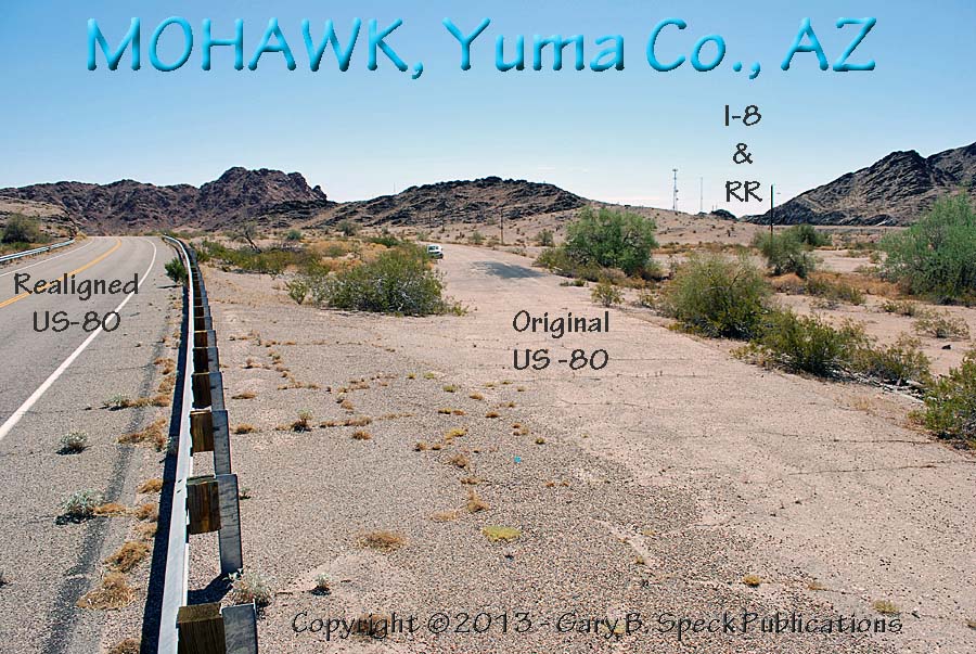
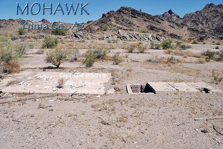
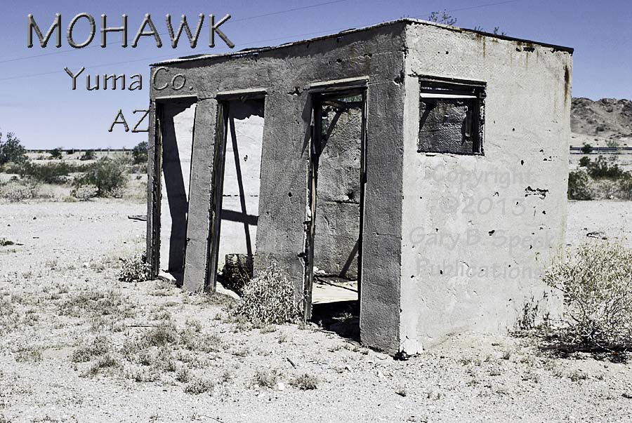
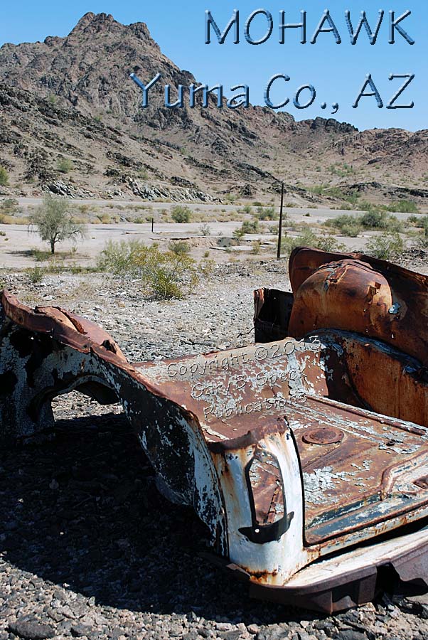
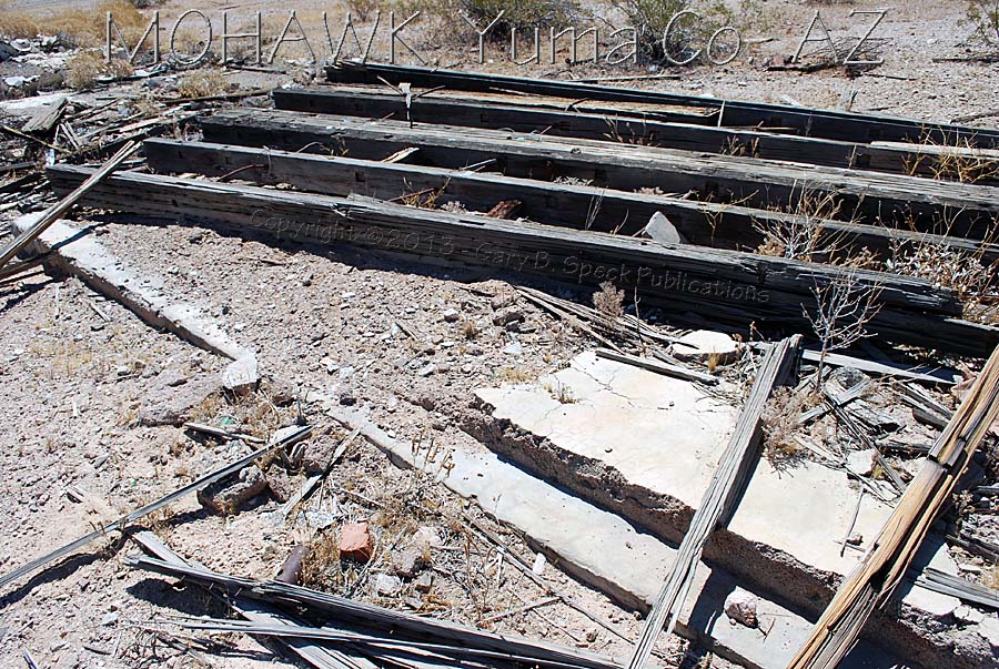
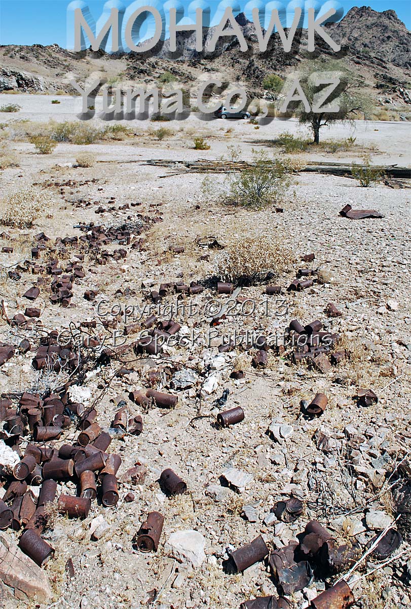
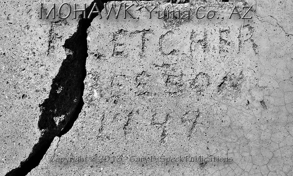
MOHAWK
The next stop named
mohawk, was my first major goal on this leg of the journey. While doing the preliminary research for
this trip, this site fascinated me.
When reviewing online aerial photos I could see what appeared to be
several foundation outlines and what looked like former
highway routings. Hmmm. Methinks
this was worth a stop. So. With my
heart still pounding from the canine reception at the last stop, I relished the
quiet of what was originally established as PETERMAN’S STATION, another Butterfield stage station. In the 1880s, the railroad station named
Crystoval
was established nearby. Then in 1898, the Tachna Post Office arrived and was
renamed Crystoval, operating until 1927, at which time it
returned to Noah as the Tacna Post Office (See Noah
– above.) Finally,
in 1905, a group of settlers from New York arrived and renamed the little
railroad town Mohawk.
This active
railroad town, embraced new technology, and in the 1930s, became a busy little
roadside community with some 120 people.
In July 2010, all that remained were a
restaurant slab, an old two-holer outhouse, a
forgotten car, a collapsed
billboard, lots
of rusty cans and memories
etched into the concrete, all rooted in a highway turnout just west of
the summit of Mohawk Pass. On the
surface not much remains, but by stopping, and really looking at the remains,
followers of Ghost Town USA can see
the flesh returning to the bones of this desiccated
town sitting alongside a dead highway, deep in the heart of
Southwestern Arizona’s desert.
CONTINUED in PART
2…
This
was our Ghost Town of the Month for August 2013.
PART 1: Yuma to Mohawk
PART 2: Mohawk
to Gila Bend
Click here to see more ghost towns in Arizona.
GPS
and Standard Township/Range locations for the sites featured above.
|
SITE NAME |
ELEV. |
LATITUDE |
LONGITUDE |
TOWNSHIP/RANGE |
|
Adonde |
246’ |
32.6611594 / 32°
39’ 40” N |
-114.1924390 / 114°
11’ 33” W |
NE¼ Sec 10, NW¼ Sec 11, T9S, R19W GSRM (Gila & Salt River Meridian & Base
Line) |
|
Antelope Hill (HILL) |
804’ (summit) |
32.7039358 / 32°
42’ 14” N |
-114.0157671 / 114°
00’ 57” W |
NW¼ Sec 28, T8S, R17W, GSRM |
|
Asher |
305’ |
32.6756032 / 32°
40’ 32” N |
-114.0735467 / 114°
04’ 25” W |
North end of Sec line 1 (east) & 2 (west),
T9S, R18W, GSRM |
|
Colfred |
331’ |
32.7044917 / 32°
42’ 16” N |
-113.9015963 / 113°
54’ 06” W |
NE¼ Sec 28, SW¼ Sec 27, T8S, R16W, GSRM |
|
Filibuster Camp |
225’ APPROX |
32.7042195 APPROX |
-114.1034889 APPROX |
NW¼ Sec 27, T8S, R18W, GSRM APPROX |
|
Filibuster’s Station |
300’ APPROX |
32.7086611 APPROX |
-114.0187740 APPROX |
SW¼ Sec 21, NW¼ Sec 28, T8S, R17W, GSRM APPROX |
|
Liguta |
233’ |
32.6744925 / 32°
40’ 28” N |
-114.2949421 / 114°
17’ 42” W |
NW¼ Sec 2, T9S, R20W, GSRM |
|
Mohawk |
560’ APPROX |
32.7288084 / 32°
43’ 43” N |
-113.7521517 / 113°
45’ 08” W |
Ctr
Sec 13, T8S, R15W, GSRM |
|
Mohawk Siding |
535’ |
32.7267144 / 32°
43’ 36” N |
-113.7552022 / 113°
45’ 19” W |
S-Ctr Sec 13, T8S, R15W,
GSRM |
|
Noah |
331’ |
32.6847694 / 32°
41’ 05” N |
-114.0221562 / 114°
01’ 20” W |
Sec line 32 (west)/33 (east), T8S, R17W, GSRM |
|
Owl |
443’ |
32.7291920 / 32°
43’ 19” N |
-113.7921480 / 113°
47’ 32” W |
NW¼ Sec 22, T8S, R15W, GSRM |
|
Tacna |
351’ |
32.6975472 / 32°
41’ 51” N |
-113.9535427 / 113°
57’ 13” W |
SE¼ Sec 25, T8S, R17W / SW¼ Sec 30,
T8S, R16W, GSRM |
|
Wellton |
246’ |
32.6728256 / 32°
40’ 22” N |
-114.1468821 / 114°
08’ 49” W |
NE¼ Sec 6, NW ¼ Sec 5, T9S, R18W, GSRM |
|
Wellton Army Airfield |
325’ |
32.6517149 / 32°
39’ 06” N |
-114.1046587 / 114°
06’ 17” W |
Sec 10, T9S, R18W, GSRM |
|
Historians
estimate that there may be as many as 50,000 ghost towns scattered across the
The Ghost Town
Guru's Guide
to the Ghost Towns of “STATE”™ These
original guides are designed for anybody interested in ghost towns. Whether
you are a casual tourist looking for a new and different place to visit, or a
hard-core ghost town researcher, these guides will be just right for you.
With over 30 years of research behind them, they will be a welcome addition
to any ghost towner's library. Thank you,
and we'll see you out on the Ghost Town Trail! For more information on
the ghost towns along this portion of old US HIGHWAY 80, contact us at
Ghost Town USA. E-mailers,
PLEASE NOTE: Due
to the tremendous amount of viruses, worms and “spam,” out there,
I no longer open or respond to e-mails with unsolicited attachments, OR
messages on the subject lines with “Hey”, “Hi”,
“Need help”, “Help Please”, “???”,
or blank subject lines, etc. If
you do send E-mail asking for information, or sharing information, PLEASE indicate the
appropriate location AND state name, or other topic on the
“subject” line. THANK
YOU! :o) |
IMPORTANT These listings and
historical vignettes of ghost towns, near-ghost towns and other historical
sites along this portion of US HIGHWAY 80 above are for informational
purposes only, and should NOT be construed to grant permission to trespass,
metal detect, relic or treasure hunt at any of the listed sites. If the reader of this guide
is a metal detector user and plans to use this guide to locate sites for
metal detecting or relic hunting, it is the READER'S responsibility to
obtain written permission from the legal property owners. Please be advised,
that any state or nationally owned sites will probably be off-limits to metal
detector use. Also be aware of any federal, state or local laws restricting
the same. When
you are exploring the ghost towns along US HIGHWAY 80, please abide by
the Ghost Towner's
Code of Ethics. |
Also visit: Ghost Town
Home
Page | Site Map | Ghost Town Listings
| On
the Road Again | Photo Gallery
| Treasure
Legends
CURRENT Ghost Town of the
Month | PAST Ghost Towns
of the Month
Ghost Towner's
Code of Ethics | Publications | Genealogy
| License Plate
Collecting
A few LINKS to outside webpages:
Ghost
Towns | Treasure
Hunting | License
Plate Collecting | Genealogy
***
THIS PAGE
FIRST POSTED: August 06
2013
***
This entire website, and all individual web pages
is
copyright
© 1998-2017
by Gary B Speck Publications
ALL rights reserved