GHOST TOWN USA
Proudly Presents
ANOTHER ONE BITES THE DUST
By
Ghost town hunting
is a fascinating hobby, but eventually you - the explorer - will find a place
that has been touted in books and articles and is a wonderful place to stop,
and so on. You then make a point to
visit, and guess what?
IT’S GONE!!! Or changed radically.
Unfortunately, this is
becoming an all too familiar occurrence as time slowly slips behind us. In my 40 years PLUS of exploring American
ghost towns I have been disappointed and have witnessed numerous sites
disappearing. Some have been minor sites
or single buildings, while others have been entire, well-known towns. SO, this behooves each of us to get out there
and photographically preserve what’s left!
With digital cameras having replaced film cameras, there’s NO EXCUSE to
not take a lot of photos of these places to document what is left, and the
changes being made, even in the short, but permanent term!
I’m not going to get
into the reason why places disappear, but most are because of us – mankind –
human beings - Homo sapiens. Granted
nature does take its toll, but nothing like we do. Today (2014) there is much ado about climate
change - a more politically correct term than global warming – supposedly
caused by our addiction to fossil fuels and carbon-based products (a topic I
will NOT broach here). But humans (and
nature) also cause other changes: changes that don’t make the daily news - the
disappearance of ghost towns being one glaring example. Of course this is much easier to document,
and it doesn’t make CNN or FOX News or even PBS. But for those of us invested in exploration
and the hobby
of ghost towning, it is just as important.
Once a ghost town has
disappeared, it’s gone forever, except in photographs and other memories. So, here’s the preaching part again. Get out there and document these places
before they are gonE!
Some of the greatest
casualties in my knowledge base include the following places that I have seen
disappear or suffer significant change.
After the name and state, I have listed the cause of the town’s or
structure’s demise. There are MANY
others but these are ones I am acutely aware of.
Any links incated thusly,
are links to our Ghost
Town Definitions page.
If you are not sure of what this word is, that page should hopely ‘splain it to you. Thanks (this was a reader suggestion a few
years back)
CENTRALIA, PENNSYLVANIA Human – accident - fire
I have NOT visited
Centralia, but did a lot of research while working on my most recent book: Ghost
Towns: Yesterday & Today.
The bottom line on this place is that it is, or should I say, WAS a coal mining
town. In 1930, nearly 2500 people lived
here, and in 2010 the population was 0.
What caused this mass desertion was an underground fire that began in
1962 with burning trash at the town dump, which had the unfortunate position of
being located adjacent to a mined coal seam.
HMMM. Fire, oxygen and fuel.
Sounds like a recipe for disaster.
It
was!
The
fire quickly ran underground and the burning coal seam underground has caused
the entire town to be shut down, evacuated and the buildings removed. Even the highway into town has been
rerouted. So, where thousands once lived
and worked is now an empty, uninhabitable wasteland. Wouldn’t it be great to see pictures of the
town in its prime?
Eagle Mountain, CALIFORNIA Human – intentional - Site
posted against entry
This class
C,
iron-mining company town is
located at the massive Eagle Mountain iron mine, tucked into a pocket on the
southeastern side of Joshua Tree National Park.
It was formerly accessible by County Road (CR) R2, north of Desert
Center, which itself is a slumbering road town in the heart of the desert,
along I-10
midway
between Indio and the Colorado River.
You can still make the journey, but the road is blocked and posted. Take a telephoto lens or telescope to view
the remaining buildings at this huge town site. See our Eagle Mountain page for
additional details.
EXPOSED
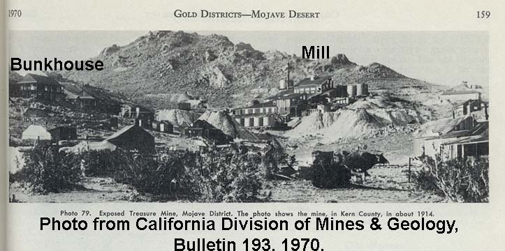
TREASURE MINING CAMP, CALIFORNIA Human – intentional - mining
This little Mojave Desert
mining camp was located west of State Highway
(SH) 14,
a few miles south of Mojave in the heart of Southern California’s Mojave
Desert. The mineral that created it,
destroyed it! I explored it pretty thoroughly
back in 1984 and really enjoyed my quality time with the crumbling buildings
and when I find the photos I took that day, will post them. One day a dozen or so years ago, I was
planning a trip to that area again, and couldn’t find the camp. Where it was, was a huge tailing pile from
an open pit
gold
mine. That pile also covered up the
neighboring mining camp of Desert Queen.
In fact, what was once known as Standard Hill, has also been pretty well
ground up and the gold has been extracted.
From what I understand, the magnificent stamp mill
that
stood in the camp had been relocated to the Friends of the Mojave Road’s museum
at Goffs. The mines on Standard Hill are not listed
in GNIS, so I have only given the
GPS info for Standard Hill below. See the map for the entire Mojave-Rosamond
Mining District, and a 1914
view of the mining camp. The
large, two-story bunkhouse is shown on the left, and the mill complex at the
right center.
FRONTENAC, Minnesota Human – intentional – partial
demolition of historic structure
This town has not
disappeared, but did suffer the partial loss of a major building. When we visited the town in the summer of
1998, the famous old hotel was having the entire rear portion demolished. From what I understand, the rest is still
standing, but it is unused at the present.
GRAFTON, Utah Human – intentional –
2 buildings removed - 1 burned and 1 collapsed
This town has not
disappeared, but did suffer the loss of two major buildings. In
July 1990, just to the west of the Louisa Russell home was
the remains of a burnt building, and across the entrance road to the west was a
crumbling log building. Both are long
gone, the sites now barren and unmarked.
SEE our GRAFTON page for additional
details of the town.
LITTLE LAKE,
CALIFORNIA
Human – intentional – complete site demolition
SEE our Little
Lake page for
details on this lost and nearly forgotten ghost town along US Highway 395 south
of Lone Pine and north of Inyokern.
LUDLOW, CALIFORNIA
Nature – accidental – partial collapse of major structure in earthquake
This town has not
disappeared, but did suffer the partial loss of a major building. On October 16, 1999 the magnitude 7.1 Hector
Mines Earthquake ripped through the Mojave Desert just a few miles away. The once-majestic, two-story concrete, Murphy
Brothers store suffered serious damage, the entire front portion
collapsing. As of 2007 it was still
standing, although fenced off.
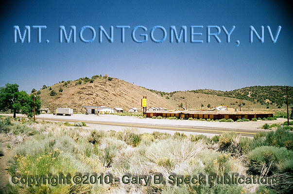
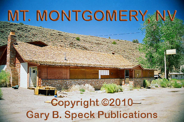
MOUNT
MONGOMERY,
NEVADA
Human – intentional – one building burned
I received the following E-mail from Daniel D. on
July 18, 2010.
“Someone
burned the old casino
down a few months ago. It is a total
ruin with just a few walls left. …The restaurant
you mention was in fact the first casino with some food
available.”
See PART
2 of our US
6 - On the Road pages for additional information
on this old road town.
NORTH SHORE, CALIFORNIA
Human – intentional – demolition of the motel building, complete renovation of
the yacht club into a museum (since relocated).
This
town has not disappeared, but did suffer the loss of a major building, and
extensive remodeling of another. SEE our North
Shore page for details on this old faded
resort town.
PICHER, OKLAHOMA
Human – intentional – closed by government due to serious pollution problems
This former zinc mining town in the
northeastern corner was declared a superfund site and has been abandoned. The Federal Government has purchased the
properties and evicted all Picher’s occupants.
Please be advised that accessibility here is subject to change and that
it is a dangerous location due to the undermining of the entire townsite by the lead mines.
If you do visit, please remain on the public roads. I visited Picher during our summer 2012 ghost
town tour and will be posting a page for this old town in the near future. Like Centralia, I also did a lot of research
on this town for its inclusion in my newest book: Ghost
Towns: Yesterday & Today.
SALTDALE, CALIFORNIA
Human – intentional – Site posted against entry
This former salt mining
and shipping center on the north side of Koehn Dry Lake has been posted against
entry. At the time of my visit in April,
2013, there were workers at the railroad grade, and numerous signs prohibiting
entry were located just north of the rail crossing.
SOUTHERN CROSS, MONTANA
Human – intentional - mining
SEE our SOUTHERN
CROSS page
for details on this lost ghost town. I
recently heard by a poster on the Ghost Towns
Yesterday & Today Facebook page that the site is still open and a few
buildings still remain.
TEMECULA HOT
SPRINGS, CALIFORNIA
Human – intentional - development
Bulldozers
took out this old hot springs spa in the 1990s.
Gotta have more houses!!! The site is actually now barren and sits
across the street from a housing tract.
THISTLE, Utah Nature – accidental -
flooding
SEE Part
6 of our “Tour Guide to the Ghost Towns Along U.S.
Highway 6” for the story of THISTLE.
Please note: In the above list, there are a lot of locations
from California. I’m not trying to claim
that California leads the nation in this phenomenon, I just happen to live in
and explore this state the most, therefore, I note
these changes quicker.
GPS
and Standard Township/Range locations for the sites featured above
|
SITE NAME |
ELEV. |
LATITUDE |
LONGITUDE |
TOWNSHIP/RANGE |
|
Centralia (Columbia Co., PA) |
1460’ |
40.8042541 / 40° 48’ 15” N |
-76.3405035 / 76° 20’ 26” W |
NOT
USED IN PENNSYLVANIA – Conyngham Township |
|
Eagle Mountain (Riverside Co., CA) |
1365’ |
33.8575137 / 33° 51’
27” N |
-115.4872075 / 115° 29’
14” W |
W½ Sec 1, all Sec 2, T4S, R14E, San Bernardino
Base Line & Meridian |
|
Exposed Treasure Mine Camp (Kern Co., CA) |
SEE Standard Hill |
35.007960 (approximately) |
-118.171563 (approximately |
NE¼
Sec 32, T11N, R12W, San Bernardino Base Line & Meridian |
|
Frontenac (Goodhue Co., MN) |
751’ |
44.5260787 / 44° 31’ 34” N |
-92.3321254 / 92° 19’ 56” W |
SW¼
Sec 3, SE¼ Sec 4, T112N, R13W, 5th Principal Meridian |
|
Grafton (Washington Co., UT) |
3665’ |
37.1672050 / 37° 10’ 02” N |
-113.0799425 / 113° 04’ 48” W |
N½ Sec 3, T42S, R11W, Salt Lake Baseline & Meridian |
|
Little Lake (Inyo Co., CA) |
3130’ |
35.9366936 / 35° 56’ 12” N |
-117.9067408 / 117°
54’ 24” W |
NW¼ Sec 17, NE¼
Sec 18, T27S, R38E, Mount Diablo Meridian |
|
Ludlow (San Bernardino Co., CA) |
1778’ |
34.7211004 / 34° 43’ 16” N |
-116.1600117 / 116°
09’ 36” W |
S½ Sec 5, N –Ctr Sec 8, T7N,
R8E, San
Bernardino Base Line & Meridian |
|
Mount Montgomery (Mineral Co., NV) |
6450’ |
37.8285428
/ 37°
49' 43" N |
-118.4309530
/ 118°
25' 51" W |
SE3
Sec 27, T1S, R32E, Mount Diablo
Meridian |
|
North Shore (Riverside Co., CA) |
-205’ |
33.5094710 / 33º 30’ 34” N |
-115.9230530 / 115º 55’ 23” W |
NW¼ Sec 34, T7S,
R10E, San
Bernardino Base Line & Meridian |
|
Picher (Ottawa Co., OK) |
820’ |
36.9870117 / 36° 59’ 13” N |
-94.8307845 / 94° 49’ 51” W |
Sections
20 and 21, T29N, R23E, Indian Meridian |
|
Saltdale (Kern Co., CA) |
1923’ |
35.3591276 / 35° 21’ 33” N |
-117.8875671 / 117°
53’ 15” W |
NW¼ of the NE¼
Sec 3, T30S, R38E, Mount Diablo Meridian |
|
Southern Cross (Deer Lodge Co., MT) |
6972’ |
46.2102031 / 46° 12’ 37” N |
-113.2364462 / 113° 14’ 11” W |
SW¼
Sec 4, T5N, R13W, Principal Base Line and
Meridian |
|
Standard Hill (Kern Co., CA) |
3123’ |
35.0071939 / 35° 00’ 26” N |
-118.1742422 / 118° 10’ 27” W |
N½
Sec 32, S½ Sec 29, T11N, R12W, San Bernardino Base Line & Meridian |
|
Temecula Hot Springs (Riverside Co.,
CA) |
1093’ |
33.5539148 / 33º 33’ 14” N |
-117.1683658 / 117°
10’ 06” W |
NW¼
Sec 24, T7S, R3W, San Bernardino Base Line & Meridian |
|
Thistle (Utah Co., UT) |
5043’ |
40.0371781 / 40° 02' 14" N |
-111.5288024 / 111° 31' 44" W |
Corner
Secs 28, 29, 32 & 33, T9S, R4E, Salt Lake
Baseline & Meridian |
***************
Also visit: Ghost Town USA’s
Home
Page | Site Map | Ghost Town Listings
| On-the-Road
Again | Photo Gallery
| Treasure
Legends
CURRENT Ghost Town of the
Month | PAST Ghost Towns
of the Month
Ghost Towner's
Code of Ethics | Publications | Genealogy
| License Plate
Collecting
A few LINKS to outside webpages:
Ghost
Towns | Treasure
Hunting | License
Plate Collecting | Genealogy
***

***
THIS PAGE
FIRST POSTED: June 05, 2010
LAST UPDATED: August 10, 2014
**************
This
website and all information posted here-in is
copyright
© 1998-2017
by Gary B Speck Publications
ALL rights reserved