 I
love Rame
I
love RamePictorial Aerial Photographs around Plymouth-England~Taken from 2,000 feet down to 250 feet (High Quality 6 cm sq. negative/Hasselblad)
MAKER-WITH-RAME PENINSULA
I
love Rame


another "content over style" heritage web page from Steve Johnson`s www.cyberheritage.co.uk
[email protected] - use these images freely - all taken by me and given to Public Domain to aid research, schools, and local history ~ all taken during 1980-1982 ~ a 100 MB downloadable content site ~ maximum size of image 350k jpeg

The Maker with Rame Peninsula, Penlee Point, Rame Head, Amory Bight, Crafthole, Portwrinkle, Downderry, Cawsand and Kingsand, Mount Edgecumbe, Cremyll, Torpoint, Wilcove, Millbrook, Southdown, The Tamar Estuary, Trevol and St. John`s Lake, the Eddystone Lighthouse - all late 1970`s to 1980`s
Antony House, the carrier Ark Royal awaits the cutter`s torch at anchor in the Hamoaze
Cawsand and Kingsand....1.......2........3..........4.........5...........6............7...........8..........9..maybe better scans A....B....and a very different one! this is a ground view of the old pilchard cellars at Kingsand, taken in the early 1990`s it is included for interest as on one of my other web pages there are some shots here in the 1920`s (see Plymouth in Old Photographs; picnics, waterfront, The Hoe, Plymouth Sound, beside the seaside beside the sea, fishing vessels, Kingsand)
Cremyll (and Mashfords).....1......2.......3........4..........5.. ...Mashfords Yard and again Empacombe
Stonehouse - Plymouth and The Royal William Yard and the fortifications at Mount Wise overlooking Stonehouse Pool between Admiral`s Hard and Cremyll
Mount Wise, showing Admiralty, formerly Govermnent House, was Admirals Naval HQ, (it`s now for public sale!!) and again showing Stonehouse Creek Here is Devil`s Point and the Royal William Yard the entrance to the Hamoaze a vertical view of the Royal William Yard and a little to the south Views of the Royal William Yard......1........2.........3...........4.............5
Devonport Dockyard, North Corner and the area around Durnford Street Here is a long shot of Durnford Street
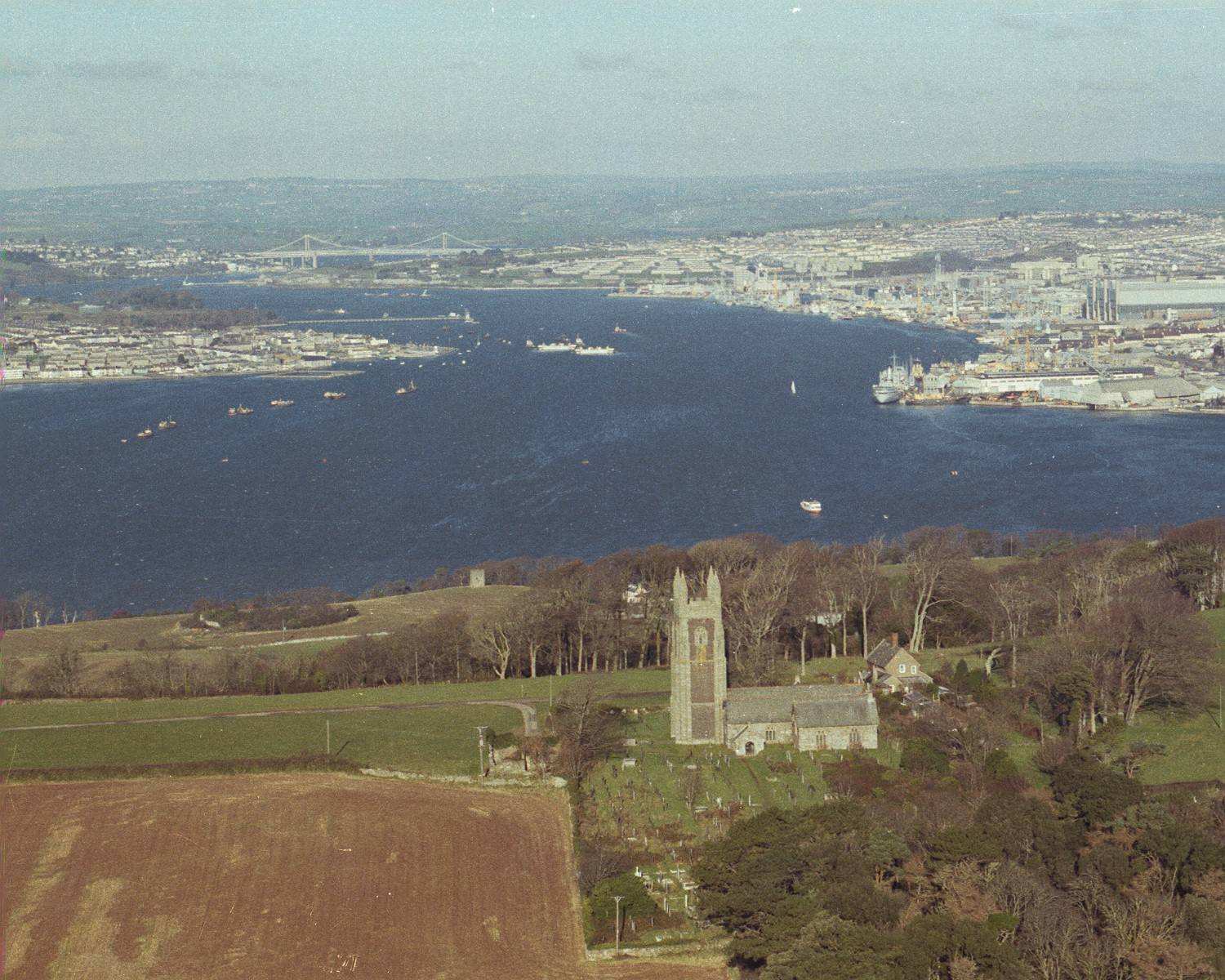
Maker Church, seen from the south and looking up The Hamoaze to the Devonport Naval Base and Torpoint. Aerial close-up of Maker Church
Millbrook Millbrook Millbrook showing Southdown......and similar Southdown St. John`s Lake St. John`s Lake St. John`s Lake Trevol and St. John`s Lake Trevol and St. John`s Lake Trevol and St. John`s Lake Trevol and St. John`s Lake Trevol and St. John`s Lake (see Plymouth History - Cannon Balls & Penlee & Rame Batteries )
Penlee Point, showing the Trinity House buildings, and the Fog Horn (now gone)....the long top to bottom "scar" is the slope cut to pull the large RML (RIFLED MUZZLE LOADING) guns from the tiny rocky "harbour" (it`s the huge steps-like construction at centre left) that was built on the tide line to receive them from sea-borne delivery....up to the gun positions on the top of the Penlee headland called "Penlee Battery." Just below the arched "Queen Adelaide's Grotto" can be seen some of the remains of this once huge and famous Coastal Defence Battery. These are the Electric Light - a type of searchlight synchronised to small Q.F. (Quick Firing) guns. Sadly these have now also gone.
These two views of Penlee Point show the rocky cove "Lady Cove" (by the little rocky "island") which is an underwater site of some of the cannon of the 17th century wreck of HMS Coronation. The small island-like copse are "brakes" designed to protect early agriculture from wind damage. The brake on the right is Middle Barton Brake and is a superbly silent place to picnic among the wind rustled leaves and crashing waves. Way back in 1976 during a visit there I stumbled upon the relics of a 19th century picnic - plates, Codd bottles - but buried under a few inches of non-decomposed dead leaves!..a century`s worth!! see Plymouth - Rame way, an early 20th century picnic through Mt. Edgecumbe up to Rame Head in S.E. Cornwall
Here we see the coastal woodland along the west side of Cawsand Bay. The constructions seen are a 19th century fortification known as Pier Cellars, currently a Royal Naval Sea Cadet Centre and an Anti-Magnetic De-Gaussing Station. This was in it`s heyday, a shore firing position for the early guided Brennan Torpedo.
The Eddystone Lighthouse, also known as The Douglas Lighthouse.........1........ .2.............3..............4................5................6 The stump on the left is the remaining base of Smeaton`s Tower, the structure that was the Eddystone Light before the Douglas tower. Smeaton`s Tower was dismantled due to erosion of the rock on which it stood, and is now rebuilt and open to the public on Plymouth Hoe.
Rame - Rame, the very sound of the name has a special meaning for me. Ever since I was a boy, say at 13, when summer school holidays became summer away days at Rame - angling and fishing on the ( it`s me in 1969!! at Eastern Gear...cooking baked beans) rocks, exploring Rame Church and Penlee Coastal Defence Batteries, sitting in out of the rain in Rame Church (my son is here in the late 1980`s), sitting in the ancient pews and feeling the silence of the wind running across the steeple - of playing one-fingered the harmonium - of sheltering in its dark and protective aisle on a stormy night as a night fishing session became too much - of passing time sitting in the shade of the Lych Gate. ( and so many years later my son is there in my shadow) Here I wait more than a quarter of a century ago at Admiral`s Hard for the Cremyll Ferry across to Mt. Edgecumbe, enroute to Rame. Here my pal and school friend Phil Byrne shows off a nice wrasse and starts the cooking fire.
Of climbing down to Eastern Gear as a child in the autumn of 1969, of trying to reach the beach at the cliff base on spring tide low waters - and of doing it all again with my very own son (Dominic) some 25 years later.
Of catching wrasse in 1969 and releasing them in the natural rock pool aquarium of a Rame tide-pool at Eastern Gear, my son in middle of shot. My son Dominic and his friend Adam land a pollack as the sea fills, refreshes and cleans out our rockpool fish tank. And doing it all again in the 1990`s with Dominic. Here is my son and a big wrasse!
The niches and points on the rocks are just as they were in my childhood.
The view is still superb in modern times as we look from Rame Head to Penlee Point.
Rame is silent and unchanging. Sheltering in St. Michael's Chapel atop the Rame Headland and watching the forks of lightening strike down on a summer nights storm when the air was thick with the shadows of times past - or taking my little son ( as was - he is now grown!) and searching for silver sixpencees hidden among the crags and holes that make the walls of St. Michael's Chapel - secreted money and memories from an era now only a memory. My young son ambles around Rame Chapel.
Of seeing the sun set - a golden red orb reflected in the glass sea of a calm Whitsand`s Bay as a school of porpoises gambled in the bay, all now not just a memory, but my treasured memory.
Of the days when Rame Barton was neglected and the drive overgrown and milk churns stood awaiting a collection. Of days when military constructions stood silent under the gaze of Rame Head.
Of walking the coast path from Penlee Point to Rame Head and stopping by a country stile.
.....And even kipping down on the cliff face with my pal Rob Legge ...this is him here...in 1969 after an all-night fishing stint at Rame...and this is me going up the pole at a shoreline boundary fence for Penlee Battery.
(this image here is a rarely seen painting of an artist`s impression of Whitsand`s Bay Battery - close to Rame..it hangs in the bar of Whitsands Bay Holiday Park..which is itself within the walls of Whitsand`s Bay Battery..to whom thanks are due)
The "Power and the Glory" of Rame (Church and Manor) - seen from the air in 1981-2
Rame Church.. Rame Church... Rame Church... Rame Church... Rame Church.. Rame Church... Rame Church... Rame Church...Rame Church ...Rame Church and Rame Vicarage....Rame Church and Rame Vicarage....Rame Church and Rame Barton.....Rame Church and Rame Barton....Rame Church and Rame Barton.....Rame Church and Rame Barton.....aerial view showing Rame Vicarage....aerial view showing Rame Vicarage.....showing Penmillard Farm and the road from Cawsand to Rame....showing Penmillard Farm......Rame Head itself surmounted by St. Michaels`s Chapel....Rame Head itself surmounted by St. Michaels`s Chapel....Rame Head itself surmounted by St. Michaels`s Chapel.....Rame Head itself surmounted by St. Michaels`s Chapel....showing Coast Guard Cottages, as were....showing Rame Coast Guard lookout-as was( I used to ask for a drink of water here sometimes after the strenuous climb up the cliff with the prospect of a walk back to Cremyll)
This now is a list of views of Rame Church, Rame Barton, Rame Vicarage and Penmillard Farm - to be the most perfect of wild and ancient places. Enjoy 1................2.................3................4................5...............6...............7.....
..........8...................9..............10...................11.............12................13 colour, shows the lot wow!
.......more colour and all wow!!....14.....................15.....................16........................17.................18......
.....19................20.................21...............back to black and white now........22.....................23.................24.....................25..................26......................27..
..............28....................29.....................30........................31.....................32
.......33....................34......................35.....................36
Rame Head itself surmounted by St. Michaels`s Chapel...Eastern Gear is the small beach area at the centre of photo....and again, with Eastern Gear at bottom left...similar.....similar but showing Amory Bight at centre to right and Eastern Gear at left
Queener Point, close by Rame, to it`s west, with Polawn Fort a little further along westwards into Whitesand`s Bay
Downderry is a seaside village set within the span of Whitsands Bay. Downderry, Portwrinkle, and Crafthole.....I get confused where one ends and the other starts....I think that Crafthole is a little inland, whatever, enjoy these photos...which one is this?
Tregantle is a superb sandy beach in Whitsand`s Bay (note military rifle ranges at top of cliff associated with Tregantle Fort). Along the cliff road are many holiday chalets
In the late 1980`s to early 1990`s, World War II beach defences were brought to the surface here by the storms - with an odd mine or two!!
Mt. Edgecumbe Park
Picklecombe Fort - now flats.....Picklecombe Fort - now flats..and similar ...and similar again...and a long view ..Picklecombe Fort - now flats Huntsman`s Cottage close to Picklecombe Fort.....and a closer view
Mt. Edgecumbe House and Barn Pool Mt. Edgecumbe Mt. Edgecumbe`s Orangery ... and again Mt. Edgecumbe and the old D-Day embarkation beach at Barn Pool ...and again (known as Chocolate Box Hards) (see Plymouth History - D-Day & Home Guard ) Mt. Edgecumbe Mt. Edgecumbe Mt. Edgecumbe Mt. Edgecumbe Mt. Edgecumbe Mt. Edgecumbe Mt. Edgecumbe Mt. Edgecumbe House Mt. Edgecumbe House Mt. Edgecumbe Mt. Edgecumbe Mt. Edgecumbe Mt. Edgecumbe Mt. Edgecumbe a modern ground view from the late 1980`s of World War II antisubmarine defences - now gone and consigned to history
LOOKING ACROSS TO MT.EDGECUMBE FROM ABOVE MILLBAY DOCKS......1..........2..
PLYMOUTH SOUND FROM THE AIR: looking along the Hoe, from over the Hamoaze
AROUND TORPOINT: Wilcove Wilcove Wilcove Wilcove Wilcove
THE OIL TERMINAL AT THANKES
TORPOINT ITSELF: Torpoint and the Ballast Ponds Torpoint and Ballast Ponds Torpoint and Ferry Torpoint and Ferry Torpoint and Ferry Torpoint and Ferry Torpoint and Ferry Torpoint and Ferry Torpoint and Ferry Torpoint Torpoint Torpoint Torpoint Torpoint Torpoint Torpoint Torpoint Torpoint Torpoint - away from sea and Ferry
PLUS " The Melancholy Bride of Rame Church " if you love Rame, you`ll love this!

![]()
In 1980 I set about forming a wedding photography business. I need some samples of my work to show potential customers - but had none...so I set up a fake wedding with a pretend bride. All I can remember is that she was called Cathy and had worked in a Plymouth restaurant of the time that was called the "Walrus and Carpenter."
I hired a 1920`s style wedding dress, an orange blossom head-dress and I took her to where else but Rame Church. The photos were superb and my business was a hit - I took brides to "locations" and not just the Church or Register Office - cornfields, woodlands, beaches with crashing surf all saw Steve`s brides! I used to get the bride to wear wellington boots under her dress ( supplied by me!) for the shoot!
The photos of Cathy were melancholy and beautiful,at the Church and Lych Gate, in a cornfield and at her dresser by her mirror!
My memories and deep feelings for Rame helped me make these images, which will soon be a quarter of a century old, and now Cathy must be...how old?! Never!
RETURN TO MAIN AERIAL INDEX PAGE
 "Far above the
Clouds" Steve Johnson`s "Cyberheritage" original aerial
page of views of Plymouth, Rame, Penlee, Plymouth Sound, Dartmoor, South Hams, Bigbury,
Salcombe, Erme and Avon estuaries - and much more - taken on 35mm colour slide and
negative stock from 1975 to 1981~an additional 50MB site
"Far above the
Clouds" Steve Johnson`s "Cyberheritage" original aerial
page of views of Plymouth, Rame, Penlee, Plymouth Sound, Dartmoor, South Hams, Bigbury,
Salcombe, Erme and Avon estuaries - and much more - taken on 35mm colour slide and
negative stock from 1975 to 1981~an additional 50MB site ![]()
link to another 100 plus sites like this - all with huge amount of useful and print-out-able downloadable content! www.cyberheritage.co.uk
Contacting Steve Johnson: Steve lives in Plymouth England. I get about 100 e-mails per week, (from over 100 sites) every week from you my visitors. Where I can help I try always to reply, if I am not able to help, I do not reply, allowing me to put my efforts into those that I can help. If you are in the United Kingdom, please phone me on 01752 772699 at any reasonable time rather than by e-mail with your query, you will be helping me, yourself and many others. Thank you for your co-operation.
this web site is brought to you by the www.stevejohnson.org.uk