Ghost Town
Guide to the Ghost Towns of
“The
Do you have Gary’s Ghost Town books?
Dust in the Wind - A Guide to
American Ghost Towns GHOST
TOWNS: Yesterday & TodayTM Become a friend of the book on Facebook ***
Return to Ghost Town USA’s State Listings
*** Visit Ghost Town USA’s Ghost Town of
the Month *** Visit Ghost Town USA’s Home Page *** Visit Ghost Town USA’s Photo Gallery *** Ghost
Town USA’s Site Map
*** Send E-mail to Ghost Town USA. *** Western & Eastern
Treasures Ghost Town USA Column Index for Idaho |
The
state of Idaho is rich in natural resources and scenery, and has been drawing
people to its high mountains and wide rich river bottoms for nearly 200 years.
Fur traders first discovered the Gem State in the 1830s and established fur
trading enters here. When migration to Oregon began in the 1840s and the
California Gold Rush after 1848, southeastern Idaho became an important
traveling area, especially along the Snake River. In the early 1860s gold
was discovered in the mountains to the north of the Snake River basin, and
all bets were off. Idaho then enjoyed boom after boom, and rush after rush as
the rich deposits of gold, silver, copper and other minerals were discovered
and exploited. Mining towns popped up overnight, boomed, and disappeared as
the miners went off in search of another rainbow. Today, because of the
low population, and the ruggedness of some of the locations, Idaho has many
remaining ghost towns and old mining camps still available for a visit.
HOWEVER, many are located in the backcountry and a four-wheel drive vehicle
or hiking are required to visit them. Agriculture also played
an important role in development of a number of ghost towns. The southern
part of the state has wide, rich river lands that are amenable to farming,
and during the last few decades of the 19th century and the first couple in
the 20th, many farming communities were established to serve these agrarian
pursuits. However, as is typical in most farming areas (especially as seen in
the Great Plains states), the advent of improved transportation and loss of
the small "mom & pop" farms to agricultural conglomerates have
doomed many of these towns to ghost hood. Idaho is rich in ghost
towns, and a lifetime could be spent pursuing all of them. Listed below are
33 locations to get you started. PLEASE NOTE: Where photos are indicated thusly, please use your browser’s
“BACK” button to return to page with the photo link. More photos will be added over time. |
BAYHORSE
|
Custer Co. |
This class C silver
mining town is located on Bayhorse Creek Road,
along north side of Bayhorse Creek, five miles west
of SH 75 at a point seven miles south of Challis. The mines were discovered
in 1877. A smelter, stamp mill and six charcoal kilns were built to process
the ore. The main street was lined with wooden saloons, boarding houses,
stores and other businesses. In 1893 silver was demonetized and the economy
took a tumble, taking Bay Horse with it. By the early 1920s, the town was
deserted. Wooden buildings still stood in the 1980s. A cemetery is located west of the charcoal
kilns, which are located west of town. ·
W-Ctr Sec 2, T12N, R18E, BM
(Boise Base Line & Meridian) ·
Latitude:
44.3976983 / 44° 23’ 52” N ·
Longitude:
-114.3117306 / 114° 18’ 42” W Cemetery:
·
E-Ctr Sec 3, T12N, R18E, BM ·
Latitude:
44.398161 ·
Longitude:
-114.319332 Coke Ovens: ·
E-Ctr Sec 3, T12N, R18E, BM ·
Latitude:
44.397639 ·
Longitude:
-114.315469 |
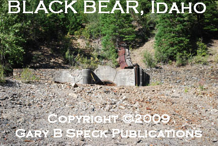
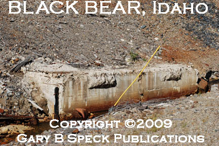
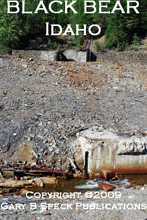
BLACK BEAR
|
Shoshone Co. |
Part of the Gem to
Burke strip of mining camps in the canyon northeast of Wallace, Black Bear in
2009 consisted of a handful of old mobile homes and a few cabins. At the east end of “town” is a concrete
walled mine adit (entrance) and along
the creek north of the road is a large concrete foundation. It is located 1.0 mile northeast of the
large brick assay office in Gem and 2.2 miles southwest of the huge mill
building in Burke. The mine adit is 0.1 mile northwest of the cabin cluster on the north side
of the bend in the road, north of, and above the creek. ·
SE¼ Sec 8, NE¼ Sec 17,
T48N, R5E, BM ·
Latitude: 47.5160407 / 47° 30’ 58” N ·
Longitude: -115.8523830 / 115° 51’ 09” W ·
Mine adit
shown in photo: 47.519230, -115.849092 |
BONANZA
|
Custer Co. |
This class C mining
town is nine miles north of Sunbeam, which is on SH 75, 44 miles southwest of
Challis. Bonanza was founded in 1876,
and four years later boasted 1500 people and a busy main street lined with
businesses. Some buildings still remain. This is
one of the towns featured in my newest book, GHOST
TOWNS: Yesterday & TodayTM. ·
NW¼ Sec 17, T12N, R15E, BM ·
Latitude:
44.3704682 / 44° 22’ 14” N ·
Longitude:
-114.7278568 / 114° 43’ 40” W |
|
Shoshone Co. |
Anchoring the eastern
end of the Gem to Burke strip of mining camps seven miles northeast of EXIT
62, north of I-90 at Wallace, Burke is a true gem of a ghost town. Ruins include the massive Hecla Mine
complex and a small row of commercial buildings. See our BURKE
Page for more details & photos. |
|
CAMAS STAGE STATION
|
Jefferson Co. |
A class A
stage coach station that was the site of a lost treasure legend. The station
was located where the stage road crosses Camas Creek. A stage full of gold is
said to have been robbed and the gold hidden near a lake on the south side of
Camas Creek, south of the station. In the meantime, the station has
disappeared also. Possibly at or near
the community of Camas, which just over a half mile east of I-15, about 35
miles north of Idaho Falls. CAMAS: ·
SE¼ Sec 21, T8N, R36E, BM ·
Latitude:
44.0074083 / 44° 00’ 27” N ·
Longitude:
-112.2210921 / 112° 13’ 16” W |
CENTERVILLE
|
Boise
Co. |
2
SITES ·
NEW CENTERVILLE: Now
a scattered class D
agricultural community at the junction of the Placerville Road and the Pioneerville Road west of Idaho
City in the heart of the Boise Basin. It is just scattered homes, mobile
homes and any semblance to a town is gone. ·
OLD CENTERVILLE: Old
class B
gold mining town on Grimes Creek, three miles north of New Centerville. I was
told by a local that “You don’t want
to go there.” It is north of New Centerville on a graded dirt stage road that
follows Grimes Creek
north to Pioneerville. It once had 3000 people and had a main street lined
with all the necessary buildings to support that many folks. Only rubble and
the cemeteries remain. See our Boise
Basin page for
additional details of this and other towns in this historic gold mining area. |
CHESTERFIELD
|
Caribou
Co. |
Founded in 1881, this wonderful little class C/F Mormon agricultural
ghost town is due east of Pocatello, 15 miles north of US 30, at a point 12
miles west of Soda Springs. The
buildings are being restored to their original appearance by Mormon
missionaries. Several buildings are open to the public (free), and docents
will guide you through the museum. The Chesterfield
Foundation maintains
a fascinating website about the town. This is
one of the towns featured in my newest book, GHOST
TOWNS: Yesterday & TodayTM. See our CHESTERFIELD Page for more details & photos. |
|
|
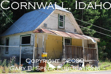
Shoshone Co. |
Part of the Gem to Burke
strip of mining camps in the canyon northeast of Wallace, Cornwall in 2009
consisted of a handful of old mobile homes and a few cabins. It is located 2.0 miles northeast of the
large brick assay office in Gem and 1.1 miles southwest of the huge mill
building in Burke. ·
SW¼ Sec 9, T48N, R5E, BM ·
Latitude:
47.5185410 / 47° 31’ 07” N ·
Longitude:
-115.8376606 / 115° 50’ 16” W |
CUSTER
|
Custer Co. |
A class C gold
mining town on the north side of Yankee Fork Creek, two miles northeast of
Bonanza, 26 AIR miles southwest of Challis on Yankee Fork Road. A museum in
the old school house (operated by the Forest Service) and a few buildings are
all that remain of this one-time gold camp. Custer was founded in 1876,
shortly after General George A. Custer’s defeat at the ·
NE¼ Sec 9, T12N, R15E, BM ·
Latitude:
44.3874133 / 44° 23’ 15” N ·
Longitude:
-114.6959118 / 114° 41’ 45” W |
De LAMAR
|
Owyhee
Co. |
A class C silver
mining town is along ·
NW¼ Sec 4, NE¼ Sec 5, T5S, R4W, BM ·
Latitude:
43.0243249 / 43° 01’ 28” N ·
Longitude:
-116.8315175 / 116° 49’ 53” W |
FORT HALL
|
Bannock Co. |
This class C/F
reconstructed ($)
replica of the original Fort Hall is located on US 30/91, a mile north of
I-15 Exit #67, in southern Pocatello.
It was built in the 1960s and is operated as a museum. Click here to go to their webpage. The original site is
marked by a historic marker and is located along the south side of the Snake
River about 200 yards south of the county line, just north of the river’s
inlet on the American Falls Reservoir northwest of Pocatello. The first site was originally
established in 1834 by “Nathaniel J. Wyeth and named after one of his
financial backers - Henry Hall of Boston. Several years later (1837) Wyeth
sold the fort to the Hudson's Bay Company and Thomas McKay of HBC took it
over.” (This section contributed by Dr. JoAn Dilweg, Aug 31, 2010) A second Fort Hall was
built about 25 miles from the original site and operated as a military post
and important stopping point on the Oregon Trail. It was also the point at
which many California bound emigrants split off and headed south towards
California. It was in use from 1870-1883, and the old buildings were turned
over for use as a school for Native American children. ·
NE¼ Sec 6, T5S, R33E, BM ·
Latitude:
43.0201915 / 43° 01’ 13” N ·
Longitude:
-112.6347089 / 112° 38’ 05” W |
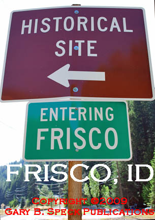
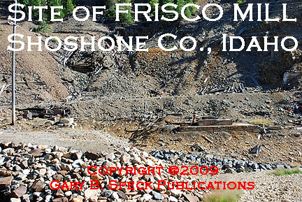
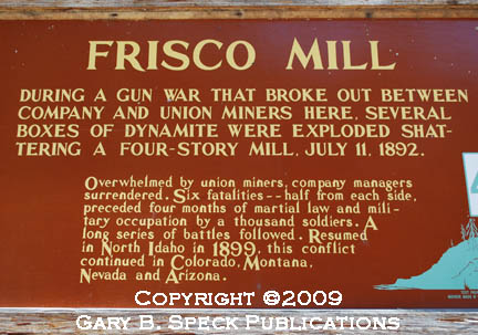
FRISCO
|
Shoshone Co. |
Part of the Gem to
Burke strip of mining camps in the canyon northeast of Wallace, Frisco in
2009 consisted of a handful of old mobile homes and a few cabins, along with
the massive
ruins
of the old four-story Frisco
Mill
on the south side of the creek, south of the road. The mill is signed with
a large state historic marker sign.
The mill sign is located 0.6 miles northeast of the large brick assay
office in Gem and 2.3 miles southwest of the huge mill building in
Burke. ·
NE¼ Sec 18, T48N, R5E, BM ·
Latitude:
47.5121518 / 47° 30’ 44” N ·
Longitude:
-115.8593273 / 115° 51’ 34” W |
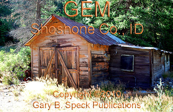
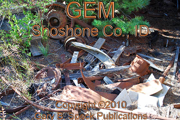
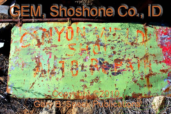
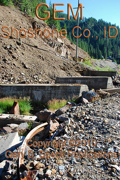
GEM
|
Shoshone Co. |
This little class D silver mining town anchors the western
end of the Gem to Burke strip of mining camps 3.5 miles northeast of EXIT 62,
north of I-90 at Wallace. It is a
strung-out little town that has more past than it does present or future. Little remains of its glory days of a
century ago. About all that remains
are a burnt-out
cabin, an old automobile repair garage
(with rubble
and an old
sign hidden in the weeds), the Hecla Mining Company assay
office and metallurgical laboratory, ruins
of a couple of mills
and other relics of the past. These
are all offset by the string of cabins and mobile homes housing the present
residents. ·
Ctr Sec 18, T48N, R5E, BM ·
Latitude:
47.5082627 / 47° 30’ 30” N ·
Longitude:
-115.8679385 / 115° 52’ 05” W
|
GILMORE
|
Lemhi
Co. |
This class C silver
mining town is west of SH 28, 18 miles south of Leadore.
Gold was discovered here in 1873, but it wasn’t until 1889 when silver-lead
ores were worked, the town boomed. The mines produced over $12,000,000 in
silver and gold by the 1930s, when the town died. Many buildings remain. ·
Ctr Sec 17, T13N, R27E, BM ·
Latitude:
44.4588049 / 44° 27’ 32” N ·
Longitude:
-113.2697472 / 113° 16’ 11” W |
HELENA
|
Adams Co. |
This class C
copper mining town was named after ·
SW¼ Sec 12, T21N, R3W, BM ·
Latitude:
45.1701582 / 45° 10’ 13” N ·
Longitude:
-116.6523664 / 116° 39’ 09” W |
IDAHO
|
Boise
Co. |
This is a touristy, must-see
class E
gold mining town. Many old wood and brick buildings remain from the Boise
Basin gold rush of 1863 when See our Boise
Basin page for
additional details of this and other towns in this historic gold mining area. |
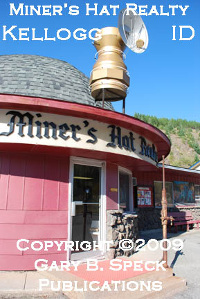
KELLOGG
|
Shoshone Co. |
Right up front, I’m
going to categorically state that Kellogg is NOT A GHOST TOWN. However, it IS an old historic mining town, and the only reason it is posted
here is due to that fact and a few pictures I wish to share. On August 10, 2009, I sort-of visited
Kellogg when I spent some quality camera time with the towns lining Canyon
Creek, northeast of Wallace (Gem-Burke).
Right off the north side of I-90 at EXIT 51, I took a few pictures of
a quaint real estate office on the north side of Kellogg that was shaped like
a miner’s
hat, was named Miner’s
Hat Realty, and had a reproduction of a miner’s carbide
lamp on the roof. Real estate office: ·
NW¼ Sec 5, T48N, R3E, BM ·
Latitude:
47.536316 ·
Longitude:
-116.113279 |
|
LEESBURG |
Lemhi
Co. |
This class C placer
gold mining is located on a rough four-wheel-drive road in the Salmon
National Forest, 14 miles northeast of Cobalt, and 8 miles west of US 93 at a
point five miles south of Salmon. Leesburg began in 1866, and quickly was
home to 3000 folks, and over 100 businesses. A cemetery and a number of
wooden buildings remain along what used to be the main street of this
isolated community. ·
NW¼ Sec 21, T22N, R20E, BM ·
Latitude:
45.2238080 / 45° 13’ 26” N ·
Longitude:
-114.1139647 / 114° 06’ 50” W |
|
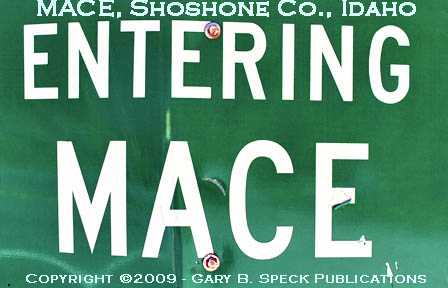
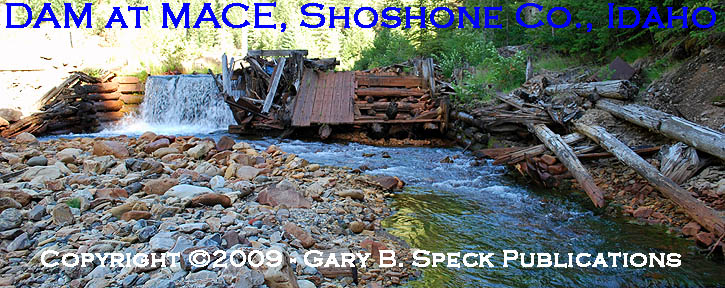
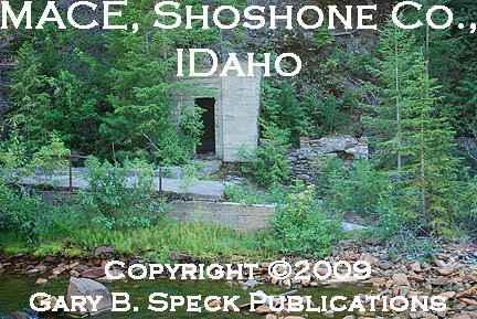
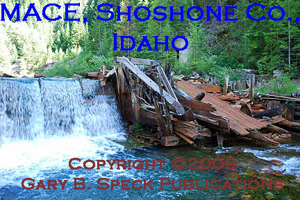
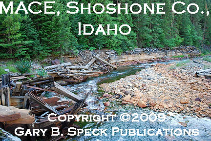
MACE |
Shoshone Co. |
Part of the Gem to
Burke strip of mining camps in the canyon northeast of Wallace, Mace in 2009
consisted of a sign,
a dam
and some ruins
and rubble
along the south side of the creek. There were no cabins noted. The sign is located 2.3 miles northeast of
the large brick assay office in Gem and 0.6 miles southwest of the huge mill
building in Burke, and just west of the western end of Burke. ·
SW¼ Sec 9, T48N, R5E, BM ·
Latitude:
47.5182635 / 47° 30’ 06” N ·
Longitude:
-115.8221047 / 115° 49’ 20” W |
|
MINERAL
CITY |
Washington Co. |
This class B
1880s silver mining town can only be reached by four-wheel drive road. It is due west of |
|
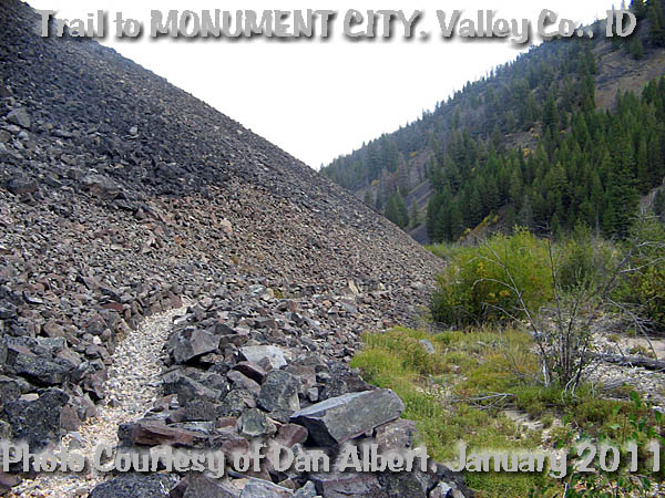
MONUMENT
CITY |
Valley
Co. |
Located in the Frank
Church wilderness, this old mining town is probably along Monumental Creek or
west or northwest of Thunder Mountain, a dozen or so AIR miles northeast of
Stibnite, and was probably part of the Thunder Mountain Gold Rush
(1902-1908). A rocky
trail leads to the site where rock-walled ruins
of cabins and fireplaces
remain of this small, early 1900s mining camp. Exact location not determined as it is not
listed in GNIS. Photos Courtesy of Dan Albert, January 1, 2011 |
PEARL
|
Gem Co. |
A class D
tough little gold mining camp east of Emmett and due north of Boise. It
strings along a canyon along Willow Creek. ·
SE¼ Sec 15, T6N, R1E, BM ·
Latitude:
43.8557215 / 43° 51’ 12” N ·
Longitude:
-116.3173499 / 116° 19’ 02” W |
PIONEERVILLE
|
Boise
Co. |
AKA Fort Hog ‘em and Pioneer City, this 1860s era Boise Basin gold rush
town that once had 2000 people, has faded to a scattered community hidden in
the hills eight miles northwest of New Centerville. The road in is a rough
road (old stage road), and I was advised by locals in New Centerville that it
was too rough for my minivan, so we didn’t go. (GBS) See our Boise
Basin page for
additional details of this and other towns in this historic gold mining area. |
PLACERVILLE
|
Boise
Co. |
Only 20 or so permanent
residents still live in this quaint little class D
gold mining town northwest of New Centerville. The buildings cluster around a
central square, and at the time of our visit nothing was open. In 1863 things
were way different. 5000 people along with well over 300 buildings marked the
town. Today many summer cabins lie around the edges of town. See our PLACERVILLE page for
additional details. |
ROCKY BAR
|
Elmore
Co. |
“Rocky Bar had several
homes, the jail and a saloon/store (?).
Rocky Bar was empty, someone lived there recently but I believe the
last long-time resident had left. This site was accessible by passenger car
in the summer, but at least high clearance would be advisable. We visited
this site in 2000 before the really bad fire season so I don’t know what is
left.” Contributed by “abbzug” (06/30/2003) ·
S-Ctr Sec 8, T4N, R10E, BM ·
Latitude: 43.68906636 /
43° 41’ 21” N ·
Longitude: -115.2900855
/ 115° 17’ 24” W |
RUBY
|
Owyhee
Co. |
A class B gold mining town along
Jordan Creek and about ¾ mile north of Silver City. It dates to the 1860s
Jordan Creek/Owyhee Mountains gold and silver rush. It was the original town
here, but as people arrived a need was seen for a better site, and many
buildings and the population moved to the south and established Silver City. ·
SE¼ Sec 31, T4S, R3W, BM ·
Latitude: 43.0251596 /
43° 01’ 31” N ·
Longitude: -116.7376249
/ 116° 44’ 15” W |
SAWTOOTH CITY
|
Blaine
Co. |
This class B
1880s silver mining town is located on Beaver Creek, a few miles west of US
93, south of Alturas Lake and southeast of Stanley. It was an outgrowth from
the activity at nearby ·
NE¼ Sec 32, T7N, R14E, BM ·
Latitude: 43.8965718 /
43° 53’ 48” N ·
Longitude: -114.8403490
/ 114° 50’ 25” W |
|
SILVER
|
Owyhee
Co. |
This class D
community is considered Idaho’s finest old mining town, and is located on a
graded dirt road 21 miles southwest of Murphy, and 24 miles east of Jordan
Valley, Oregon. Founded in 1863, the silver mines were exceptionally rich. In
1867 the booming city grabbed the This is
one of the towns featured in my newest book, GHOST
TOWNS: Yesterday & TodayTM. ·
E½ Sec 6, T5S, R3W, BM ·
Latitude:
43.0243249 / 43° 01’ 28” N ·
Longitude:
-116.8315175 / 116° 49’ 53” W |
|
STIBNITE |
Valley
Co. |
Located in the Frank Church
Wilderness, nine AIR miles southeast of Yellow Pine, and along Meadow Creek,
just west of its confluence with the East Fork of the South Fork of the
Salmon River, this old tungsten mining town is “only accessible by foot.” It has a number of interesting structures
as shown by the linked photos by Dan Albert.
The GNIS maps do show a road in, but according to Mr. Albert, it
appears the road is not open to vehicle traffic. The topographic map also shows a number of
other named mining camps in the vicinity (Forest Grove, Midnight, Monday Camp). One of the major mines
was the Meadow Creek mine (indicated on GNIS), which produced gold, antimony,
mercury and tungsten. The gold and
antimony mines began operation around 1914 when Albert Hennessey staked some
claims. Mining began and in 1918 there
was a mercury boom. In 1927, the
Bradley Mining Company purchased the mines and major development began and by
1932 production began. The camp grew
and operated through WWII as an underground mine. In 1943, it was turned into an open pit.
This was a major supplier of tungsten and antimony to the US War effort in
the 1940s and was one of the few mines that remained open due to its
production of this vital material. It
produced as much as 80% of the tungsten and 90% of the antimony used in the
war. Many of the miners lived in
frame-tent houses, or older log houses.
A number of wood frame homes were also built by the mining company to provide
decent shelter for the miners and families.
There was a high turnover of miners due to the isolated position and
harsh winters. Amenities included a
bowling alley, gas station/garage, hospital, post office, recreation center,
school and a theater (possibly in the recreation center?). The town is said to have had over 1500
residents between 1941 and 1945 due to the huge boom in mining during the war
years. The mine closed in
1952 and in 1955 the processing plant and many of the buildings were torn
town or relocated. In 1965, the small
dam that was built on Meadow Creek to provide hydroelectric power to the
operation failed and caused some flooding.
There was renewed activity beginning in 1970, when off-and-on again
mining for gold occurred until 1998. Ruins, foundations
and a few standing
buildings remain of this historic old mining town. ALL Photos Courtesy of Dan Albert, January 1, 2011 ·
E½ Sec 15, T18N, R9E, BM ·
Latitude:
44.8982407 / 44° 53’ 54” N ·
Longitude:
-115.3392759 / 115° 20’ 21” W |
|
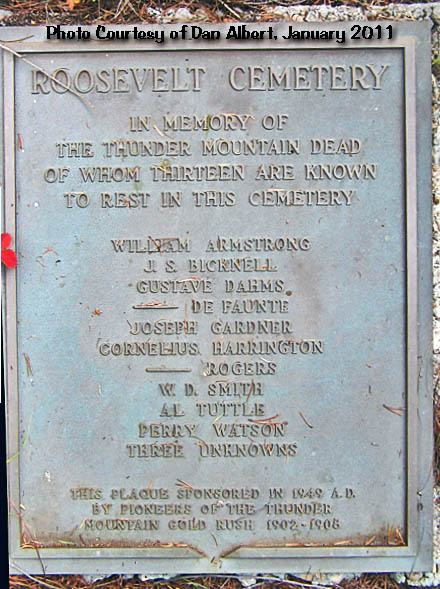
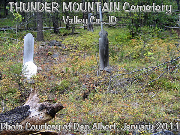
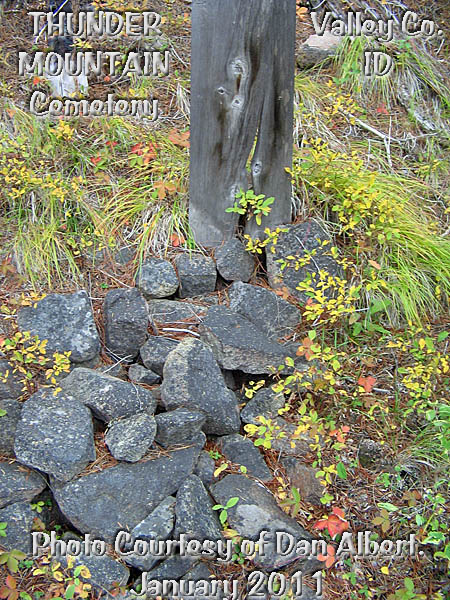
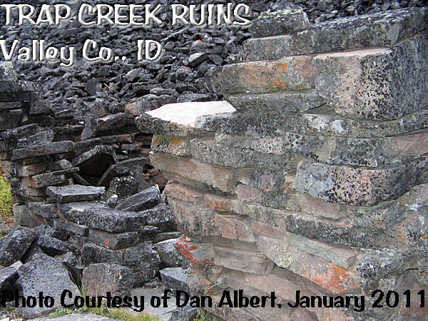
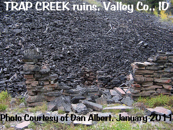
THUNDER
MOUNTAIN |
Valley
Co. |
Site of a gold rush in
1902-1908. The Roosevelt
Cemetery has at least 13 graves in it. Numerous grave
markers and headboards
remain. It is not shown on the GNIS
database, but Roosevelt Lake is.
Thunder Mountain is located near the mountain of the same name, about a
dozen AIR miles northeast of Stibnite.
The GNIS topo doesn’t show a named Thunder
Mountain mine or camp, others on the northeast flank of the mountain include:
Sunnyside Mine, Dewey Mine, and Venable Mine.
There is also a Belleco (site)
indicated. All lie east of Monumental
Creek. Along the creek, west of the
peak is the Twentieth Century Mill and Roosevelt Lake. Just north of Roosevelt lake is the mouth
to Trap Creek, where there are additional ruins. These consist of mortared-together flat
rocks stacked on top
of each other, the remains of a rock-walled
cabin at the base of a rock pile. Photos Courtesy of Dan Albert, January 1, 2011 ROOSEVELT LAKE ·
E-Ctr Sec 24, T19N, R10E, BM ·
Latitude:
44.9676976 / 44° 58’ 04” N ·
Longitude:
-115.1728541 / 115° 10’ 22” W THUNDER MOUNTAIN (peak) ·
SE¼ Sec 29, T19N, R11E, BM ·
Latitude:
44.9501881 / 44° 57’ 01” N ·
Longitude:
-115.1334376 / 115° 08’ 00” W MOUTH OF TRAP CREEK ·
NEC Sec 24, T19N, R10E, BM ·
Latitude:
44.9774101 / 44° 58’ 39” N ·
Longitude:
-115.1687167 / 115° 10’ 07” W |
VIENNA
|
Blaine
Co. |
A class B,
1880s silver mining town eight miles north of Sawtooth
City. Over 800 people lived and worked here between 1879 and 1892. Only
rubble remains, along with a forest service sign. ·
NE¼ Sec 32, T7N, R14E, BM ·
Latitude: 43.8165704 /
43° 49’ 00” N ·
Longitude: -114.8300695
/ 114° 49’ 48” W |
YELLOW DOG
|
Shoshone
Co. |
Part of the Gem to
Burke strip of mining camps in the canyon northeast of Wallace, Yellow Dog in
2009 consisted of a handful of old mobile homes and a few cabins located
north of the road and creek just west of Cornwall, 1.6 miles northeast of the
large brick assay office in Gem and 1.3 miles southwest of the huge mill
building in Burke. It is not shown on
GNIS. ·
SW¼ Sec 9, T48N, R5E, BM ·
Latitude:
47.516998 ·
Longitude:
-115.842977 |
YELLOWJACKET
|
Lemhi
Co. |
“Yellowjacket had a stamp mill
with many of the stamps still in the frames. There were also many buildings,
some cabins, part of the mill building and the
standing remains of a five-story hotel.
Yellowjacket seemed to have a caretaker but
no one was there when we were. This
site was accessible by passenger car in the summer, but at least high
clearance would be advisable. We visited this site in 2000 before the really
bad fire season so I don't know what is left.” Contributed
by “abbzug” (06/30/2003) GNIS also shows a cemetery there. It is shown on
NFD 112 Road and buildings are shown on the GNIS aerial photo and topo map. (GBS) ·
S-Ctr Sec 8, T4N, R10E, BM ·
Latitude: 44.9796397 /
44° 58’ 47” N ·
Longitude: -114.5317520
/ 114° 31’ 54” W |
MORE INFORMATION
|
Historians estimate that there may be as many as
50,000 ghost towns scattered across the The Ghost Town
Guru's Guide to the Ghost Towns of “STATE”™ These original guides are designed for anybody
interested in ghost towns. Whether you are a casual tourist looking for a new
and different place to visit, or a hard-core ghost town researcher, these
guides will be just right for you. With over 30 years of research behind
them, they will be a welcome addition to any ghost towner's
library. Thank
you, and we'll see you out on the Ghost Town Trail! For
more information on the ghost towns of Ghost
Town E-mailers, PLEASE NOTE: Due
to the tremendous amount of viruses, worms and “spam,” out there, I no longer
open or respond to e-mails with unsolicited attachments, OR messages on the
subject lines with “Hey”, “Hi”, “Need help”, “Help
Please”, “???”, or blank subject lines, etc. If you do send E-mail asking for
information, or sharing information, PLEASE
indicate the appropriate location AND
state name, or other topic on the “subject” line. THANK
YOU! :o) |
IMPORTANT These listings and historical vignettes of ghost
towns, near-ghost towns and other historical sites in IDAHO above are for
informational purposes only, and should NOT
be construed to grant permission to trespass, metal detect, relic or treasure
hunt at any of the listed sites. If the reader of this guide is a metal detector
user and plans to use this guide to locate sites for metal detecting or relic
hunting, it is the READER'S
responsibility to obtain written permission from the legal property owners.
Please be advised, that any state or nationally owned sites will probably be
off-limits to metal detector use. Also be aware of any federal, state or
local laws restricting the same. When you are exploring the ghost towns of Ghost Towner's
Code of Ethics. |
Also visit: Ghost Town
Home
Page | Site Map | Ghost Town Listings
| On The Road Again | Photo Gallery
| Treasure
Legends
CURRENT Ghost Town of the
Month | PAST Ghost Towns
of the Month
Ghost Towner's
Code of Ethics | Publications | Genealogy
| License Plate
Collecting
A few LINKS to outside webpages:
Ghost
Towns | Treasure
Hunting | License Plate
Collecting | Genealogy
***
THIS PAGE
FIRST POSTED: June 01, 2000
***
This entire website, and all individual web pages
is
copyright
© 1998-2015
by Gary B Speck Publications
ALL rights
reserved