Ghost Town
Guide to the Ghost Towns of
“The
PLEASE HELP!
I am still looking for historical information on
Do you have Gary’s Ghost Town books?
Dust in the Wind - A Guide to
American Ghost Towns GHOST
TOWNS: Yesterday & TodayTM Become a friend of the book on Facebook ***
Return to Ghost Town USA’s State Listings
*** Visit Ghost Town USA’s Ghost Town of
the Month *** Visit Ghost Town USA’s Home Page *** Visit Ghost Town USA’s Photo Gallery *** Ghost
Town USA’s Site Map
*** Send E-mail to Ghost Town USA. *** Western & Eastern Treasures Ghost Town USA Column Index for California. |
Today, That
gold nugget changed From
the western From
crumbling desert ruins to the majestic ghost of Bodie,
to the remains of hundreds of transient 49'er gold camps, Some of the vignettes
below contain specific words that are listed on our DEFINITIONS
page. If you are unfamiliar with the
meaning of the word in a ghost town sense, click on the link and scroll down
to that term. You can use the BACK
button on the browser to return to this page. We visited a number of California’s
ghost towns during the summer of 2008, and that journey is documented on a
new set of pages titled On
The Road Again. This specific journey was across US
Highway 6. The portion we explored was from Laws, California through
Price, Utah, including the full distance across Nevada. The towns we traveled through are listed
below. Follow the links to the
appropriate pages for details. HELP! (NEW FEATURE)
Please check here to find a list of ghost towns that various contacts are
looking for. IF you have any
information on these places please e-mail me and I can respond back to those looking
for info on these ghosts. PLEASE NOTE: Where photos are
indicated thusly (PHOTO!),
please use your browser’s “BACK” button to return to this page. More photos will be added over time. Where individual pages are noted, any
photos will be linked from that page and not this state page. |
|
|
Mariposa
Co. |
An 1849 era mining
camp located west of Mariposa.
It was the original county seat for See our AGUA
FRIA page for additional details. |
Alcatraz
|
San
Francisco Co. |
See our Alcatraz
page for additional details. |
Alum Rock Park
|
Santa
Clara Co. |
This class B former resort is located in See our Alum
Rock Park page for additional
details. |
|
San
Bernardino Co. |
The badly faded class D road
town of AMBOY sits on old US 66. As an outside website claims – rightfully
so – “Amboy is the crustiest, dustiest gas stop on all of Route 66. Pure untouched See our Amboy
page for additional details. |
|
|
|
Mariposa
Co. |
The class B
gold mining and milling town of See our BAGBY
page for additional details. |
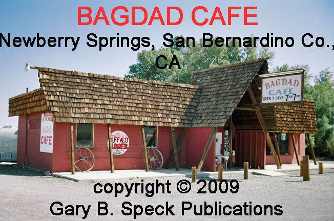
Bagdad
|
San
Bernardino Co |
Visit the class B
roadtown where the movie Bagdad Café supposedly took place. It was actually filmed in nearby Newberry
Springs where the Bagdad
Café restaurant is located. See our BAGDAD
page for additional details. |
|
|
Mariposa
Co. |
This
class D
gold mining town is located at the junction of SH 49/CR J-16, 12 miles
northwest of Mariposa. The first gold
was found about 1850 by Mexican miners who were consequently driven out. By 1851 the population had reached several
thousand. See our BEAR
VALLEY page for additional details. |
BEND
|
Inyo
Co. |
Melted piles of adobe,
some rusty cans and foundation depressions are all that mark this class B,
1860s era gold mining/milling town. It was located on a bend of the now-dry
Owens River, north of Two nearby locations
include…
·
NW¼ Sec 13, T13S,
R35E, MDM (Mount Diablo Base Line & Meridian) ·
Latitude: 36.805634 ·
Longitude: -118.122532 KEARSARGE STATION ·
E½ Sec 13, T13S,
R35E, MDM ·
Latitude: 36.8068763 / 36° 48’ 25” N ·
Longitude: -118.1173143 / 118° 07’ 02” W SAN CARLOS ·
Center Sec 2, T13S, R35E,
MDM ·
Latitude: 36.839103 ·
Longitude: -118.143196 (APPROX) |
|
Mono
Co. |
BENTON HOT SPRINGS is an old class D,
silver mining town dating back to the 1860s, while See our Benton & Benton Hot Springs page for additional details. |
|
BODIE
|
Mono
Co. |
This totally abandoned 1880s-1930s, class C,
gold-mining city has over 150 buildings still standing. It is located at east end of See our BODIE
page for additional details. This is
one of the towns featured in my newest book, GHOST
TOWNS: Yesterday & TodayTM. |
BOMBAY
|
Imperial
Co. |
This is one of the
half-dead class D towns
ringing the shores of the PLEASE SEE NOTE in the This is one of the towns featured in my newest book, GHOST
TOWNS: Yesterday & TodayTM. ·
NW¼ Sec 33, T9S, R12E, SBM (San Bernardino Base Line & Meridian) ·
Latitude: 33.3508667 / 33° 21’ 03” N ·
Longitude: -115.7297152 / 115° 43’ 47” W |
CALICO
|
San
Bernardino Co. |
This class C/F
(reconstructed) 1880s silver-mining
camp is on the south flank of the ·
N-Ctr
Sec 22, T10N, R1E, SBM ·
Latitude: 34.9488716 / 34° 56’ 56” N ·
Longitude: -116.8650363 / 116° 51’ 54” W |
|
|
Inyo
& Mono Co. |
The Carson & Colorado Railroad once ran the length of See our Carson
& Colorado Railroad page for additional
details and a list of the various towns that lined its route. |
|
CERRO GORDO |
Inyo
Co. |
COMING SOON ·
S-Ctr Sec 13, T16S, R38E, MDM ·
Latitude: 36.5393799 / 36° 32’ 22” N (MINE) ·
Longitude: -117.7917440 / 117° 47’ 30” W (MINE) |
|
CHALFANT |
Mono
Co. |
SEE On the
Road Again - PART
1 |
CHINA
CAMP
|
Marin
Co. |
This is a class C,
1870s-1880s era Chinese fishing camp on the south shore of See our |
COLOMA
|
El
Dorado Co. |
This class D/F
(partially restored) town was birthplace of the California Gold Rush, back in
January 1848. The See our COLOMA
page for additional details. |
|
|
Mariposa
Co. |
Coulterville dates to 1849 and is still a busy
little class
E town. It has numerous
landmark buildings and is a worthwhile stop.
It is located on SH 49, north of Mariposa in the Southern Mines
portion of the Motherlode. See our COULTERVILLE
page for additional details. |
DALE
MINING DISTRICT
|
Riverside
& San
Bernardino Co. |
This turn of the 20th-Century
gold mining district consists of dozens of mines,
several mill sites and a handful of class B
mining camps. It is located east of Twentynine
Palms and north of Joshua Tree National Park, straddling the See our DALE
MINING DISTRICT page for additional
details. |
DARWIN
|
Inyo
Co. |
This wonderful little class D
silver mining town is located west of Death Valley, east of Lone Pine and
north of the See our Darwin
page for additional details. This is
one of the towns featured in my newest book, GHOST
TOWNS: Yesterday & TodayTM. |
Death
Valley
|
Inyo
Co.. |
See our Death
Valley page for
additional details of a number of the old ghost towns. |
desert
center
|
Riverside
Co. |
This sunblasted, decaying
road town plopped in the center of the desert is slowly fading into the past
despite the efforts of the town’s owner, the granddaughter of the original
founder, Desert Steve Ragsdale. It
consists of a cluster of mostly vacant buildings. The only active businesses are the post
office (92239) and the Desert Center Café, which serves locals and travelers
alike. The rest of the town is dead,
and empty shell of what once was. It
sits right off I-10 at Exit 192, 50 miles east of Indio and 50 miles west of
Blythe. See our desert center page for
additional details. This was
our Ghost
Town of the Month for August/September 2011. |
Desert
Shores
|
Imperial
Co. |
PLEASE SEE
NOTE in the This is one
of the towns featured in my newest book, GHOST
TOWNS: Yesterday & TodayTM. See our Desert
Shores page for additional details. |
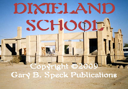
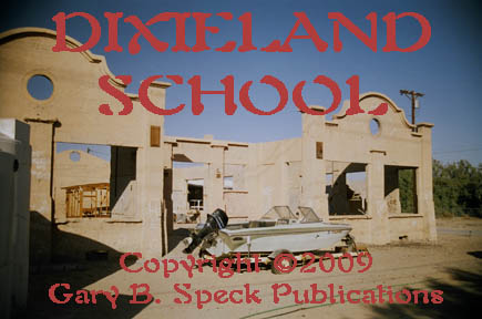
DIXIELAND
|
Imperial
Co. |
This tiny faded town sits along the PLEASE SEE NOTE in the ·
N½ Sec 7, T16S, R12E, SBM ·
Latitude: 32.7908915 / 32° 47' 27" N ·
Longitude: -115.7702814 / 115° 46' 13" W |
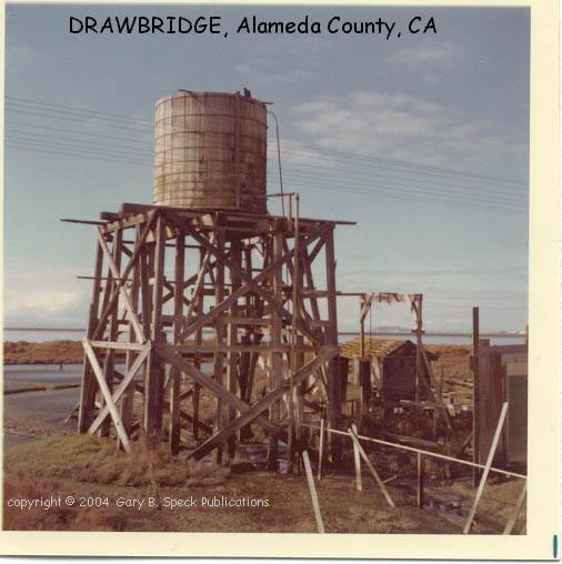
DRAWBRIDGE
|
Alameda
Co. |
Now part of Fremont, this class C,
former hunting retreat/town is located on a mud island along the Southern Pacific
Railroad just north of the county line, along the ·
T5S, R1W, MDM (Sections not shown on GNIS) ·
Latitude: 37.4663279 / 37° 27' 59" N ·
Longitude: -121.9743600 / 121° 58' 30" W |
EAGLE
MOUNTAIN
|
Riverside
Co. |
This class D
(soon to be class C)
iron-mining company
town is located at the massive See our Eagle Mountain page for
additional details. |
FortS
of the SF Bay REGION
|
Marin
& San
Francisco Co. |
Along the shoreline of
the Golden Gate (entrance to San Francisco Bay, on both the north (Marin Co.)
and south (San Francisco Co.) sides coastal defense forts bristled with
cannons to deter any would-be attackers from entering San Francisco Bay. By the 1990s they had shut down and had
been decommissioned. See our Coastal
Defense Forts page for additional
details |
GARLOCK
|
Kern
Co. |
The crumbling remains of this class C,
1890s gold ore-milling town straddles This is
one of the towns featured in my newest book, GHOST
TOWNS: Yesterday & TodayTM. ·
NE corner Sec 21, NW
corner Sec 22, T29S, R39E, MDM ·
Latitude: 35.4024608 / 35° 24' 09" N ·
Longitude: -117.7900644 / 117° 47' 24" W |
|
Madera
Co. |
This old class A town
was located along the See our Gertrude page for additional details. |
|
|
HAMMIL |
Mono
Co. |
SEE On the
Road Again - PART
1 |
|
San
Luis Obispo Co. |
This former dairying center sits on the Central
California coast between San Luis Obispo and Cambria. It was originally founded in 1869 and faded
out in the 1930s. Today this quirky, pint-sized townlet
looks nothing like what most folks consider a standard ghost town, even
though its aged Main Street was once the state highway, and the buildings look
as old as they are. But there’s
something else at work here that makes this laid-back minitown
wear larger than it really is…. See our HARMONY page for additional details. |
|
HARMONY BORAX WORKS
|
Inyo
Co. |
This 1890s borax processing facility is a class B/F
ghost, located a quarter mile west of SH 190 two miles north of Furnace Creek
Ranch, in Death Valley National Park. Remains include the semi-restored plant
and a couple roofless buildings on the flat below. Harmony Borax Works is California Historic
Landmark #773. ·
SE¼ Sec 9, T27N, R1E,
SBM ·
Latitude: 36.4821702 / 36° 28' 56" N ·
Longitude: -116.8733864 / 116° 52' 24" W |
|
HOLCOMB |
San
Bernardino Co. |
Several old class A &
B Civil War era gold-mining camps dot this high country valley
located north of SITE OF ·
Ctr Sec 33, T3N, R1E, SBM ·
Latitude: 34.3011166 / 34° 18' 04" N ·
Longitude: -116.8841985 / 116° 53' 03" W |
|
Mariposa
Co. |
This class D,
pioneering mining camp was established in 1848 by Mexican miners, and was
quickly over-run by “less desirable elements” evicted from the booming mining
town of Quartzburg about two miles away.
Hornitos quickly developed a reputation as a rough town. However, it eventually settled down and
became a respectable community, eclipsing Quartzburg.
See our HORNITOS
page for additional details. |
|
|
KEANE WONDER MINE |
Inyo
Co. |
Located in the heart of ·
SW¼ Sec 32, T30N, R1E, SBM ·
Latitude: 36.6816147 / 36° 40' 54" N ·
Longitude: -116.9000577 / 116° 54' 00" W |
|
Inyo
Co. |
Wiped out by an avalanche,
the name in celebration of a Union victory in the Civil War, and the site of
much silver, this itchy-footed Civil War era silver-mining town was located
above See our Kearsarge page for additional details. |
|
|
San
Bernardino Co. |
This class D railroad town is located in the
heart of the Mojave Desert about 35 miles southeast of Baker, on the west side
of the Providence Mountains, this former railroad helper and watering station
and siding contains one of the West’s premier ghost town buildings, the old
Union Pacific Railroad Depot, now fully restored and open to the public. It serves as the visitor center for Kelso
and the Mojave National Preserve. See our Kelso
page for additional details. |
|
|
Stanislaus
Co. |
Located on the
Stanislaus River just west of the main part of the Mother Lode, Knights Ferry
is an old travel town that once hosted a large milling complex, and still
features one of California’s few remaining covered bridges. See our Knights
ferry page for additional details. |
|
|
LAWS |
Inyo
Co. |
SEE On the Road Again - PART
1 |
|
Inyo
Co. |
This one-time travel
stop was located on the west side of present US Highway 395, at the southern
end of See our Little
Lake page for additional
details. |
|
LLANO
DEL RIO
|
Los
Angeles Co. |
This class B,
early 1900s utopian commune straddles SH 138, 20 miles east of Palmdale,
along the south edge of the See our LLANO
DEL RIO page for additional details. |
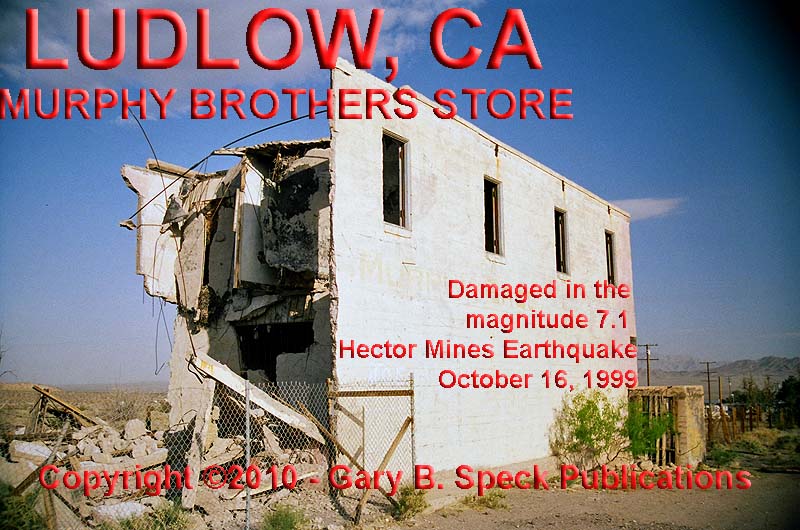
LUDLOW
|
San
Bernardino Co. |
This badly faded, class D,
·
S½ Sec 5, N –Ctr Sec 8, T7N, R8E, SBM RR Station
Site: ·
Latitude: 34.7211004 /
34° 43’ 16” N ·
Longitude: -116.1600117 / 116° 09’ 36” W Jct Crucero
Rd/Old Route 66: ·
Latitude: 34.723855 ·
Longitude: -116.163302 |
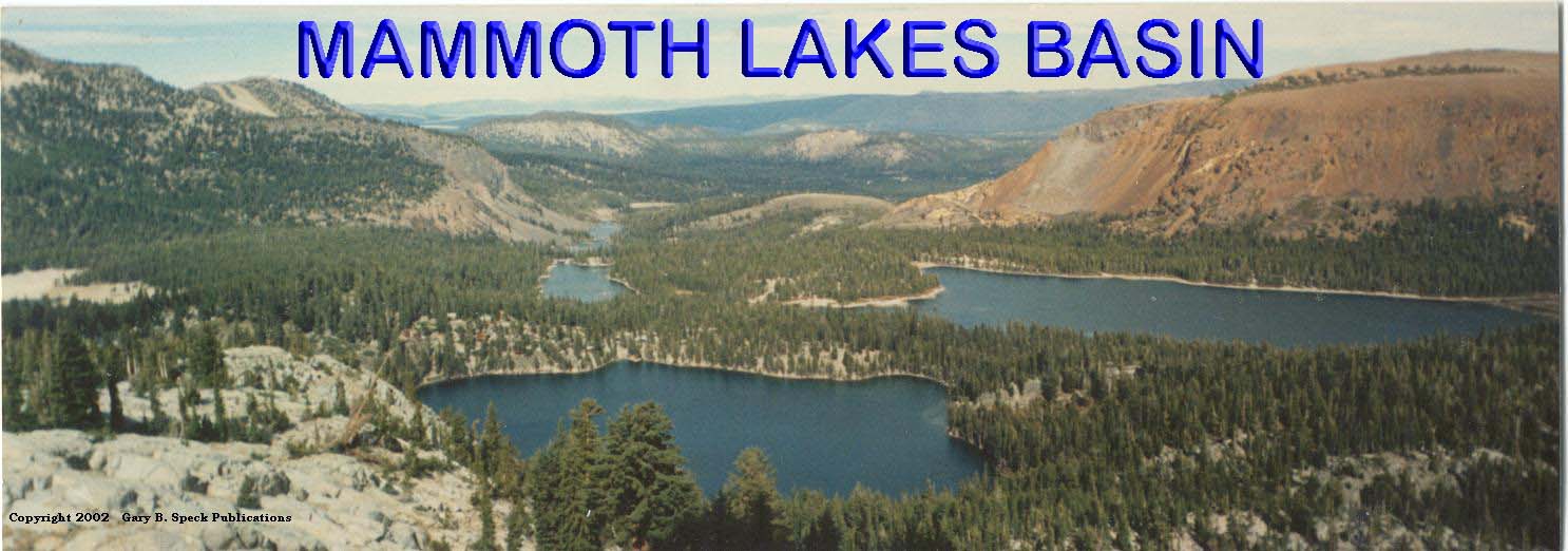
MAMMOTH
|
Mono
Co. |
This quiet, class B,
1880s gold-mining town is located just below the Mammoth
Lakes Basin,
which is located south of the Town of Mammoth Lakes. It stretches along ·
NE¼ Sec 9, T4S, R27E,
MDM ·
Latitude: 37.6161946 ·
Longitude: -119.0001351 |
MAMMOTH
CONSOLIDATED MINE
|
Mono
Co. |
This class C,
early 1900s mining camp is located in the pine forest just east of the
Coldwater Creek Campground, south of Lake Mary, in the Mammoth
Lakes Basin, about
five miles south of the Town of Mammoth Lakes. Remains include a number of restored
cabins and other buildings, as well as mines and mill ruins. I visited this old site in August, 2011,
and some of the buildings are beginning to collapse. IF you have not visited this little ghost,
I would HIGHLY recommend a visit in the next year or so before those failing
structures are demolished or collapse of their own accord. ·
NW¼ Sec 22, T4S, R27E, MDM ·
Latitude: 37.592199 ·
Longitude: -118.992105 |
MANZANAR
RELOCATION CENTER
|
Inyo
Co. |
This class B/F,
Japanese relocation center was active between 1942 and 1945. It is located in
See our MANZANAR
RELOCATION CENTER page for additional details. |
MARICOPA
|
Kern
Co. |
This class E faded
oil boom town is located in the southwestern corner of the San Joaquin
(Central) Valley in the far southwestern part of the county. This was our Ghost Town of the Month for April 2011. See our MARICOPA page for
additional details.
|
|
|
Mariposa
Co. |
County seat for See our MARIPOSA
page for additional details. |
|
MONO MILLS |
Mono
Co. |
The ruins of this 1880s, class B,
sawmill are located on the north side of SH 120 at a point 9.2 miles east of
US 395. The junction is 0.4 miles south of the north end of the June Lake
Loop, on the south side of ·
NE¼ Sec 2, T1S, R27E, MDM ·
Latitude: 37.8874283 / 37° 53' 15" N ·
Longitude: -118.9593089 / 118° 57' 34" W |
|
MONTGOMERY CITY |
Mono
Co. |
SEE On the
Road Again - PART
1 |
|
Mariposa
Co. |
This
once-flourishing mining town dates to 1850.
It is located on SH 49, about 4.7 miles northwest of Mariposa. It was the center of a large placering area as well as being the main support center
for the famed Princeton Mine. See our MOUNT
BULLION page for additional details. |
|
|
Riverside
Co. |
This badly faded class D Salton
Seaside resort and marina community is located on the northeastern shore of
the PLEASE SEE NOTE in the SALTON
SEA section below. See our North
Shore page for additional
details. This is
one of the towns featured in my newest book, GHOST
TOWNS: Yesterday & TodayTM. |
|
|
QUEEN DICKS |
Mono
Co. |
SEE On the Road Again - PART
1 |
Randsburg
|
Kern
Co. |
Randsburg is a fantastic, still
living, class
D mining town located on the northeast end of the Rand Mountains, a
mile west of US 395. Hands down, it is the best semi-ghost town in Southern
California. About 200 hundred folks still live here. Lots of buildings remain: some lived-in, others unoccupied. The Randsburg
General Store is still open, serving both residents and tourists
alike. Check out their bookshelf for
some great ghost town titles, including my two books, Dust in the Wind - A Guide to
American Ghost Towns and GHOST
TOWNS: Yesterday & TodayTM. See our Randsburg
page for additional details. This is
one of the towns featured in my newest book, GHOST
TOWNS: Yesterday & TodayTM. |
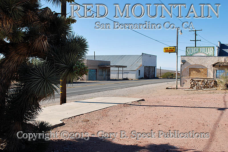
Red
Mountain
|
San
Bernardino Co. |
Red Mountain was the third boom
town to erupt in the Rand Mining District, coming onto the scene in 1919 with
the rich discovery of silver. It
lifted the moribund mining district into its third heady boom in twenty
years. Due to its isolated location,
Red Mountain was a true Wild
West town through the 1920s and even in its fading years through the
1930s. See
our Red
Mountain page for additional details and photos. |
SALTON
SEA
|
Riverside
& Imperial Co. |
This dying sea in the
southeastern part of the state is also ringed by many dead resorts and badly
fading towns. The Salton Sea was Southern
California’s resort and vacation REQUEST FOR INFORMATION: I am desperately looking for
information on a number of the marinas
and other shoreside
developments around the In addition, I am also seeking additional information about This is one of the locations featured in my newest book, GHOST
TOWNS: Yesterday & TodayTM. |
SHASTA |
Shasta Co. |
The red brick ruins of this class B former
1850s gold mining city still line the sides of SH 299, 10 miles west of See our SHASTA
page for additional details. |
SILVER
|
San
Bernardino Co. |
A few ruins and some rubble are all that remain
of this class
B, former Tonopah & Tidewater Railroad station alongside SH 127,
8.5 miles north of Baker, and just northeast of the dry bed of ·
SE¼ Sec 22, T15N, R82E, SBM ·
Latitude: 35.3702568 / 35° 22' 13" N ·
Longitude: -116.1155704 / 116° 06' 56" W |
Slab City/Camp Dunlap
|
Imperial
Co. |
This is the site of a World War II era U.S.
Marine training center east of Niland and the
Salton Sea, and just west of the PLEASE SEE NOTE in the SALTON
SEA section above. See our Slab City/Camp Dunlap
page for additional details. |
SOMERSVILLE
|
Contra
Costa Co. |
The rubbled site of Somersville is all that remains of one of a handful of
coal-mining camps that sprouted up on the northeast slope of See our |
SWANSEA
|
Inyo
Co. |
This class C, former
steamboat landing and smelter town is located on the north ·
S-Ctr Sec 24, T16S, R37E, MDM ·
Latitude: 36.5246569 / 36° 31' 29" N ·
Longitude: -117.9039708 / 117° 54' 11" W |
TUMCO
|
Imperial
Co. |
Deep in the southeastern corner of the state, Tumco is a class B
ghost, located northwest of PLEASE SEE NOTE in the SALTON
SEA section above. See our TUMCO
page for additional details. |
VOLCANO
|
Amador
Co. |
The California Gold Rush aura still exudes
throughout this wonderfully quiet and expressive class D,
gold rush era mining town located three miles northeast of Pine Grove. Pine Grove is on SH 88, eight miles
northeast of ·
SW¼ Sec 23, T7N, R12E, MDM ·
Latitude: 38.4429658 / 38° 26' 35" N ·
Longitude: -120.6307628 / 120° 37' 51" W |
ADDITIONAL CA GHOST TOWN LINKS
General
links to other ghost town sites can be found on our own Links page.
·
Nevada Ghost Towns- Over 600 Sites
in Nevada, Alone.
Includes a number of Death Valley and
Mojave Desert area
·
For recently departed
ghost towns, visit our ANOTHER
ONE BITES THE DUST page.
AMADOR Co.
·
Butler’s
Forgotten Gold Caches is one of our featured
Lost Treasure Legends.
IMPERIAL Co.
·
Imperial
County Ghost Towns Wanted!
INYO Co.
·
The Lost Gunsight Mine is one of our
featured Lost Treasure Legends.
·
Lost silver on Owens
Lake. This
is another of our featured Lost Treasure Legends.
·
Tonopah
& Tidewater Railroad.
For a good historical perspective
on one of
KERN Co.
·
The Exposed
Treasure Mine was a nice little mining camp that still had buildings as
late as the mid 1980s. It has since been
covered up by a mining operation that has since closed.
·
Located south of Lake Isabella, in the
heart of the Tehachapi Mountains is the old mining town of Bodfish,
now a quiet mountain town. In Bodfish, the Corlew family
operates Silver City Ghost
Town as an outdoor museum filled with buildings brought in from all over the Kern County area
and set up as a replica mining town.
MARIPOSA Co.
Visit Ghost Town
PLACER Co.
·
Pioneer Mining Supplies in
SAN BERNARDINO
Co.
This
website features lots of information and history on the
·
Mojave
Desert Heritage & Cultural Association
Based in Goffs Schoolhouse,
this organization along with their sister organization, The Friends of the
Before there were
trains and cars there were trails and footpaths across the country. The Mojave Road stretched from the Colorado
River at Fort Mohave to Los Angeles
·
Tonopah
& Tidewater Railroad.
For a good historical
perspective on one of
TULARE Co.
The
MORE INFORMATION
|
Historians estimate that there may be as many as
50,000 ghost towns scattered across the These original guides are designed for anybody
interested in ghost towns. Whether you are a casual tourist looking for a new
and different place to visit, or a hard-core ghost town researcher, these
guides will be just right for you. With over 30 years of research behind
them, they will be a welcome addition to any ghost towner's
library. Thank
you and we'll see you out on the Ghost Town Trail! For
more information on the ghost towns of CALIFORNIA, contact us at Ghost
Town USA. E-mailers, PLEASE NOTE: Due
to the tremendous amount of viruses, worms and “spam,” out there, I no longer
open or respond to e-mails with unsolicited attachments, OR messages on the
subject lines with “Hey”, “Hi”, “Need help”, “Help
Please”, “???”, or blank subject lines, etc. If you do send E-mail asking for
information, or sharing information, PLEASE
indicate the appropriate location AND
state name, or other topic on the “subject” line. THANK YOU! :o) |
IMPORTANT These listings and historical vignettes of ghost
towns, near-ghost towns and other historical sites in CALIFORNIA above
are for informational purposes only, and should NOT be construed to grant permission to
trespass, metal detect, relic or treasure hunt at any of the listed sites. If the reader of this guide is a metal detector
user and plans to use this guide to locate sites for metal detecting or relic
hunting, it is the READER'S
responsibility to obtain written permission from the legal property owners.
Please be advised, that any state or nationally owned sites will probably be off-limits
to metal detector use. Also be aware of any federal, state or local laws
restricting the same. When you are exploring the ghost towns of Ghost Towner's
Code of Ethics. |
Also visit: Ghost Town
Home
Page | Site Map | Ghost Town Listings
| On
the Road Again | Photo Gallery
| Treasure
Legends
CURRENT Ghost Town of the
Month | PAST Ghost Towns
of the Month
Ghost Towner's
Code of Ethics | Publications | Genealogy
| License Plate
Collecting
A few LINKS to outside webpages:
Ghost
Towns | Treasure
Hunting | License
Plate Collecting | Genealogy
***
THIS PAGE
FIRST POSTED: June 01, 1998
***
This entire website, and all individual web pages
is
copyright
© 1998-2017
by Gary B Speck Publications
ALL rights reserved